

LA_COUNTY_FiREDATA
rashardmro.tumblr.com/post/801242206701830144/los-angeles-thermal-anomolies
@la-county-isd Janis HAhn , HildaSolis, HollyJMitchell . . . @emit-sds i am missing a tooth… a spunky redhead sang “My_POMONAAAH_MYY__PAMONA” on the LATTC metro platform, she was missing 3 bottom teeth! and about 3 months ago somone i suspect is a satellite builder was missing two bottom teeth in the front @paramount-engineering @netflix backing down, just sharing @blackgirlscode … anyway @NOAAgov is my domain as well according to @CityOfLosAngeles @nasa-jpl to get NasaFire data from to share with the county… The Palisades - Imagery https://storms.ngs.noaa.gov/storms/2025_eri/index.html#18.46/34.0459858/-118.5188729 its like a 30gb bundle so i have to back burner the thing @Maxar-Corp @airbus @esa @nasa-openscapes @eu-cdse
@la-county-isd @nasa-jpl i have a new perspective on the fire after last weeks tragedy in Georgia @cityoflosangeles @CityofSantaMonica @CityOfLosAngeles KarenBass @stateofcalifornia GavinNewsom, the @NOAAGov data set isolated and this band of night time imagery it looks like the illuminated part is the fire that cancels out like the mountains are light and then go dark VIIRS NOAA-20 (JPSS-1) 375m, I-Band Active Fire Product NRT (Vector Data) Link @nbcnews @cbs-news-data @datadesk
@blackgirlscode hope yall good @foratlanta
nasa-worldview-2025 JAN 05-to-2025 JAN 13
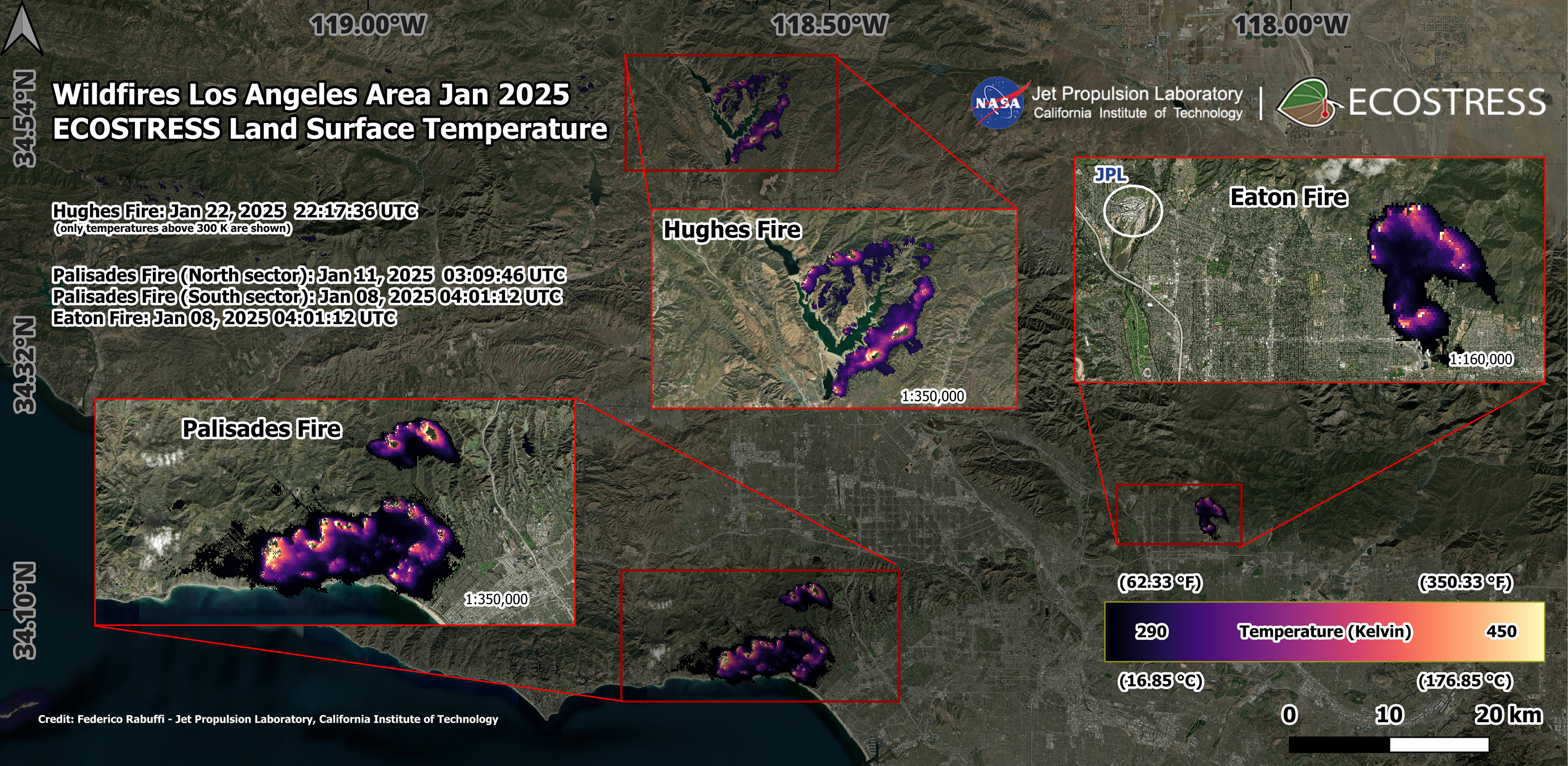
Overview Maps of 2025 Los Angeles Fires

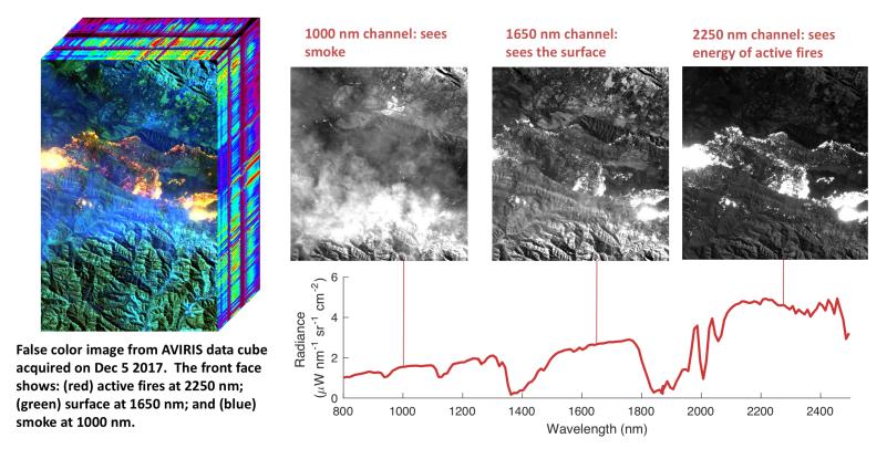
https://www.jpl.nasa.gov/missions/airborne-visible-infrared-imaging-spectrometer-aviris/ AVIRIS is the first full spectral range imaging spectrometer and dedicated to Earth Remote Measurements . . AVIRIS Flight Request Information - CLiCKHERE

Imagery for the January 2025 Southern California Wildfires
July 25, 2025 Link

planetLabs , @NASA ViSiBLE_EARTH Query
About One-third of Malibu Burned In The Palisades Fire. Where Does It Go From Here?
@nasa-jpl Latimes @datadesk made a doc @nasa
@la-county-isd @nasa-jpl @emit-sds hi you can see the outline of the fire in the palisades in this map! @whitehouse @fbicyber @dhs-gov
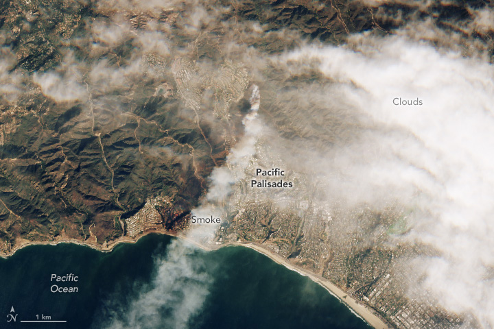
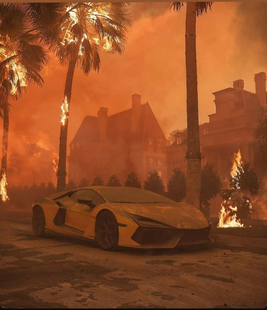
On January 7th, 2025, a series of wildfires started in the Southern California area, heavily affecting Los Angeles communities. The fires spread rapidly due to an abnormally dry year coupled with extreme winds raging at up to 100 miles per hour. Two of the fires, Eaton and Palisades, affected densely populated neighborhoods, spreading rapidly from structure to structure and combining to cause severe damage to over 16,000 homes and businesses. Released Friday, July 11, 2025
cartography
@stateofcalifornia @cityoflosangeles @nasa @dhs-gov
DOXXED FOR THIS DATA
🚫 Sorry, this post was removed by Reddit’s filters.
https://svs.gsfc.nasa.gov/5568/ Visualizations by: https://svs.gsfc.nasa.gov/5558/
Visualizations by:
Scientific consulting by:
Doug C. Morton @nasa @cityoflosangeles @stateofcalifornia @atfweb
Spread of the Palisades and Eaton Fires - January 2025
byu/Dizzy-Decision-2115 innasa
Overview Maps of 2025 Los Angeles Fires
On January 7th, 2025, a series of wildfires started in the Southern California area, heavily affecting Los Angeles communities. The fires spread rapidly due to an abnormally dry year coupled with extreme winds raging at up to 100 miles per hour. Two of the fires, Eaton and Palisades, affected densely populated neighborhoods, spreading rapidly from structure to structure and combining to cause severe damage to over 16,000 homes and businesses. Released Friday, July 11, 2025
@stateofcalifornia @cityoflosangeles @nasa @dhs-gov
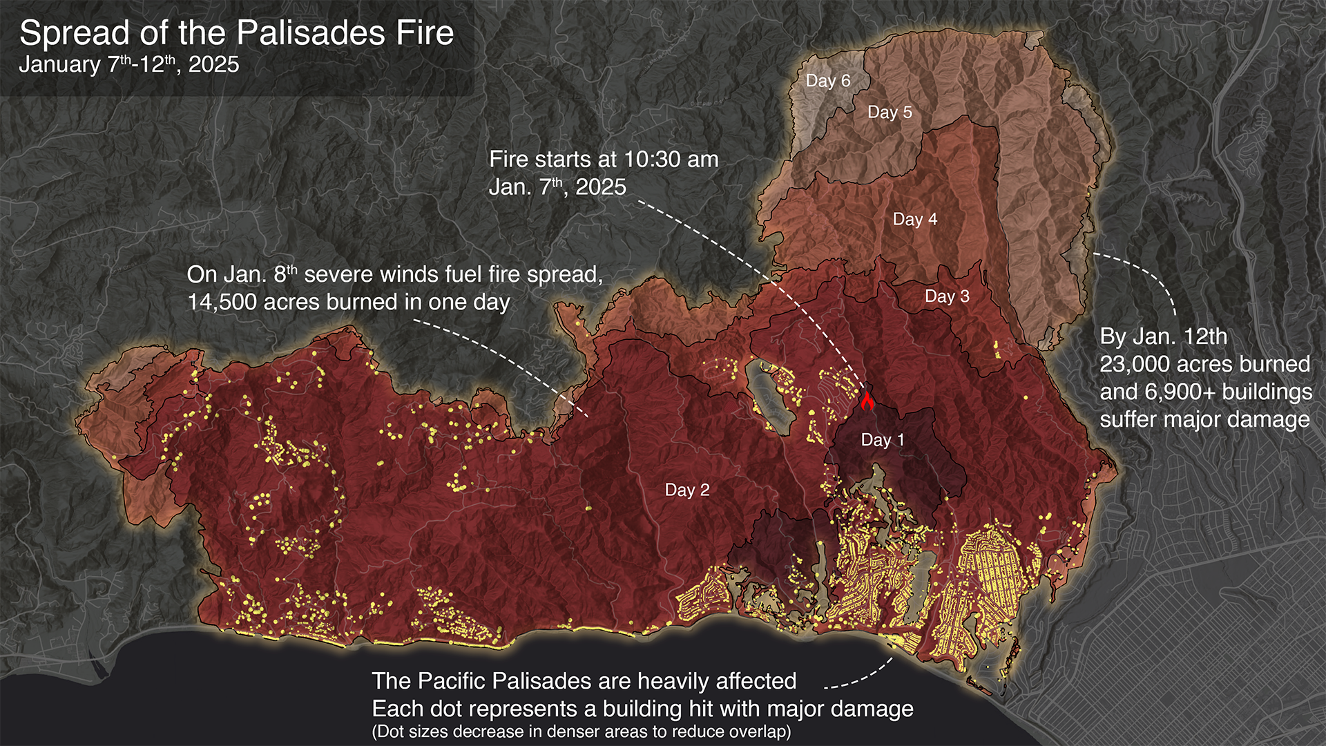
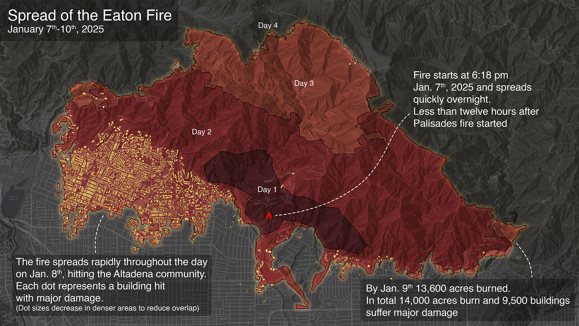
Table Mountain Facility Sends DSOC Laser Beacon to NASA’s Psyche (Infrared Image)
https://www.jpl.nasa.gov/images/pia26661-table-mountain-facility-sends-dsoc-laser-beacon-to-nasas-psyche-infrared-image/ // https://en.wikipedia.org/wiki/Table_Mountain_Observatory#/media/File:Table_Mountain_Observatory_control_room1.jpg
https://en.wikipedia.org/wiki/Table_Mountain_Observatory // https://lidar.jpl.nasa.gov/ndacc/sites/tmf.php // https://science.jpl.nasa.gov/projects/table-mountain-observatoryoptical-astronomy-tmo/ // https://locator.lacounty.gov/lac/Location/3070281/table-mountain-observatory // https://atmos.jpl.nasa.gov/ground.htm // https://www.pomona.edu/academics/departments/physics-and-astronomy/facilities/table-mountain-observatory // https://www.jpl.nasa.gov/images/pia26661-table-mountain-facility-sends-dsoc-laser-beacon-to-nasas-psyche-infrared-image/
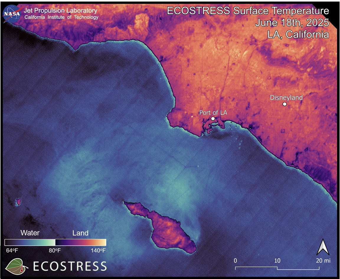
### Wildfires in Los Angeles, California Image captured on Jan 8, 2025 ECOSTRESS Data Incorporated Into New Wildfire Response Tool
Fires Tear Through Los Angeles Powerful Santa Ana winds and dry conditions contributed to the rapid spread of several brush fires in the county. ReadMoreSeemORe
Palisades Fire reaches Brentwood, threatens San Fernando Valley @ktla youtube.com

A view of the #EatonFire behind @NASAJPL Flight Projects Center. It feels like Armageddon around here pic.twitter.com/pPWJ0B2rIB
— Royce (@RobRoyce_) January 9, 2025
EatonCanyon UpDates
files :: Wiki :: TALK How NASA’s Infrared Imaging Uncovered the True Extent of Eaton Fire Devastation
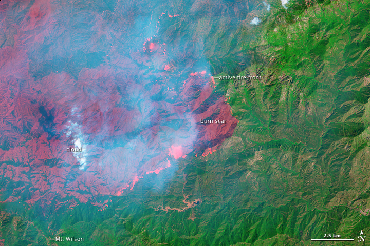
Spread of the Palisades and Eaton Fires - January 2025 @stateofcalifornia @cityoflosangeles @whitehouse @atfweb @cia @nasa @nasa-jpl Scientific consulting by: Doug C. Morton Visualizations by: Cindy Starr . . . fullcredits These visualizations highlight the spread of the 2025 Palisades and Eaton fires in California using a fire tracking approach (Chen et al., 2022) and near real-time active fire detections from the VIIRS sensors on the Suomi-NPP and NOAA-20 satellites. Every 12 hours, the fire tracking algorithm uses new active fire detections to update the total fire perimeter and estimate the position of active fire lines—active portions of the perimeter where the fire may continue to spread. READMORE
The Spread of the Palisades Fire
The Spread of the Eaton Fire
OLDTWEET JAN2025
Due to wildfire evacuations, the Lab is closed, except for emergency personnel. No fire damage has been reported. Follow updates at http://emergency.jpl.nasa.gov
Thanks to everyone for the concern for our center, but more importantly, for our colleagues and neighbors. Stay safe, LA. RelatedTweet
Altadena Community Meeting - June 23, 2025
@datadesk do you work for @nooa or @nasa @nasa-jpl @whitehouse or are you repackaging the data im not meddling, i just dont want to talk to strangers irl… -rashard
datadesk/nasa-wildfires - https://palewi.re/docs/nasa-wildfires/ Download wildfire hotspots detected by NASA satellites and the Fire Information for Resource Management System (FIRMS) @noaa -wildfires https://github.com/`your_account_name/yourfork.git +
= ![]() <~ your files inside! Thats MyBinder https://mybinder.org/
<~ your files inside! Thats MyBinder https://mybinder.org/
![]()
![]() NASA’s Jet Propulsion Laboratory manages the EcoStress mission for the Earth Science Division in the Science MissionDirectorate at NASA Headquarters in Washington
NASA’s Jet Propulsion Laboratory manages the EcoStress mission for the Earth Science Division in the Science MissionDirectorate at NASA Headquarters in Washington
 JPL Fire Victim interview
Bass fires the L.A. fire chief, but her own smoldering political crisis is far from over @datadesk LA Mayor Karen Bass facing recall effort over handling of Palisades Fire
JRE SUSPICIOUS Apollo 11 Post Flight Press Conference Apollo 11 Press Conference APOLLO 10 MISSION “GREEN LIGHT FOR A LUNAR LANDING” 1969 NASA FILM 42864 1966 MIT TV SHOW “SCIENCE REPORTER” RETURNING FROM THE MOON APOLLO PROGRAM 77454 LANGLEY Impact Basin (Building 1192)
@blackgirlscode Sim City 2000
 Los Angeles City Hall - https://waterandpower.org/
Los Angeles City Hall is one of the most iconic buildings in America; some say, the world. A bold symbol of the ambition of America and its people, City Hall graces California as one of its most enduring landmarks. Related - DNS
Los Angeles City Hall - https://waterandpower.org/
Los Angeles City Hall is one of the most iconic buildings in America; some say, the world. A bold symbol of the ambition of America and its people, City Hall graces California as one of its most enduring landmarks. Related - DNS

https://t.co/yRYjz7ac5K @SpaceForceDoD #HappyEaster2025 @normani @BlackGirlsCode @USSF_SSC https://t.co/i14IpyLUXk https://t.co/FjwlsLQ5TT @_FloMilli @NASAJPL @LACityView35 lets correct annie, it's old 1937 @LACo_DPSS @hot1079atl pic.twitter.com/a2gsaDa22N
— ricoThaka (@RicoThaka) April 19, 2025
#GM @NASAJPL @CAL_FIRE @LACityCouncil @LADWP , @ISS_Research is telling us we have #PalisadesFire ! #morninBae @normani the shitty film crew left a light shining like #AlBundyShoW
— ricoThaka (@RicoThaka) February 11, 2025
@latto! @lafd
https://t.co/R4H8mOPoPs: pic.twitter.com/9S5ds0CTp9
OrginTwT
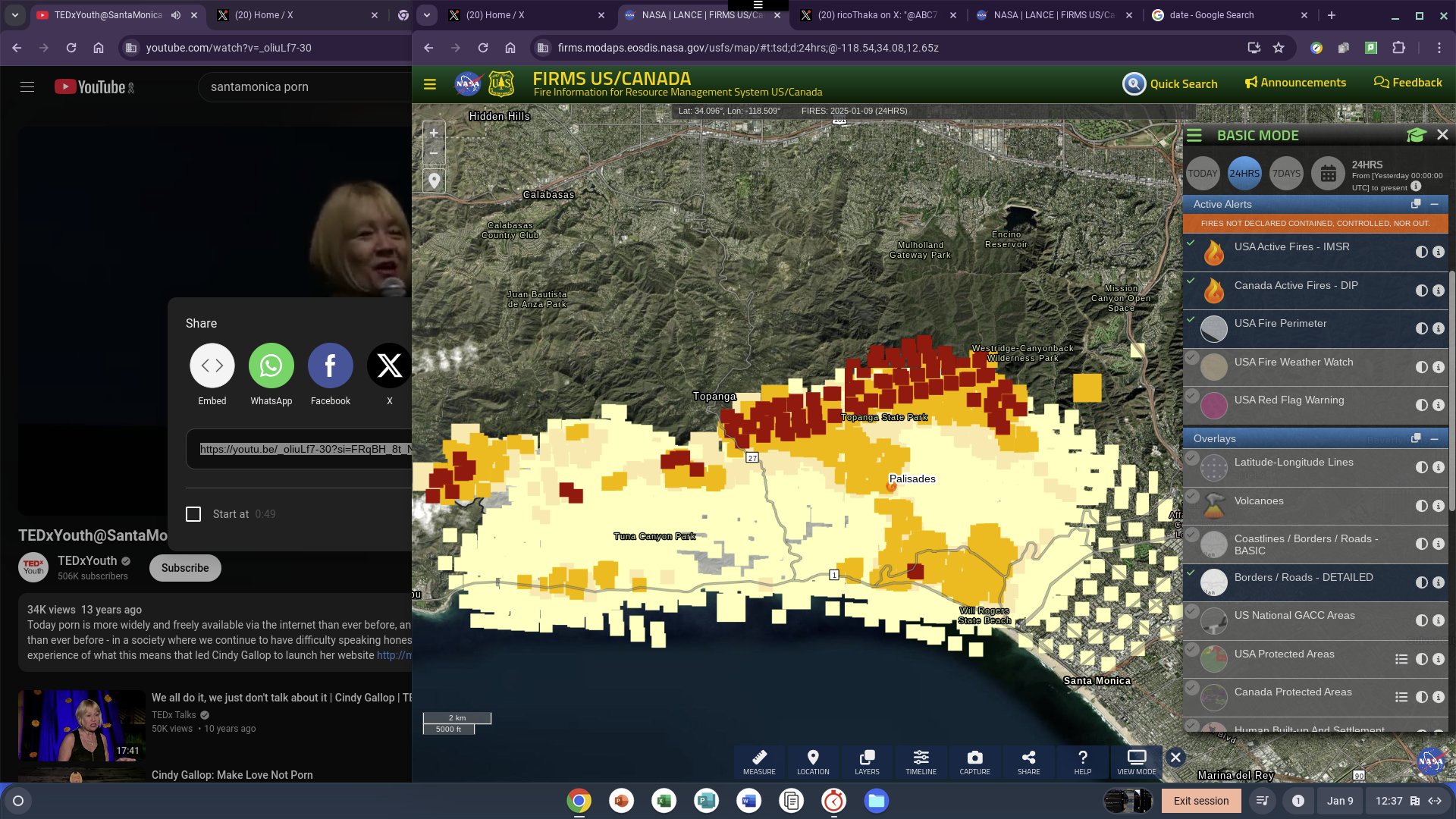
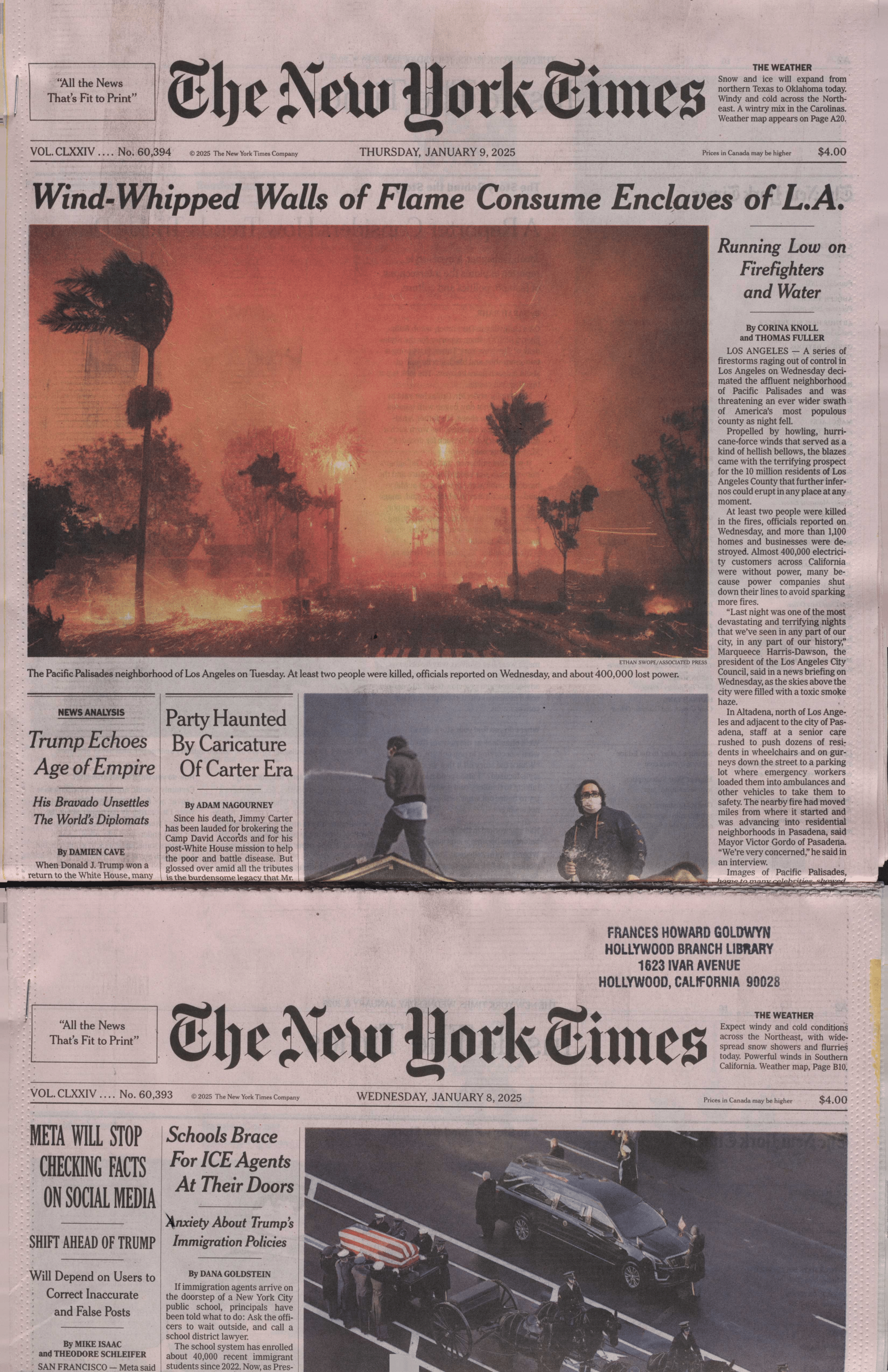
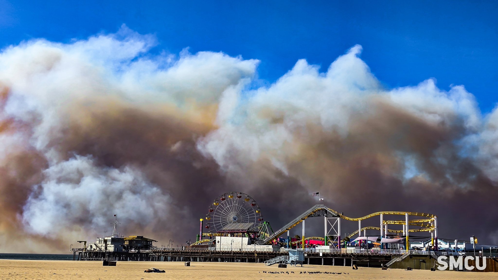


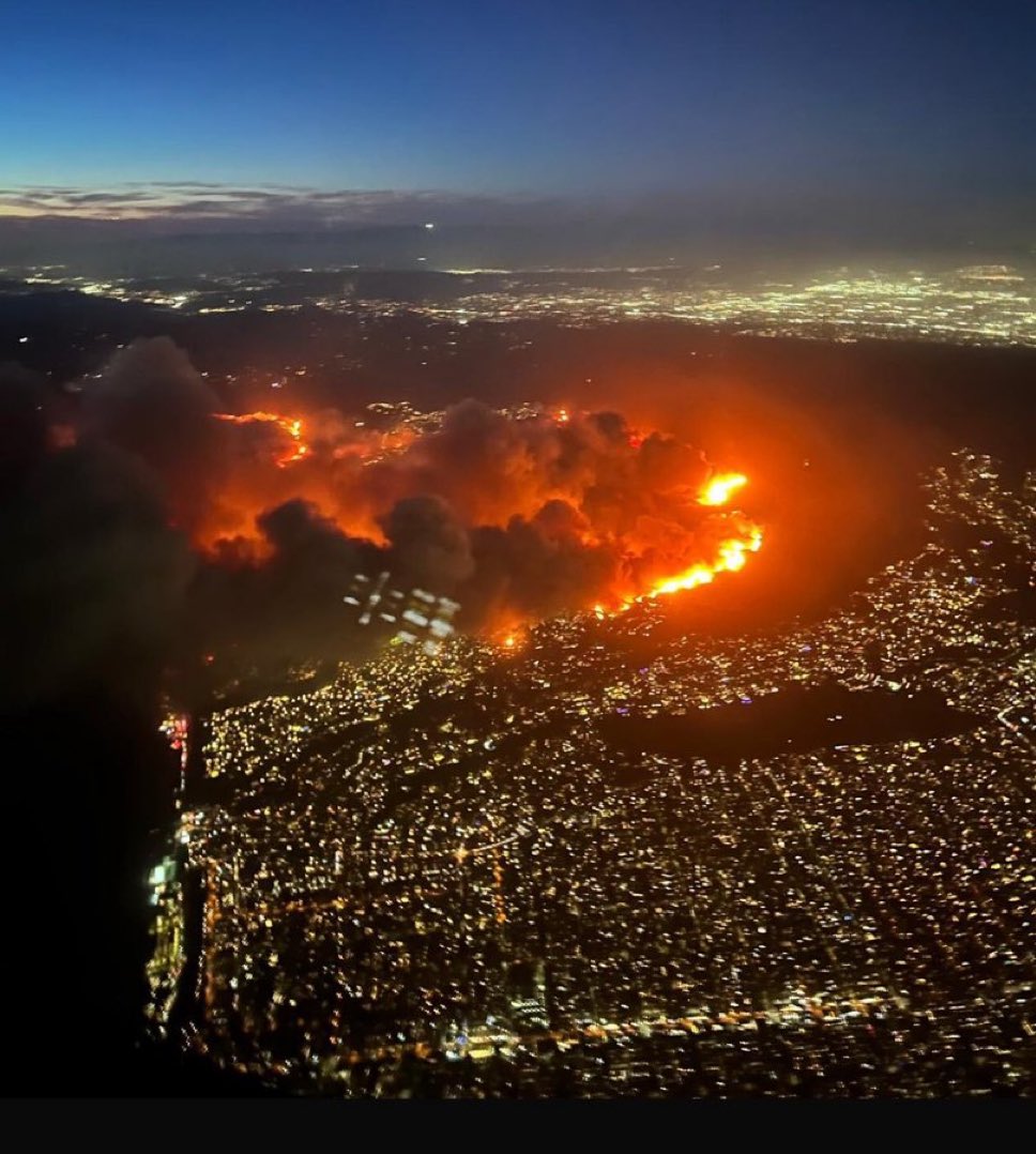
photo -@JackQuillinTV


TroubleShooting Smoke Mar21 @cityoflosangles GoogleEarth I smelled the smoke first getting off the metro at CivicCenter
Los Angeles Fires : Palisades : Pepperdine

FLiGHTLiNES.CSV Coast
Commit 4a8760a
#elnino @RepKarenBass @RealHWAtlanta @realDonaldTrump @normani pic.twitter.com/JXuedfs2zJ
— ThakaSartu KellySelassie (@thakasartu) January 30, 2025


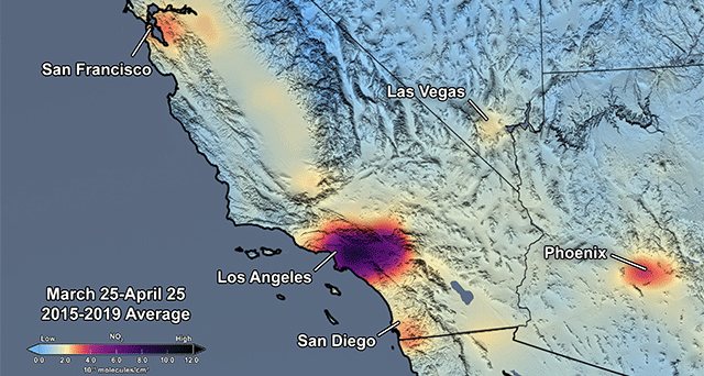
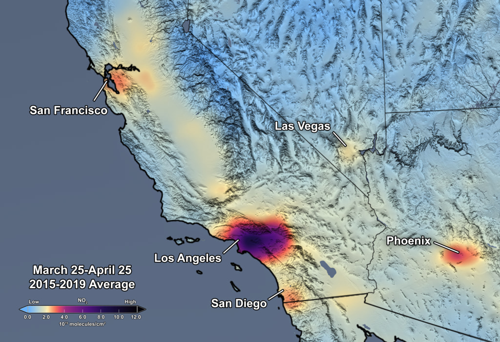
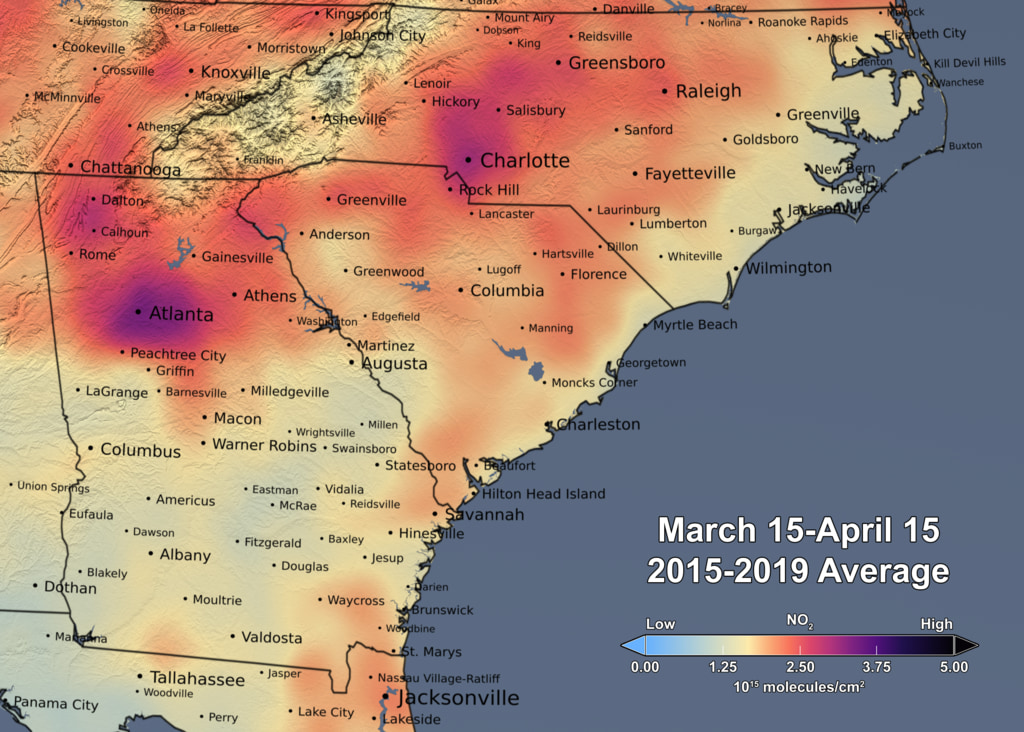
Nitrogen Dioxide over the Continental US and Los Angeles
Upon zooming into Southern California, finer details of pollution gradients are clearly visible over the Los Angeles/San Diego region. Here the concentration of NO2 is shown in shades of light blue to dark pink/purple indicating values ranging from low to high by CindyStarr Global Nitrogen Dioxide Monitoring Home Page @nasa @nasa-jpl @blackgirlscode @normani hi
2009 Fire
Reductions in Pollution Associated with Decreased Fossil Fuel Use Resulting from COVID-19 Mitigation
Released Friday, April 24, 2020
Written by: Bryan Duncan Over the past several weeks, the United States has seen significant reductions in air pollution over its major metropolitan areas. Similar reductions in air pollution have been observed in other regions of the world. READMORE Released Friday, April 24, 2020

GRACE and GRACE-FO track California’s land water changes
NASA’s Gravity Recovery and Climate Experiment (GRACE, 2002 - 2017) mission, and its successor GRACE Follow-On (launched in 2018), map month-to-month changes in Earth’s gravity field resulting from the movement of mass, such as water, near the surface of the planet. This animation shows how the total amount of water (snow, surface water, soil moisture, and groundwater) varies in space and time, with the passage of dry seasons and wet seasons as well as with flooding, drought, and transport due to water management. Blue colors represent wetter than average conditions (relative to 2004-2010), while red colors represent drier than average conditions. The yellow line in the graph on the left shows the evolution of the long-term inter-annual variations for the area outlined in yellow on the map (note: the average seasonal cycle has been removed).
The Sacramento and San Joaquin River basins are outlined in yellow, and rivers and tributaries are shown as blue lines. The basins include California’s Central Valley, the most productive agricultural region in the U.S. Repeated drought conditions and increased water use in California have led to a long-term decline of terrestrial water, interspersed with above-average precipitation periods (e.g., 2015/2016, 2022/2023) that have allowed some recovery of the land water storage.
Credit NASA / JPL
Science On a Sphere: 4 Years of Biosphere
RelatedTweet
By monitoring the color of reflected light via satellite, scientists can determine how successfully plant life is photosynthesizing. A measurement of photosynthesis is essentially a measurement of successful growth, and growth means successful use of ambient carbon. This data visualization represents four years’ worth of data taken primarily by Suomi NPP/VIIRS satellite sensors, showing the abundance of life both on land and in the seaREADMORE


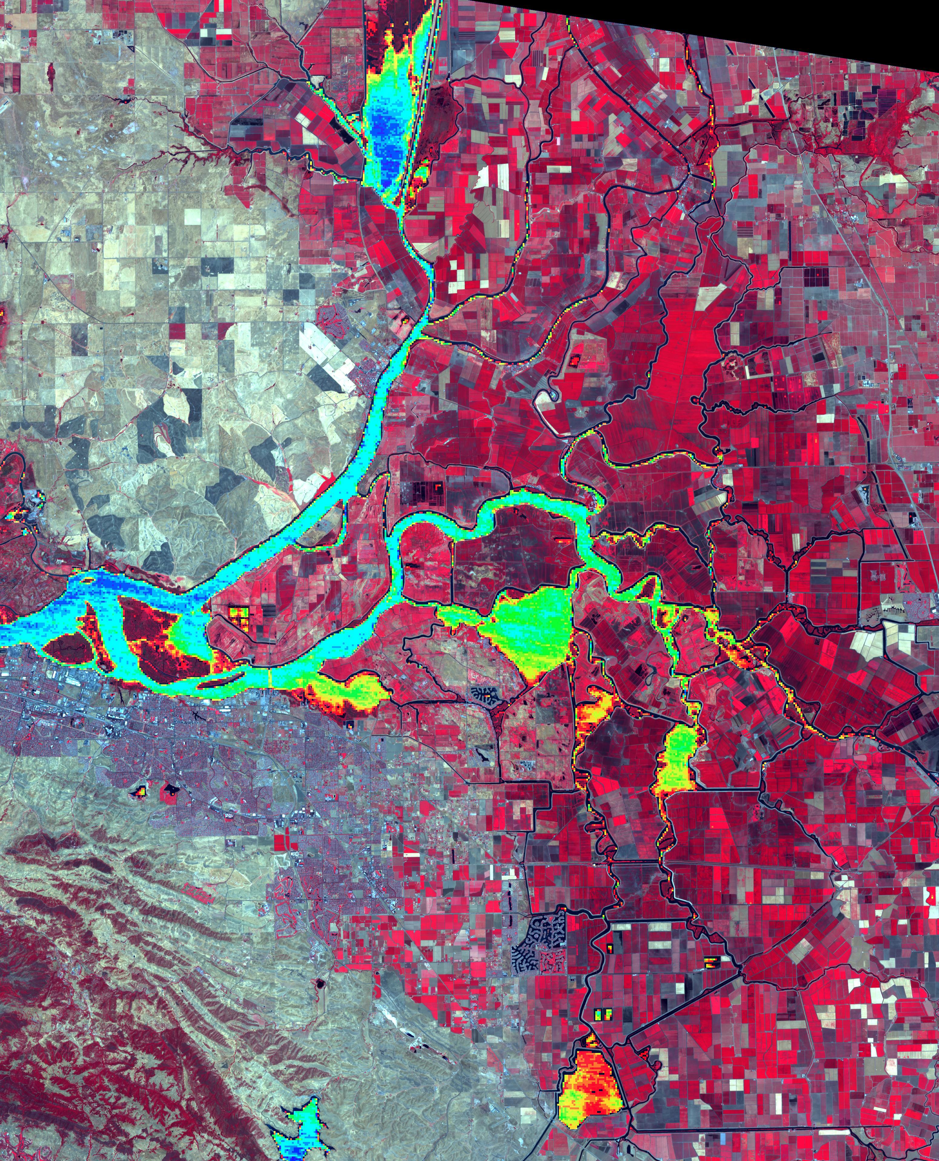
Levee Break Floods Central California

Gavin NEwsome
I left a tweet on your housefloor meeting
@usepa @nasa-jpl @usgs
EPA + WATER MAPS
NASA WORLDViEW Mar12 USGS WATERDASHBOARD Mar12

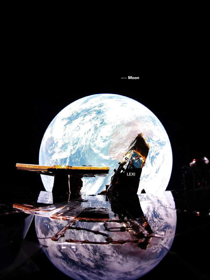
A Small Blue-Gray Marble
A digital camera on the Blue Ghost lander looked back at Earth and captured this ethereal image. - NASA VisiBLEEARTH FireFlyAeroSpace
Related Ocean FAM EuropaClipper Elon death graff more


![]() NASA’s Jet Propulsion Laboratory manages the EcoStress mission for the Earth Science Division in the Science MissionDirectorate at NASA Headquarters in Washington
JPL Fire Victim interview
NASA’s Jet Propulsion Laboratory manages the EcoStress mission for the Earth Science Division in the Science MissionDirectorate at NASA Headquarters in Washington
JPL Fire Victim interview

🇺🇸 #LAFires #CaliforniaFires #Arson #DEW #LandGrab #DirectedEnergyWeapons #WildFires #PalisadesFire #LosAngelesFires #California #LosAngeles #Malibu #SmartCity #Genocide
— 𝕁𝕒𝕕𝕖𝕕 (@Jaded42358177) February 23, 2025
Commie LA Mayor Karen Bass ‘Leaked Phone Call’
‘Read In Between The Lines…You Will Understand Soon pic.twitter.com/4ruylR9J02
OrginTwT
photo -@JackQuillinTV
TroubleShooting Smoke Mar21 @cityoflosangles GoogleEarth I smelled the smoke first getting off the metro at CivicCenter
![]() NASA’s Jet Propulsion Laboratory manages the EcoStress mission for the Earth Science Division in the Science MissionDirectorate at NASA Headquarters in Washington
JPL Fire Victim interview
NASA’s Jet Propulsion Laboratory manages the EcoStress mission for the Earth Science Division in the Science MissionDirectorate at NASA Headquarters in Washington
JPL Fire Victim interview
NEws for the MAyoR
PIA11243: NASA’s AVIRIS Instrument Sheds New Light on Southern California Wildfires EMit DATACUBE SAMPLE LA_PERCEPTiON To MALE JOURNALiST TALKiNG TO Ms_BASS Mayor_Gossip Reddit Post NEEDS PARSing @cityoflosangeles @nasa-jpl MayorTweetReddit
Bass fires the L.A. fire chief, but her own smoldering political crisis is far from over @datadesk LA Mayor Karen Bass facing recall effort over handling of Palisades Fire
Live Cams : CAlifornia
Moving Mountains Livestream 🔴 Venice V Hotel Live · Beach Live Camera · Los Angeles Live Stream Webcams - Los Angeles @foxbrodcasting @usgs @nasa @nasa-jpl Webcams in LOs ANgeles - https://www.outdooractive.com/ LOS_ANGELES - EarthCam.COM MArs Perception
LA _River
LosAngelesDns
Unless a company, university, or other group gets an officially sanctioned Internet name, it cannot conduct its business over the Net
@la-county-isd you guys had the best results in my most recent voayge with nslookup @CityOfLosAngles Im finxing some css errors Supervisor Mitchell but The CountyLibrary is serving from a .org see nslookup.io Report @nasa-jpl but they not on pphostd @whitehouse
GRACE and GRACE-FO track California’s land water changes
NASA’s Gravity Recovery and Climate Experiment (GRACE, 2002 - 2017) mission, and its successor GRACE Follow-On (launched in 2018), map month-to-month changes in Earth’s gravity field resulting from the movement of mass, such as water, near the surface of the planet. This animation shows how the total amount of water (snow, surface water, soil moisture, and groundwater) varies in space and time, with the passage of dry seasons and wet seasons as well as with flooding, drought, and transport due to water management. Blue colors represent wetter than average conditions (relative to 2004-2010), while red colors represent drier than average conditions. The yellow line in the graph on the left shows the evolution of the long-term inter-annual variations for the area outlined in yellow on the map (note: the average seasonal cycle has been removed).
      ___    _____     ___
    /_ /|  /____/ \  /_ /|       Horizons On-line Ephemeris System v4.98d
    | | | |  __ \ /| | | |       Solar System Dynamics Group
 ___| | | | |__) |/  | | |__     Jet Propulsion Laboratory
/___| | | |  ___/    | |/__ /|   Pasadena, CA, USA
|_____|/  |_|/       |_____|/

.org defined
This is an open TLD; any person or entity is permitted to register. Originally created as a miscellaneous category as stated in RFC 920 (October 1984) “…any other domains meeting the second level requirements,” and clarified in RFC 1591 (March 1994), “This domain is intended as the miscellaneous TLD for organizations that didn’t fit anywhere else. Some non-government organizations may fit here.”[9][10] While mainly non-profits have used this domain, it was never restricted from miscellaneous use. - Wikipedia b4 // women.ca.gov - snapshot // List of Internet top-level domains - wikipedia + The Top-level Domain Name Controversy - @ieee [1] ///
![]()
W3C CSS Validator results for http://ra5hard.github.io (CSS level 3 + SVG)
Sorry! We found the following errors (3)
URI : https://ra5hard.github.io/assets/css/style.css?v=dc80f4b81df2648a0d8efd7c93eb65c57ebb85f4
1	.scroller	Property container-type doesn't exist : inline-size
1	.item	Value Error : background-repeat none is not a background-repeat value : none
URI : https://ra5hard.github.io/
18	.navbar a	Value Error : padding 10x is not a padding value : 10x 10px
Link - Current ThermalAnomolies @newshour @blackgirlscode @gtri @gatech @nasa-jpl @caltech
L.A. Ecology @CityOfLosAngeles @Nasa-jpl
Remotely Estimating Total Suspended Solids Concentration in Clear to Extremely Turbid Waters Using a Novel Semi-Analytical Method - Link @blackgirlscode @blueorigin @thespacedevs @rocketlab dsnnow