

L.A. Ecology @CityOfLosAngeles @Nasa-jpl
Los Angeles County
AVIRIS-ng 2025Wildfire arcgis 2025fire palisades @esri portal of disaster dataretrival : Rashard Kelly NasaEArthdata @nasa-pds @nasa-jpl @cityoflosangeles @blackgirlscode wildfire @emit-sds wildfire @datadesk https://5WILDFIRE2VID_20251126_225215_114.mp4 /21_adult_EntertainmentZoning_LOS_ANGELES.pdf https://WILDFIRE2_20251126_224338_353.mp4 WILDFIRE1VID_20251126_224319_400.mp4
Tink - Fake Love watch
the coast looks cleaner @stateofcalifornia @cityoflosangeles
NASA’s Uninhabited Aerial Vehicle Synthetic Aperture Radar (UAVSAR), a reconfigurable, polarimetric L-band SAR, is specifically designed to acquire airborne repeat track SAR data for differential interferometric measurements. Differential interferometry can provide key deformation measurements, and is important for studies of earthquakes, volcanoes, and other dynamically changing phenomena.
Map of California Subsidence and Uplift Scientists mapped land sinking (indicated in blue) in coastal California cities and in parts of the Central Valley due to factors like soil compaction, erosion, and groundwater withdrawal. They also tracked uplift hot spots (shown in red), including i… Credit: NASA Earth Observatory

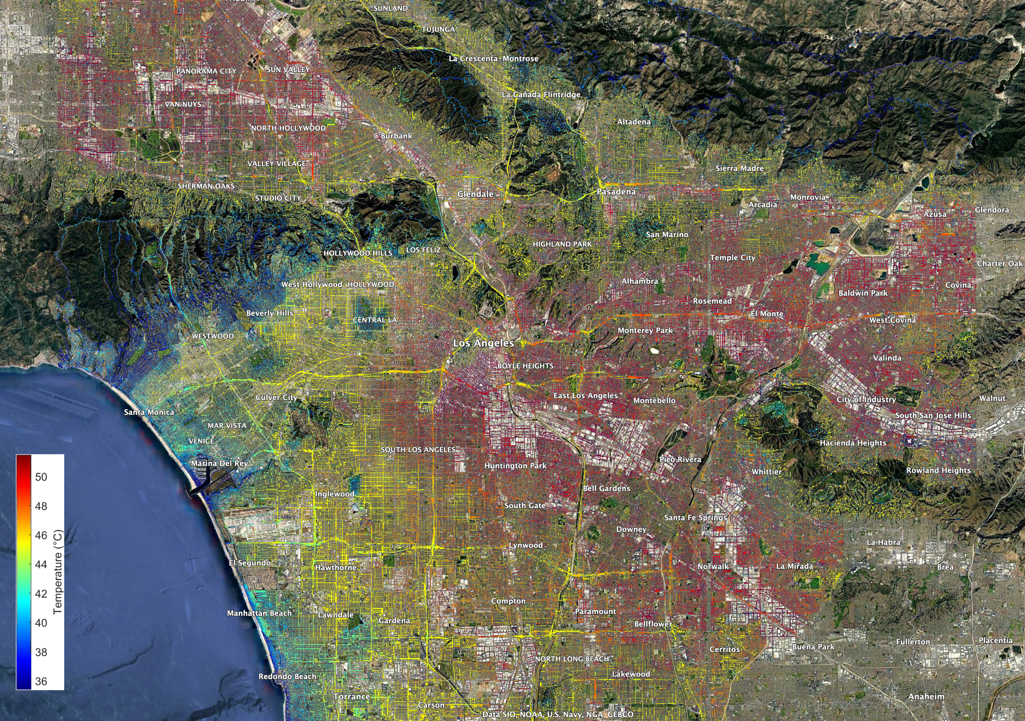
NASA’s ECOSTRESS Captures Short-Lived Heat Wave in L.A. Area
July 21, 2025
The heat lingered into the evening hours, as captured by NASA’s Ecosystem Spaceborne Thermal Radiometer Experiment on Space Station ( ECOSTRESS ) instrument. - read
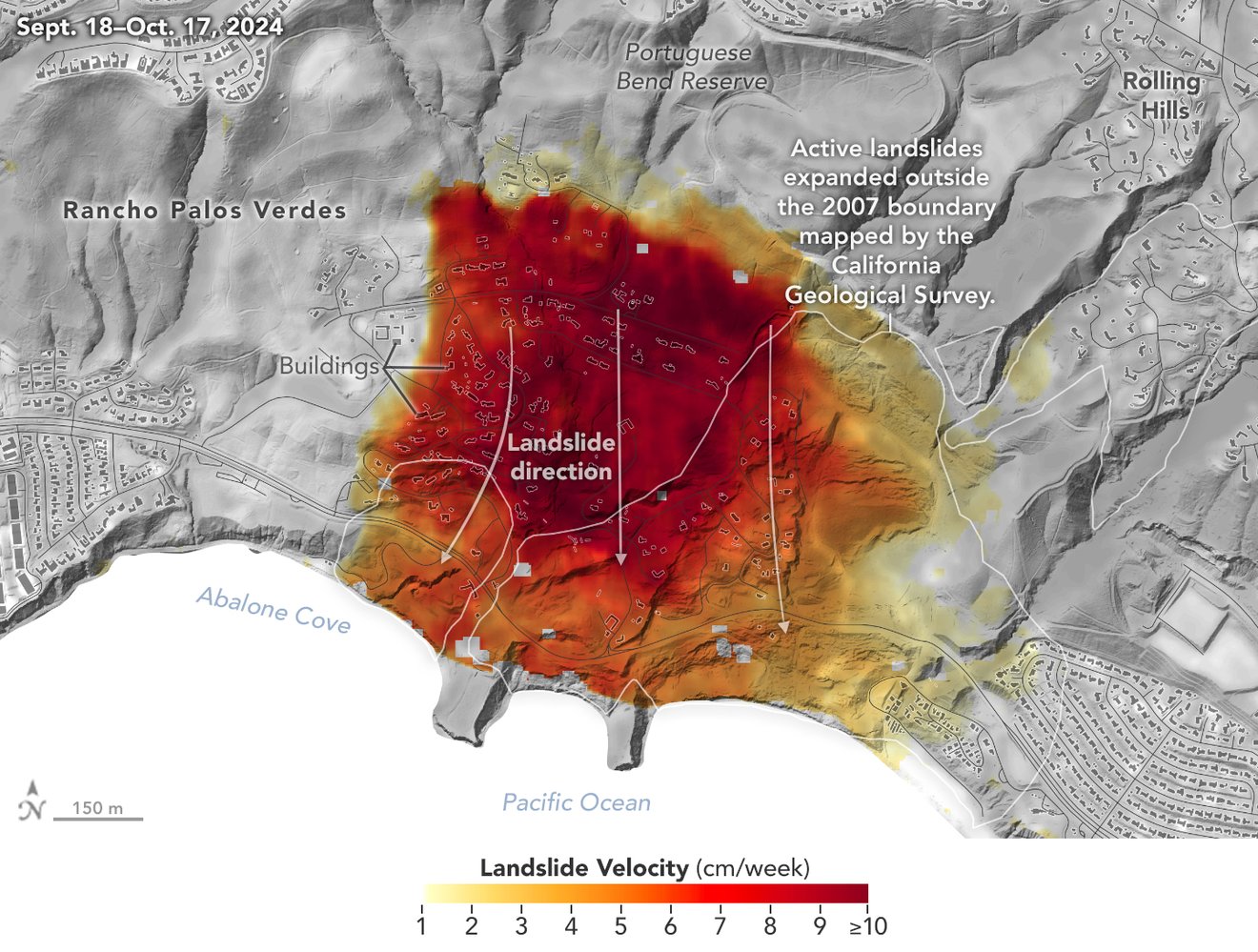
NASA’s UAVSAR airborne radar instrument captured data in fall 2024 showing the motion of landslides on the Palos Verdes Peninsula following record-breaking rainfall in Southern California in 2023 and another heavy-precipitation winter in 2024. Darker red indicates faster motion. Credit: NASA Earth Observatory read @nasa-jpl
 @CityOfLosAngeles
Regular City Council - 12/9/25 watch Climate Resilience Districts Overview and Approach PDF ::::::::: SMART_LA PDF / How Will LA Look in 2028? A Look at the City’s Plan To … pdf @cityoflosangeles @emit-sds smartla
Aquatic Report LinK @nasa-jpl inland glendale / hollyrock ; The Palisades ; Eaton Canyon @nasa-jpl @blackgirlscode @datadesk @stateofcalifornia @cbs-news-data @COBIS-HU hi latrice i cant look at tick tok yet im not ready for the news @CityOfLosAngeles @StateOFCalifornia @BlacakGirlsCode there is some way to get ms mitchell and Mayor Bass to see this link. They are really into climate data here Ms Hahn too @nasa-jpl
inducis [California - White Pages - Los Angeles Extended Area - June 1945 A through LANEG Los Angeles on Weather-gov Weather-gov api @blackgirlscode api GitHub
CryosPhere
CryosPhere\
January 8th 2025 Formaldehyde (HCHO)
Time Averaged Map of HCHO column amount daily 0.1 deg. [OMI OMHCHOd v003] molecules/cm^2 over 2025-01-01 - 2025-01-31
ime Averaged Map of Aerosol Single Scattering Albedo 483.5 nm daily 0.25 deg. [OMI OMAEROe v003] over 2025-01-01 - 2025-01-31
1 # HOLE_TO_ANOTHER_UNiVERSE##############################

@BlackGirLSCode Who is Brandy?########
1 # HOLE_TO_ANOTHER_UNiVERSE#####@NASA-JPL######hiCORAL###
2 # ### How Wildfire Looked Across @CityOfLosAngeles #####
3 # @StateOfCalifornia #`BrandyNorwood @BlackGirlsCode `##Upclose / Scene @vsco @emit-sds @NASA-DEVELOP MALiBU @CityOfLosangeles StateOfcalifornia
2 # ### How Wildfire looks across the continent ##############
3 # ANOTHER########`BrandyNorwood @BlackGirlsCode `Production#
+ @cityoflosangeles DEC 23-to-2025 JAN 14 FireActiity @stateofcalifornia .gif DOWNLOAD @nasa-jpl @emit-sds @TheSpaceDevs @BlueOrigin @r-spacex @NOAAgov
EatonCanyon
the mushy part is the burned property MAP @emit-sds @blackgirlscode

#EatonCanyonFire @CityOfLosAngeles
Supervisor Holly J. Mitchell archive.org/…/AV320250110t224555_002_L1B_RDN … Taken from #AViRiS DataPortAl / EarthDataSearch @PodaaC @NASA-GiSS @Nasa-JPL @Whitehouse
Due to wildfire evacuations, the Lab is closed, except for emergency personnel. No fire damage has been reported. Follow updates at https://t.co/yscOR5I3ys
— NASA JPL (@NASAJPL) January 8, 2025
Thanks to everyone for the concern for our center, but more importantly, for our colleagues and neighbors. Stay safe, LA. pic.twitter.com/Wjn02jlSyA


@TheSpaceDevs @BlueOrigin @NASA-PDS – @STATEOFCALiFORNiA @CiTYOFLOSANGELES @BLACKGiRLSCODE
EcoStress HeatMAp
DOWNLOAD_PDF:lacounty.gov/phn/docs/Emergency%20Preparedness%20Handouts.pdf KMZ @google @stateofcalifornia GoogleMaps @nasa-jpl @blackgirlscode
Eaton Fire aerial footage around Altadena
Watch on YOUTUBE ClickHere @emit-sds @theSpaceDevs @blackgirlscode 130,527 views Jan 8, 2025 The Eaton Fire burning north of Pasadena has burned about 1.6 square miles. Aerials around La Canada, Flintridge, and Altadena. Video from KABC, Jan. 8, 2025. @StateOfCalifornia @NOAA-OWP @blackgirlscode Read more: https://www.abc10.com/article/news/lo…
AVIRIS-ng 2025Wildfire arcgis 2025fire palisades @esri portal of disaster dataretrival : Rashard Kelly NasaEArthdata @nasa-pds @nasa-jpl @cityoflosangeles @blackgirlscode
GLifford Fire
2021 to 2025 Area Comparison 100% Contained 131,614 Acres 2 Counties: San Luis Obispo, Santa Barbara @StateOfCalifornia
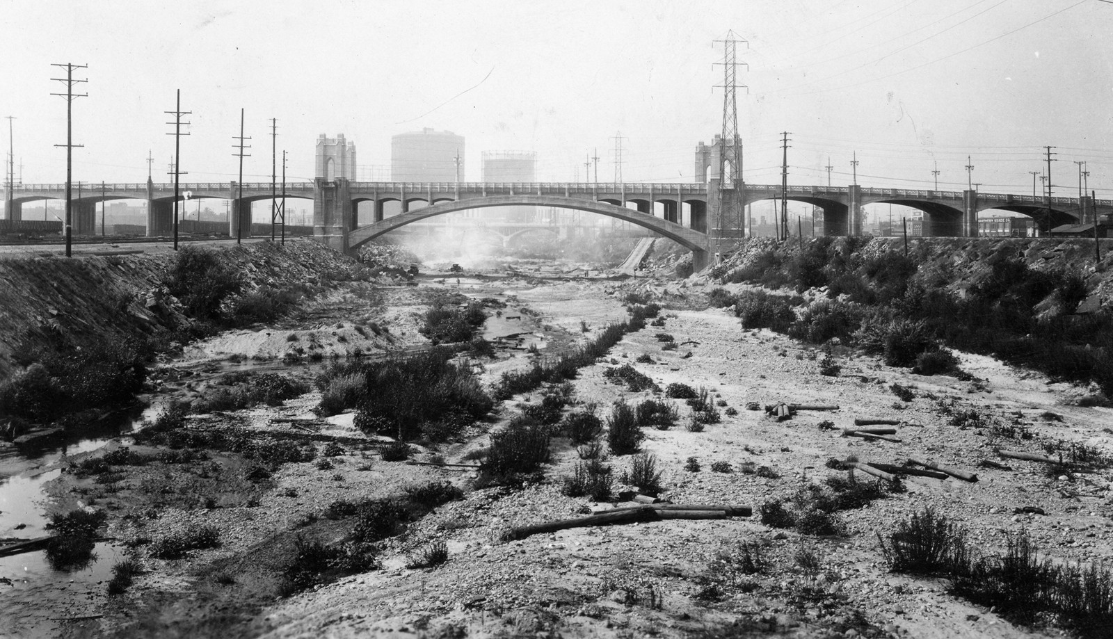
Los Angeles River - The Unpredictable! @ladwp history @blackgirlscode @podaac
![]() recovery.lacounty.gov
DamageMaps and more!
DisasterPlanning
NASA Disasters Mapping Portal
recovery.lacounty.gov
DamageMaps and more!
DisasterPlanning
NASA Disasters Mapping Portal
@cityoflosangeles @stateofcalifornia
FireFiles Commit bbceab2
Los Angeles Cryosphere
Time Averaged Map of Snow depth hourly 0.125 deg. [NLDAS Model NLDAS_NOAH0125_H v2.0] m
over 2025-11-15 00:00:00Z - 2025-11-17 23:00:00Z, Region 120.1575W, 31.0645N, 115.3674W, 35.2833N
News @CityOfLosAngeles @nasa-jpl
Rodney King riots officer says LA Mayor Karen Bass responded ‘too late’ to anti-ICE violence: ‘History is repeating’ A former Los Angeles police officer who was on duty during the 1992 Rodney King riots fears “history is repeating itself” as chaos continues over anti-ICE protests. Read Alex Oliveira
#EatonCanyonFire @CityOfLosAngeles
Supervisor Holly J. Mitchell archive.org/…/AV320250110t224555_002_L1B_RDN … Taken from #AViRiS DataPortAl / EarthDataSearch @PodaaC @NASA-GiSS @Nasa-JPL @Whitehouse
Due to wildfire evacuations, the Lab is closed, except for emergency personnel. No fire damage has been reported. Follow updates at https://t.co/yscOR5I3ys
— NASA JPL (@NASAJPL) January 8, 2025
Thanks to everyone for the concern for our center, but more importantly, for our colleagues and neighbors. Stay safe, LA. pic.twitter.com/Wjn02jlSyA
@TheSpaceDevs @BlueOrigin @NASA-PDS – @STATEOFCALiFORNiA @CiTYOFLOSANGELES @BLACKGiRLSCODE
EcoStress HeatMAp
DOWNLOAD_PDF:lacounty.gov/phn/docs/Emergency%20Preparedness%20Handouts.pdf KMZ @google @stateofcalifornia GoogleMaps @nasa-jpl @blackgirlscode

Eaton Fire aerial footage around Altadena
eo controls poster=”https://github.com/user-attachments/assets/58e6c43e-a3fb-43fc-a737-c3e319d0e4d5” >
</video>
Watch on YOUTUBE ClickHere @emit-sds @theSpaceDevs @blackgirlscode 130,527 views Jan 8, 2025 The Eaton Fire burning north of Pasadena has burned about 1.6 square miles. Aerials around La Canada, Flintridge, and Altadena. Video from KABC, Jan. 8, 2025. @StateOfCalifornia @NOAA-OWP @blackgirlscode Read more: https://www.abc10.com/article/news/lo…

DOWNLOAD_PDF:lacounty.gov/phn/docs/Emergency%20Preparedness%20Handouts.pdf
| Mapping surface water using Earth Engine (Floods, Water change, Seasonal Reservoirs) | Geo4Good ‘23 Surface water mapping using AI/ML Approaches of HYDRAFloods |
Deployment of SWOT’s Solar Arrays : WATCH READ
launched Dec. 16, 2022, at 3:46 a.m. PST from Vandenberg Space Force Base in California, and the arrays started their deployment at 5:01 a.m. PST.
#EatonCanyonFire @CityOfLosAngeles
@StateOfCalifornia KARENBASS @Cityoflosangeles @emit-sds I found a directory with what looks to be a vegitation index starting in 1981, los angeles has lost a lot of its luster and needs tlc! EarthDAta_LP_DAAC_ Index of VIP01.004: ::1981::: 1997 ;;; 2014 ……….
ALBEDO+NiGHTLiGHTS @blackgirlscode


@StateOfCalifornia KARENBASS @Cityoflosangeles @emit-sds I found a directory with what looks to be a vegitation index starting in 1981, los angeles has lost a lot of its luster and needs tlc! EarthDAta_LP_DAAC_ Index of VIP01.004: ::1981::: 1997 ;;; 2014 ……….
ALBEDO+NiGHTLiGHTS @blackgirlscode
My Japan by U.S. Treasury Department archive My Japan 1945 . m p 4 @jaxa @US-Department-of-the-Treasury @jaxa @deptofdefense @rashardsdata @meta post on fb @jaxa /// politics Our Enemy: The Japanese @jaxa @nasa @whitehouse @nasa-jpl @StateOfCalifornia @CityOFLosAngeles // @Jaxa im really a person at a humanist level that wants to be safe, i made many friend while in Jehovahs witneses, I forgot their names and im sure they wack people that fell off as well! But for those of you that enjoy life and discovery, i want to continue working together and build our trust in our intergalactic endevors… @TheSpaceDevs can you tell them Rashard Said That?

https://github.com/ThakaRashard/rashardmro/blob/master/_includes/EARINGTUESDAYNOVEMBER420251100AM.md
Eaton Fire aerial footage around Altadena
Watch on YOUTUBE ClickHere @emit-sds @theSpaceDevs @blackgirlscode 130,527 views Jan 8, 2025 The Eaton Fire burning north of Pasadena has burned about 1.6 square miles. Aerials around La Canada, Flintridge, and Altadena. Video from KABC, Jan. 8, 2025. @StateOfCalifornia @NOAA-OWP @blackgirlscode Read more: https://www.abc10.com/article/news/lo…
Jupiter Orbit Insertion Press Kit Mission Overview
EcoStress HeatMAp
KMZ @google @stateofcalifornia GoogleMaps @nasa-jpl @blackgirlscode
Los Angeleles SarView @cityoflosangeles
@whitehouse @asfadmin @nasa-jpl @emit-sds @blackgirlscode @stateofcalifornia
DOWNLOAD_PDF:lacounty.gov/phn/docs/Emergency%20Preparedness%20Handouts.pdf
Helvetica Trailer @blackgirlscode
Lost Boyz - Lifestyles Of The Rich And Shameless
Why is Mayor Karen Bass deleting her text messages?
L.A. Times sues city over Mayor Bass’ deleted text messages during fire response
The Los Angeles Times 1895-08-15
Pilot Episode I, Darrin, Take This Witch, Samantha S1E1 Bewitched
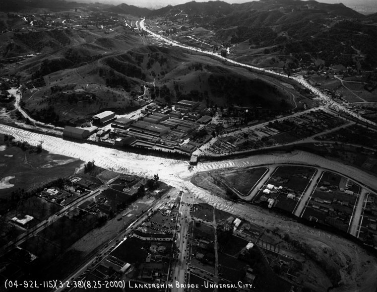
The Port of Los Angeles: a History
An illustrated history of Los Angeles County, California
LaHistoryArchive East Los Angeles : history of a barrio Front page : 100 years of the Los Angeles times, 1881-1981 The history of forgetting : Los Angeles and the erasure of memory
History of Los Angeles County, California, with illustrations descriptive of its scenery, residences, fine blocks and manufactories
El Pueblo de Nuestra Señora la Reina de los Ángeles del Río de Porciúncula (English: The town of Our Lady the Queen of the Angels of the River of the Porciuncula), shortened to Pueblo de los Ángeles, was the Spanish civilian pueblo settled in 1781, which became the American metropolis of Los Angeles. The pueblo was built using labor from the adjacent village of Yaanga and was totally dependent on local Indigenous labor for its survival
Read LaReina PDF related tweet WELCOME TO LA REINA The History of Los Angeles Historically, the areas of present day Los Angeles was home to the Chumash and Tongva Native American tribes. On September 4, 1781 a group of settlers consisting of 14 families numbering 44 individuals of Native American, African and European heritage journeyed more than one-thousand miles across the desert from present-day northern Mexico and established a farming community in the area naming it “El Pueblo de Nuestra Señora la Reina de los Ángeles de Porciúncula” which in English translated to “The Town of Our Lady the Queen of the Angels of Porciúncula”. Over time this community would grow under the flags of Spain, Mexico and eventually the United States to become one of the largest metropolitan cities in the world, the City of Los Angeles.
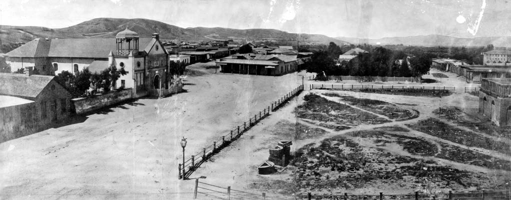 By Unknown author - https://tessa.lapl.org/cdm/search/searchterm/00032727, Public Domain, Link
Los Angeles Fires : Palisades : Pepperdine

FLiGHTLiNES.CSV Coast
Commit 4a8760a
#elnino @RepKarenBass @RealHWAtlanta @realDonaldTrump @normani pic.twitter.com/JXuedfs2zJ
— ThakaSartu KellySelassie (@thakasartu) January 30, 2025


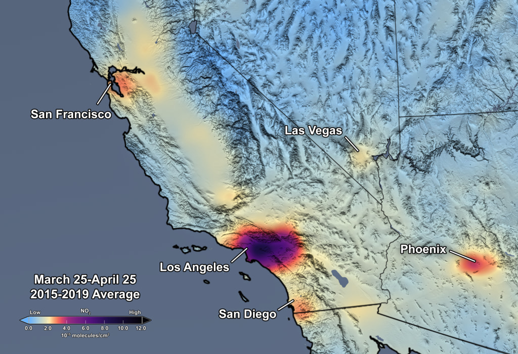
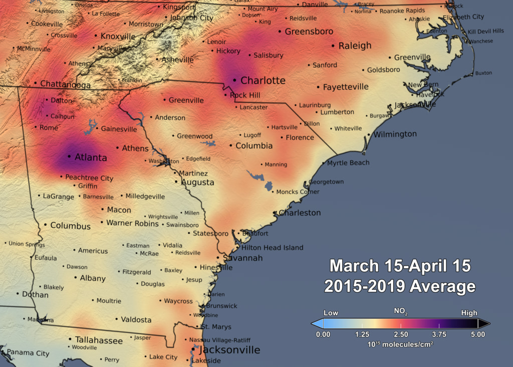
Nitrogen Dioxide over the Continental US and Los Angeles
Upon zooming into Southern California, finer details of pollution gradients are clearly visible over the Los Angeles/San Diego region. Here the concentration of NO2 is shown in shades of light blue to dark pink/purple indicating values ranging from low to high by CindyStarr Global Nitrogen Dioxide Monitoring Home Page @nasa @nasa-jpl @blackgirlscode @normani hi
Reductions in Pollution Associated with Decreased Fossil Fuel Use Resulting from COVID-19 Mitigation
Released Friday, April 24, 2020
Written by: Bryan Duncan Over the past several weeks, the United States has seen significant reductions in air pollution over its major metropolitan areas. Similar reductions in air pollution have been observed in other regions of the world. READMORE Released Friday, April 24, 2020


GRACE and GRACE-FO track California’s land water changes
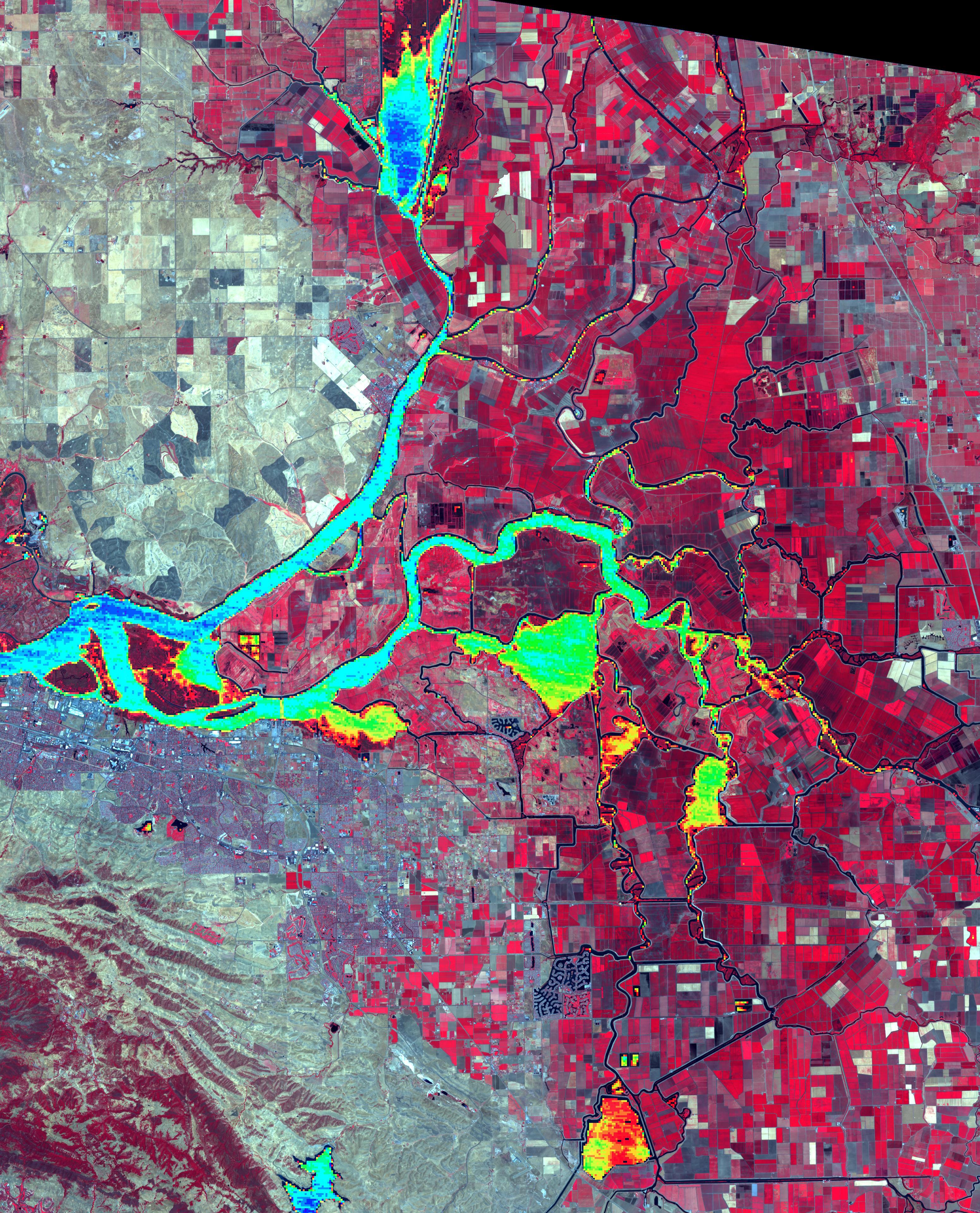
NASA’s Gravity Recovery and Climate Experiment (GRACE, 2002 - 2017) mission, and its successor GRACE Follow-On (launched in 2018), map month-to-month changes in Earth’s gravity field resulting from the movement of mass, such as water, near the surface of the planet. This animation shows how the total amount of water (snow, surface water, soil moisture, and groundwater) varies in space and time, with the passage of dry seasons and wet seasons as well as with flooding, drought, and transport due to water management. Blue colors represent wetter than average conditions (relative to 2004-2010), while red colors represent drier than average conditions. The yellow line in the graph on the left shows the evolution of the long-term inter-annual variations for the area outlined in yellow on the map (note: the average seasonal cycle has been removed).
The Sacramento and San Joaquin River basins are outlined in yellow, and rivers and tributaries are shown as blue lines. The basins include California’s Central Valley, the most productive agricultural region in the U.S. Repeated drought conditions and increased water use in California have led to a long-term decline of terrestrial water, interspersed with above-average precipitation periods (e.g., 2015/2016, 2022/2023) that have allowed some recovery of the land water storage.
Credit NASA / JPL
Science On a Sphere: 4 Years of Biosphere
RelatedTweet
By monitoring the color of reflected light via satellite, scientists can determine how successfully plant life is photosynthesizing. A measurement of photosynthesis is essentially a measurement of successful growth, and growth means successful use of ambient carbon. This data visualization represents four years’ worth of data taken primarily by Suomi NPP/VIIRS satellite sensors, showing the abundance of life both on land and in the seaREADMORE


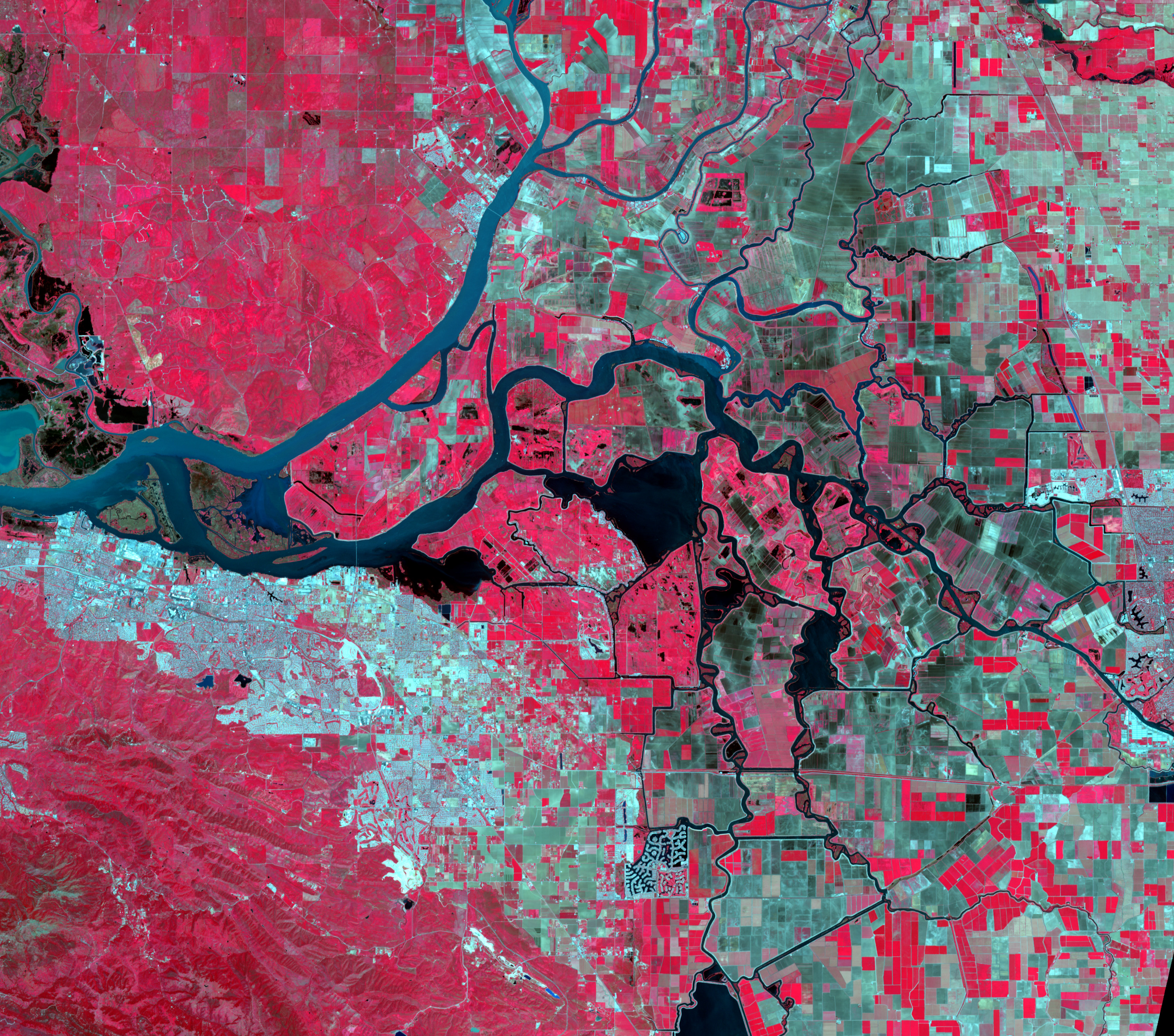
Levee Break Floods Central California Related
Gavin NEwsome
I left a tweet on your housefloor meeting
@usepa @nasa-jpl @usgs
EPA + WATER MAPS
NASA WORLDViEW Mar12 USGS WATERDASHBOARD Mar12

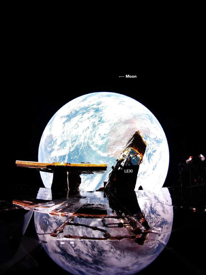
A Small Blue-Gray Marble
A digital camera on the Blue Ghost lander looked back at Earth and captured this ethereal image. - NASA VisiBLEEARTH FireFlyAeroSpace
DSCOVR: EPIC
LAst Update 7/15
@nasa-jpl @nasa-pds @podaac i went into detail on facebook. @nasa-pds and included @Harvard and Noaa @avanderburg @fbecerra
There are files after #JULY15 but i did not see anything obviouse about #ImagingData this #gzip is from #July25th many of the datasources are blank, Since the thing is broaDCASTING Chief Master Sergeant of the Space Force Bill Nelson Congressmember Karen Bass im just trying to get eyes on the issue
### Start Date End Date Data Type Processing
Environment Processing Date Filesize
2025-07-12T00:00:00Z 2025-07-12T23:59:59Z Faraday Cup L1 data OE 2025-07-13T02:20:03Z 0.33 MB
2025-07-12T00:00:00Z 2025-07-12T23:59:59Z Stored Observatory Telemetry OE 2025-07-13T00:00:11Z 34.85 MB
2025-07-12T00:00:00Z 2025-07-12T23:59:59Z Magnetometer L0 data OE 2025-07-13T01:01:00Z 34.50 MB
2025-07-27T00:00:00Z 2025-07-27T23:59:59Z Faraday Cup L1 data OE 2025-07-28T01:02:33Z 0.00 MB
2025-07-28T00:00:00Z 2025-07-28T23:59:59Z Faraday Cup L1 data OE 2025-07-29T01:02:34Z 0.00 MB
2025-07-28T00:00:00Z 2025-07-28T23:59:59Z Faraday Cup L0 data OE 2025-07-29T01:02:18Z 0.00 MB
2025-07-28T00:00:00Z 2025-07-28T23:59:59Z Magnetometer L0 data OE 2025-07-29T01:01:00Z 0.00 MB
2025-07-28T00:00:00Z 2025-07-28T23:59:59Z Stored Observatory Telemetry OE 2025-07-29T00:00:10Z 0.00
See the Pen WebSafeFontSampler @normani by ricoThaka (@ricoThaka) on CodePen.
Los Angeles-Area Landslide Expands
ReadMore @CityOfLosangeles @nasa-jpl @blackgirlscode
@cityoflosangeles FUTURE+PERCiPiTATiON- interactive MAp
@Cityoflosangeles CHLOROPHYLL @nasa-jpl theres a big smear here, im almost done with my report
Coordinates: 33.8313°, -118.1745°
California
Resivoirs, Dams, Settlements Interactive Modifyable - @nasa MAP
BASEMAP : VIIRS/NPP Gap-Filled Lunar BRDF-Adjusted Nighttime Lights Daily L3 Global 15 arc-second Linear Lat Lon Grid NRT
ViiRS = Visible Infrared Imaging Radiometer Suite State:OPERATiONAL @Cityoflosangeles LocalLinuxGroup
@StateOfCalifornia … @emit-sds @nasa-jpl
Los Angeles StandingWater/Chlorophyll spots
The U.S. government is closed. However, because the information this website provides is necessary to protect life and property, this site will be updated and maintained during the federal government shutdown. For the latest forecasts and critical weather information, visit www.weather.gov.To learn more, visit commerce.gov. Automated data processing will continue to populate this site provided services do not require manual intervention. @nasa-jpl @nasa-develop
STREAM + CHLOROPHYLL-a Sentinel
[Los Angeles Area Protected Areas] MAP
LinkToMap @usgs @stateofcalifornia
FireNews @nasa-jpl @blackgirlscode
Solid Steel (1st June) This week we welcome back Prefuse 73
Los Angeles Area Land Displacement
[Try This Harmonized Landsat Sentinel-2 product Map] OperaLandDisturbanceMap
The Los Angeles City Hall, Calif. STEREOGRAPH LA 92 LA92 Alt LA92 Panel - Live National Geographic LA Stories: The 1992 Riots That Shook the City “ WATTS RIOT OR REVOLT? ” AUGUST, 1965 WATTS, LOS ANGELES RACE RIOTS SPECIAL REPORT PART 1 SM10075a “A CITY AND ITS PEOPLE “ A DAY IN 1960s LOS ANGELES CALIFORNIA EDUCATIONAL FILM XD72474
@StateOfCalifornia KARENBASS @Cityoflosangeles @emit-sds I found a directory with what looks to be a vegitation index starting in 1981, los angeles has lost a lot of its luster and needs tlc! EarthDAta_LP_DAAC_ Index of VIP01.004: ::1981::: 1997 ;;; 2014 ……….
ALBEDO+NiGHTLiGHTS @blackgirlscode
OLD NEWS
- READ @cityoflosangeles Los Angeles Wildfires Disrupting DAAC Operations and Data Access NASA’s Physical Oceanography Distributed Active Archive Center (PO.DAAC) and Jet Propulsion Laboratory (JPL) are experiencing operational outages that may affect data processing.
- Fires Tear Through Los Angeles READ
- California deploys cutting-edge technologies for LA fires recovery with expanded NASA Jet Propulsion Laboratory partnership READ
- NASA’s ARIA Maps California Wildfires from Space READ @nasa-jpl
-
Los Angelels SarView
@blackgirlscode + fb @nasa-jpl @nasa-pds
Caltrans Encampment Resource Network Tutorial + MAP @cagov culvercity.gov @stateofcalifornia Encampment Resolution stream eosdis.nasa.gov
My Japan by U.S. Treasury Department archive My Japan 1945 . m p 4 @jaxa @US-Department-of-the-Treasury @jaxa @deptofdefense @rashardsdata @meta post on fb @jaxa /// politics Our Enemy: The Japanese @jaxa @nasa @whitehouse @nasa-jpl @StateOfCalifornia @CityOFLosAngeles // @Jaxa im really a person at a humanist level that wants to be safe, i made many friend while in Jehovahs witneses, I forgot their names and im sure they wack people that fell off as well! But for those of you that enjoy life and discovery, i want to continue working together and build our trust in our intergalactic endevors… @TheSpaceDevs can you tell them Rashard Said That?
ThX @mattgraham aka #KEViNROTHWELL! ʕ •ᴥ•ʔ


 @cityoflosangeles @stateofcalifornia
Federal Housing Administration Insured Single Family Properties in Force
MAyor Karen! I am still working on My @nasa Login I still need to make a support ticket for my secret question answers, that was 2015, my thinking has not chnaged much butn routines have and i cant remember spelling or formatting from that era consistantly! I Know you need maps so there is a map @ersi ArchGis has with census data, I shared SEDAC with you but.. well im just disappointed that its hard to carry sessions when you have to start from scratch everytimg. But im working on my workflow methods
Monitoring L.A. : Digital Assets
We kicked things off in style yesterday! Take a peek at the excitement from Day 1 of our #NWC2025! 🎉 #nagios pic.twitter.com/0SOSWo0JrR
— Nagios (@nagiosinc) October 1, 2025

Dear @NASA-PDS / @NASA-JPL
@whitehouse @dhs-gov @nasa
Colors #FiCtiONDRAMAREALiTY plot;tourist hurting locals imdb A police veteran and his rookie partner fight Los Angeles gangs.
Related doc Graffiti_VeriteVOL1
| Mapping surface water using Earth Engine (Floods, Water change, Seasonal Reservoirs) | Geo4Good ‘23 Surface water mapping using AI/ML Approaches of HYDRAFloods |
Deployment of SWOT’s Solar Arrays : WATCH READ
launched Dec. 16, 2022, at 3:46 a.m. PST from Vandenberg Space Force Base in California, and the arrays started their deployment at 5:01 a.m. PST.

LAFD thought the fire in the Palisades on Jan. 1 was out. It didn’t use thermal imaging to confirm @datadesk this is @nasa-jpl `12:23 PM · Jan 8, 2025 · 106.1K @CiTYOFLOSANGELES @EMiT-SDS @NASA-DEVELOP @NASA-PDS Views https://x.com/NASAJPL/status/1877088825383460977 @emit-sds
yo Congressmember Karen Bass i was doxxed there is an article defaming LAFD South Bureau #LAFD that they were not using Vital Tool to confirm #Jan1 fire was out, i think i started working the issue on the 8th https://rashardsdata.github.io/c…/The-2025-Los-Angeles-Fires Normani was backing me up in vvarious ways she has to talk NASA’s Europa Clipper Mission NASA’s Perseverance Mars Rover the library was not cooperative Los Angeles Times now if you fuckin with karen rep like that start at the library with her present @whitehouse @cityoflosangeles @libraryofcongress HAnnaFry
National Park Service CONTINGENCY PLAN ///// Mapping and Identifying the Health of Urban Oak Trees in Los Angeles County @stateofcalifornia @cityoflosangeles via ECOSTRESS
In fire-scorched Palisades, a library and rec center become linchpins of fury with City Hall
@blackgirlscode If you have work from the fires be sure to organize it
Due to wildfire evacuations, the Lab is closed, except for emergency personnel. No fire damage has been reported. Follow updates at https://t.co/yscOR5I3ys
— NASA JPL (@NASAJPL) January 8, 2025
Thanks to everyone for the concern for our center, but more importantly, for our colleagues and neighbors. Stay safe, LA. pic.twitter.com/Wjn02jlSyA
 <~ @blackgirlscode i hope u guys ok on github!
@CiTYoFLosAngeles @NAsa-jpl I went to the bike festival, I stopped by Ms Bass tent and told them What Jamie Told me that I was a member of the local helpdesk team at mission control and you guys told me to make friends with congress in the city. I did not mention the girls! However i let them know that they are not getting the support that they wanted because the sex tourist are ruining my life at every opportunity. i wanted to Talk FireSensing technology with YSABEL JURADO because the work i was doing during the fires of January using NasaEarthData FireSensing Products and i left my blog rashardsdata with an AntiTrumpGroup and told them that if they scard of @Whitehouse President Trump is scary to them they can look at myBlog to find out what he has me tasked with, it was in hiearical context so like we work with the machine and thats the highest point on our SLA Agreements with @Deptdefense / @Whitehouse
[NSSC Service Level Agreement Fiscal Year (FY) 2025 Effective: October 1, 2024] download
Censord FacebookPosts
@blackgirlscode @meta @nasa-jpl there is a wardrobe malfuntion photo some group the artist known as normani shared on ukdaily news im afraid to look at the link because people use it as a excuse to say we cant talk!!!!!!!!!! im so exhausted and abused!!!!
This goes against our Community Standards on cybersecurity.
https://rashardgds.github.io/ricotha
@[100064688230749:2048:U.S. Department of War] this page got my account deleted @[100057616226973:2048:Supervisor Holly J.
MAPPiNG @CityOfLosAngles Trees @StateOfCalifornia
      ___    _____     ___
    /_ /|  /____/ \  /_ /|       Horizons On-line Ephemeris System v4.98d
    | | | |  __ \ /| | | |       Solar System Dynamics Group
 ___| | | | |__) |/  | | |__     Jet Propulsion Laboratory
/___| | | |  ___/    | |/__ /|   Pasadena, CA, USA
|_____|/  |_|/       |_____|/
@cityoflosangeles @stateofcalifornia @nasa @whitehouse 3 2 - see comments 3
@blackgirlscode anime fb TheMAxx
DSCOVR: EPIC
LAst Update 7/15
@nasa-jpl @nasa-pds @podaac i went into detail on facebook. @nasa-pds and included @Harvard and Noaa @avanderburg @fbecerra
There are files after #JULY15 but i did not see anything obviouse about #ImagingData this #gzip is from #July25th many of the datasources are blank, Since the thing is broaDCASTING Chief Master Sergeant of the Space Force Bill Nelson Congressmember Karen Bass im just trying to get eyes on the issue
### Start Date End Date Data Type Processing
Environment Processing Date Filesize
2025-07-12T00:00:00Z 2025-07-12T23:59:59Z Faraday Cup L1 data OE 2025-07-13T02:20:03Z 0.33 MB
2025-07-12T00:00:00Z 2025-07-12T23:59:59Z Stored Observatory Telemetry OE 2025-07-13T00:00:11Z 34.85 MB
2025-07-12T00:00:00Z 2025-07-12T23:59:59Z Magnetometer L0 data OE 2025-07-13T01:01:00Z 34.50 MB
2025-07-27T00:00:00Z 2025-07-27T23:59:59Z Faraday Cup L1 data OE 2025-07-28T01:02:33Z 0.00 MB
2025-07-28T00:00:00Z 2025-07-28T23:59:59Z Faraday Cup L1 data OE 2025-07-29T01:02:34Z 0.00 MB
2025-07-28T00:00:00Z 2025-07-28T23:59:59Z Faraday Cup L0 data OE 2025-07-29T01:02:18Z 0.00 MB
2025-07-28T00:00:00Z 2025-07-28T23:59:59Z Magnetometer L0 data OE 2025-07-29T01:01:00Z 0.00 MB
2025-07-28T00:00:00Z 2025-07-28T23:59:59Z Stored Observatory Telemetry OE 2025-07-29T00:00:10Z 0.00
See the Pen WebSafeFontSampler @normani by ricoThaka (@ricoThaka) on CodePen.
Los Angeles-Area Landslide Expands
ReadMore @CityOfLosangeles @nasa-jpl @blackgirlscode
@cityoflosangeles FUTURE+PERCiPiTATiON- interactive MAp
@Cityoflosangeles CHLOROPHYLL @nasa-jpl theres a big smear here, im almost done with my report
Coordinates: 33.8313°, -118.1745°
California
Resivoirs, Dams, Settlements Interactive Modifyable - @nasa MAP
BASEMAP : VIIRS/NPP Gap-Filled Lunar BRDF-Adjusted Nighttime Lights Daily L3 Global 15 arc-second Linear Lat Lon Grid NRT
ViiRS = Visible Infrared Imaging Radiometer Suite State:OPERATiONAL @Cityoflosangeles LocalLinuxGroup
@StateOfCalifornia … @emit-sds @nasa-jpl
Los Angeles StandingWater/Chlorophyll spots
The U.S. government is closed. However, because the information this website provides is necessary to protect life and property, this site will be updated and maintained during the federal government shutdown. For the latest forecasts and critical weather information, visit www.weather.gov.To learn more, visit commerce.gov. Automated data processing will continue to populate this site provided services do not require manual intervention. @nasa-jpl @nasa-develop
STREAM + CHLOROPHYLL-a Sentinel
[Los Angeles Area Protected Areas] MAP
LinkToMap @usgs @stateofcalifornia
FireNews @nasa-jpl @blackgirlscode
Solid Steel (1st June) This week we welcome back Prefuse 73
Los Angeles Area Land Displacement
[Try This Harmonized Landsat Sentinel-2 product Map] OperaLandDisturbanceMap
OLD NEWS
- READ @cityoflosangeles Los Angeles Wildfires Disrupting DAAC Operations and Data Access NASA’s Physical Oceanography Distributed Active Archive Center (PO.DAAC) and Jet Propulsion Laboratory (JPL) are experiencing operational outages that may affect data processing.
- Fires Tear Through Los Angeles READ
- California deploys cutting-edge technologies for LA fires recovery with expanded NASA Jet Propulsion Laboratory partnership READ
- NASA’s ARIA Maps California Wildfires from Space READ @nasa-jpl
-
Los Angelels SarView
@blackgirlscode + fb @nasa-jpl @nasa-pds
Caltrans Encampment Resource Network Tutorial + MAP @cagov culvercity.gov @stateofcalifornia Encampment Resolution stream eosdis.nasa.gov
The Los Angeles City Hall, Calif. STEREOGRAPH LA 92 LA92 Alt LA92 Panel - Live National Geographic LA Stories: The 1992 Riots That Shook the City “ WATTS RIOT OR REVOLT? ” AUGUST, 1965 WATTS, LOS ANGELES RACE RIOTS SPECIAL REPORT PART 1 SM10075a “A CITY AND ITS PEOPLE “ A DAY IN 1960s LOS ANGELES CALIFORNIA EDUCATIONAL FILM XD72474
Dear MAyor (Karen Bass)
Hi, Its Rasahrd from NasaJpl the YA Somali that takes short naps on the back portch of city hall. I am following your instructions in the County of Los Angeles Emergency Survival Guide
it reads
This Guide will help you to better prepare for, respond to and recover from disasters that face Los Angeles County. Our goal is to provide tips that assist you to be self-sufficient after a disaster

Its hard to explin everything in one quick note. But basically I was in Atlanta and My Wife Vanished and i got destituted by ppl throwing me in the mental hospital a girl i was told was my cousin Kelly Danielle Renee Williams daughter by Winfred. My daughter was taken and i cannot even get a cellphone.
I eat at St_Francis once a day and Reality Church in Hollywood 5 days a week since i got suspended from Long Beach’s Billie Jean Library… So i need you to look at this conversation. Its the kidnapper of my wife#2/3 She is no longer you wife
im always running from ppl bc she is in the entertainment industry. They have an infrastructure that cuts the girls off from contact outside a Streaming Media Cult
anyway last night June 9th a gaurd with Allied Universal The guy with scruffy hair. Hes white he called this South American Assasin and he cahsed me with a holstered gun and bullet proof Tactical Vest out of the subway
Los Angeles 1940s in Color! Driving Downtown w/sound design added California 1950s, Driving Wilshire Blvd in color w/sound design added
The Los Angeles Times 1895-08-15
Normani - Insomnia (Audio) Normani - Still (Audio) Pilot Episode I, Darrin, Take This Witch, Samantha S1E1 Bewitched
The Port of Los Angeles: a History
An illustrated history of Los Angeles County, California
LaHistoryArchive East Los Angeles : history of a barrio Front page : 100 years of the Los Angeles times, 1881-1981 The history of forgetting : Los Angeles and the erasure of memory
History of Los Angeles County, California, with illustrations descriptive of its scenery, residences, fine blocks and manufactories
El Pueblo de Nuestra Señora la Reina de los Ángeles del Río de Porciúncula (English: The town of Our Lady the Queen of the Angels of the River of the Porciuncula), shortened to Pueblo de los Ángeles, was the Spanish civilian pueblo settled in 1781, which became the American metropolis of Los Angeles. The pueblo was built using labor from the adjacent village of Yaanga and was totally dependent on local Indigenous labor for its survival
Read LaReina PDF related tweet WELCOME TO LA REINA The History of Los Angeles Historically, the areas of present day Los Angeles was home to the Chumash and Tongva Native American tribes. On September 4, 1781 a group of settlers consisting of 14 families numbering 44 individuals of Native American, African and European heritage journeyed more than one-thousand miles across the desert from present-day northern Mexico and established a farming community in the area naming it “El Pueblo de Nuestra Señora la Reina de los Ángeles de Porciúncula” which in English translated to “The Town of Our Lady the Queen of the Angels of Porciúncula”. Over time this community would grow under the flags of Spain, Mexico and eventually the United States to become one of the largest metropolitan cities in the world, the City of Los Angeles.
By Unknown author - https://tessa.lapl.org/cdm/search/searchterm/00032727, Public Domain, Link

TCL formerly Mann’s Chinese Theater

How Internet Traffic works (Warriors of the Net).mp4 https://archive.org/download/ComputerHackingDocumentriesMegaCollection

Dear MAyor (Karen Bass)
Allied Filling Jobs
LA Local News Judge Orders Arbitration of Allied Security Guard’s Harassment Suit]
BMO Stadium selects Allied Universal as preferred event services provider
Allied Universal to hire 450 security officers, mostly in LA County
 BODY ARMOR FOR THE SECURITY INDUSTRY

Proposition 64: The Adult Use of Marijuana Act
Overview The California Cannabis Hemp Initiative of 2014 Effective November 9, 2016, Proposition 64 legalizes specified personal use and cultivation of marijuana for adults 21 years of age or older; reduces criminal penalties for specified marijuana-related offenses for adults and juveniles; and authorizes resentencing or dismissal and sealing of prior, eligible marijuana-related convictions. The proposition includes provisions on regulation, licensing, and taxation of legalized use. California Courts Proposition 64 and Responsible Adult Use of Marijuana LA_COUNTY California MEDICAL MARIJUANA IDENTIFICATION CARD PROGRAM Proposition 64 (Marijuana Offenses) FAQ [SanDieago] Proposition 64 - Personal Non-Medical Use of Cannabis Brea California Prop 64 FAQs San Francisco Prop64 FAQ When does Proposition 64 take effect? Proposition 64 took effect November 9, 2016. You can and should seek relief right away. prop64 Marijuana Initiative Enters Circulation Medicinal Cannabis: History, Pharmacology, And Implications for the Acute Care Setting Congress quietly ends federal government’s ban on medical marijuana
DOWNLOAD~MARIJUANA LEGALIZATION. INITIATIVE STATUTE Proposition64
Gangstarr - Moment_0f_Truth FULL ALBUM Shaakira_Gathers_iLoveu
Heath cliff and the Cadillac cats episodes + Heathcliff (animated flick)
WildFireS


Los Angeles
hole to another universe

Frank Lloyd Wright Sr. (June 8, 1867 – April 9, 1959) was an American architect, designer, writer, and educator. He designed more than 1,000 structures over a creative period of 70 years. Wright played a key role in the architectural movements of the twentieth century, influencing architects worldwide through his works and mentoring hundreds of apprentices in his Taliesin Fellowship.[1][2] Wright believed in designing in harmony with humanity and the environment, a philosophy he called organic architecture. Hollyhock House, 4800 Hollywood Boulevard, Los Angeles, Los Angeles County, CA


This philosophy was exemplified in Fallingwater (1935), which has been called “the best all-time work of American architecture” WikiPedia MoMA

 Frank Lloyd Wright’s Fallingwater: Inside the House That Forever Changed Architecture
Seal of Los Angeles County, California
 Expedition 66 Astronaut Tom Marshburn Answers Los Angeles Student Questions - March 21, 2022
Aboard the International Space Station, NASA Expedition 66 Flight Engineer Tom Marshburn answered pre-recorded questions about life and work on the orbital laboratory during an in-flight event March 21 with the Orville Wright STEAM Middle School in Las Angeles, California. Marshburn is in the midst of a planned six-month mission living and working aboard the microgravity laboratory to advance scientific knowledge and demonstrate new technologies for future human and robotic exploration missions as part of NASA’s Moon and Mars exploration approach, including lunar missions through NASA’s Artemis program. Orville Wright
Expedition 66 Astronaut Tom Marshburn Answers Los Angeles Student Questions - March 21, 2022
Aboard the International Space Station, NASA Expedition 66 Flight Engineer Tom Marshburn answered pre-recorded questions about life and work on the orbital laboratory during an in-flight event March 21 with the Orville Wright STEAM Middle School in Las Angeles, California. Marshburn is in the midst of a planned six-month mission living and working aboard the microgravity laboratory to advance scientific knowledge and demonstrate new technologies for future human and robotic exploration missions as part of NASA’s Moon and Mars exploration approach, including lunar missions through NASA’s Artemis program. Orville Wright
Mapping Makes an Impact in the Fight to Reduce Child Exploitation The surreptitious nature of child sex trafficking, with offenders keeping children on the move and crossing jurisdictional lines, makes it difficult to locate and protect children and track down those who exploit them. The National Center for Missing & Exploited Children (NCMEC) takes a data-centric approach that empowers cross-agency collaboration. Esri_BLOG
Cambodian Genocide In 1975, a communist regime known as the Khmer Rouge conquered the Cambodian capital of Phnom Penh. The occupation set in motion a four-year campaign of genocide that would wipe out 2 million people – a quarter of the country’s population. Developed through a partnership between USC Shoah Foundation and the Documentation Center of Cambodia, the Cambodian Genocide Collection offers testimonies of survivors who escaped the killings from 1975 to 1979…ReadMoreatUSC

UrbanTypeface or Fashion ?

![]()
Divide and Conquer (film)
Divide and Conquer (1943) is the third film of Frank Capra’s Why We Fight propaganda film series and deals with the Nazi conquest of Western Europe in 1940. ReadMoreOnWikiPedia
Divide and Conquer
Divide and rule policy (Latin: divide et impera), or divide and conquer, in politics and sociology is gaining and maintaining power divisively. This includes the exploitation of existing divisions within a political group by its political opponents, and also the deliberate creation or strengthening of such divisions.
The strategy, but not the phrase, applies in many ancient cases: the example of Aulus Gabinius exists, parting the Jewish nation into five conventions, reported by Flavius Josephus in Book I, 169–170 of The Jewish War (De bello Judaico).[1] Strabo also reports in Geographica, 8.7.3[2] that the Achaean League was gradually dissolved when it became part of the Roman province of Macedonia, as the Romans treated the various states differently, wishing to preserve some and to destroy others.[citation needed]
Elements of this technique involve: [citation needed]
creating or encouraging divisions among the subjects to prevent alliances that could challenge the sovereign and distributing forces so that they overpower each other. aiding and promoting those who are willing to cooperate with the sovereign fostering distrust and enmity between local rulers encouraging meaningless expenditures that reduce the capability for political and military spending Read<oreOnWikiPedia imdb
Murphy Ranch Road Trail Murphy’s Ranch: Abandoned Nazi Camp in Santa Monica
