@nasa-jpl im working on some online learning, ill be back to arset . . . i need to knock some of these out . . . Im learning CommandLineGit simultaneously @git @blackgirlscode rostered @la-county-isd HollyJMitCHELL @officialredhat LearningLAb @podaac @nasa @stateofcalifornia @nasa-pds
GM @blackgirlscode LatriceFitzPatrick, btw your results changed and i dont see you in your business suit in my @google results. Its less distracting, but i cant say i dont miss seeing your glory my queen, dismiss me please, you bout to hurt me, i still have not shaved as you requested and i need some confirmation ok! @mdn is a good resource for you guys @howard-university-web-services, if normani is still on that radio share thing tell her im listening to weFunkHowardWebStandardsMoZiLLADev and also FireFox [1 is our standard browser @nasa-jpl, we build it using SunCompilersandroid : Nightlybeta … @la-county-isd @CityOfLosAngeles @StateOfCalifornia just a little insight into our infrastructure @podaac @nasa-jpl /// @nasa-develop @Nasa-giss LATRiCE! please follow The Small Business Administration on Github @USSBA, That department was discussed in a @Nasa TownHall meeting, just because im @Nasa-Openscapes EarthData dont mean i claim them people quick, i never talked to Mori directly again @usnavy i might be in the navy and not know it, i got a pdf from spaceForce @USSF-ORBIT @nbcnews
Accountant Latrice Fitzpatrick , the founder of Virtiserv, said she always suggests spending money in a way that can make more money. - wkbn.com @blackgirlscode
NASA Office of Small Business Programs
The mission of the NASA Office of Small Business Programs is to promote and integrate small businesses into the industrial base of contractors and subcontractors that support the future of space exploration, scientific discovery, and aeronautics research. EXPLORE - nasa.gov/osbp/ @blackgirlscode @ajcnews @webb hi @dishpanda i just wanted to share this townhall with entreprenures
@Blackgirlscode at one point Tinashe was talking to me and i made her a pages blog, if thats glorilla / Latrice Fiz Patrick here is a link https://thakarashard.github.io/BUBBLEGUMPOP_TiNASHE/
@nasa-jpl i can get shut down because some of them were on sale in hollywood please protect my link, they asked me to so its like a law enforcement thing becasue they were doxxed and people got fired. I got fired, which slowed my return from atlanta but several of the girls at Dance411 lost thier jobs @la-county-isd Holly_J_Mitchell [1] [2] they are good with compputers and got sabotaged a lot on the way out west @CityOfLosAngeles its a template i developed when @pintrest was under attack @deptofdefense
Remember alot of the grls are in burlesque to this day so if you talk to a social company answers and results can vary but i was clean with them @whitehouse MrTrump. By The Way, I have two videos I want you to see about Quality OF life in LosAngeles and the priority of Art, Graffiti and Going HAm
rashardgds was like 65 -100 commits behind on the pages repo, this mro repo is a template clone so its not attached to the main fork and never updates, I dont know a clean way to update a new head , i really dont know what i did, blogging is so realtime @blackgirlscode
Name: nasa.gov
Registry Domain ID: DF12B2D9A-GOV
Domain Status:
serverTransferProhibited

Nameservers:
a1-32.akam.net

a12-64.akam.net

a14-67.akam.net

a5-66.akam.net

a8-66.akam.net

a9-64.akam.net

Dates
Registry Expiration: 2026-07-31 14:55:32 UTC
Updated: 2025-09-07 18:35:13 UTC
Created: 1997-10-02 01:29:26 UTC
>EXACT< name search [SPACE sensitive]:
NAME = artimis;
Continue [ <cr>=yes, n=no, ? ] :
*******************************************************************************
JPL/DASTCOM Small-body Index Search Results 2026-Jan-22 11:18:40
Comet AND asteroid index search:
NAME = artimis;
Matching small-bodies:
No matches found.
*******************************************************************************
Select ... [F]tp, [M]ail, [R]edisplay, ?, <cr>: artemis
*******************************************************************************
Multiple major-bodies match string "ARTEMIS*"
ID# Name Designation IAU/aliases/other
------------------------------------------------------------------------192 THEMIS-B (spacecraft) 2007-004B ARTEMIS-P1
-193 THEMIS-C (spacecraft) 2007-004C ARTEMIS-P2
-1023 Artemis I (spacecraft) 2022-156A Orion EM-1
Number of matches = 3. Use ID# to make unique selection.
*******************************************************************************
Select ... [F]tp, [M]ail, [R]edisplay, ?, <cr>: -1023*******************************************************************************
Revised: Dec 10, 2022 Artemis I / Spacecraft (Earth)-1023
https://www.nasa.gov/artemis-1
BACKGROUND:
NASA's 26-day unmanned Artemis I mission was a test of integrated systems to:
- launch Orion atop the SLS rocket
- operate the spacecraft in a deep space environment
- orbit the Moon in a distant retrograde orbit before returning to Earth
- test Orion's heat shield at 30,000 km/hr (2760 deg. C), and
- recover the crew module after reentry, descent, and splashdown
MAJOR EVENTS:
Launched November 16 @ 06:47:44 UTC from pad 39B at the Kennedy Space Center.
Relative timings below may or may not be be shifted slightly due to launch
being delayed 43 minutes.
launch+00h 18m 09s - Orion deploys solar arrays in Earth orbit
+00h 52m 56s - Perigee raise maneuver (22 second burn)
+01h 29m 27s - Trans-lunar injection burn (18m burn)
+01h 57m 36s - Orion/ICPS separation
@TheSpaceDevs @nasa-pds @emit-sds . . .
Artemis I Weather Criteria
@cityoflosangeles @la-county-isd you guys should know about these things, then theres places we can team to keep los angeles safe Mrs Solis @bloomberg @foxnews
https://web.archive.org/web/20220430125134/https://www.nasa.gov/artemis-1Artemis1 The Link Points to nasa.gov/images/ January 26 is the earliest snapshot revealing the artemis 1 mission log being vandalized @whitehouse i need mrs bass at somepoint to help me with my family, somone trying to kill me! This is from around the fires
Loading...

https://www.nasa.gov/artemis-1/ |
13:38:09 January 26, 2025

Got an HTTP 301 response at crawl time

Redirecting to...

https://www.nasa.gov/images/
Loading...

https://www.nasa.gov/artemis-1/ |
18:07:54 February 04, 2025

Got an HTTP 301 response at crawl time

Redirecting to...

https://www.nasa.gov/images/
Loading...

https://www.nasa.gov/artemis-1/ |
21:23:53 July 23, 2024

Got an HTTP 302 response at crawl time

Redirecting to...

https://www.nasa.gov/mission/artemis-i/
@nasa-jpl ok, i told robin obrien i was working from home onetime, but i got kidnapped , please understand that people keep disabling me so im really behind… These jupyter notebooks are challenging, the plain text is bugging me because i wanna finish the excercise… i should stop feeling sorry for myself Latrice @blackgirlscode @fbi @whitehouse . . . i can find some tutorials to get up to speed with delivering the freshest sat data, erathdata is still a webtool… @stateofcalifornia
OPERA Radiometric Terrain Corrected SAR Backscatter (False Color)
×
Temporal Coverage: 2025 JAN 31 - Present*View Dates
The OPERA Radiometric Terrain Corrected SAR Backscatter from Sentinel-1 (RTC-S1) is a Level-2 (L2) product. It provides terrain-corrected radar images with a 30-meter pixel spacing and a temporal resolution of a few days to weeks on average, depending on the location. Each RTC-S1 product is derived from a Sentinel-1 Interferometric Wide (IW) Single-Look Complex (SLC) burst, provided by the European Space Agency (ESA). Synthetic aperture radar (SAR) images deliver all-weather, day-and-night, imaging of the Earth’s surface.
RTC-S1 images are displayed in false-color for better visual interpretation of the SAR backscatter data. The false-color RGB visualization combines both co-polarized VV (vertical transmit vertical receive) or HH (horizontal transmit horizontal receive) backscatter values (red and blue) with cross-polarized VH or HV values (green) to generate a color image from SAR data. In this false-color scale, vegetated areas appear green; urban and/or sparsely vegetated areas appear white/pink; calm water, dry sand, and frozen ground appears black; and rough water appears purple or magenta. Note there are other land covers not listed that may have similar appearance and it is recommended that users consult auxiliary datasets to help determine the land cover of interest.
The OPERA RTC-S1 product contains modified Copernicus Sentinel data corresponding to the same time period of the OPERA RTC-S1 product. The organizations in charge of the OPERA project and the Copernicus programme by law or by delegation do not assume any legal responsibility or liability, whether express or implied, arising from the use of this product. Users, including those who redistribute, adapt, modify, or combine RTC-S1 data, must comply with the terms of the Copernicus Sentinel Data License Agreement.
The OPERA RTC-S1 product is produced by the Observational Products for End-Users from Remote Sensing Analysis (OPERA) project. The OPERA project, managed by the Jet Propulsion Laboratory and funded by the Satellite Needs Working Group (SNWG), creates remote sensing products to address Earth observation needs across U.S. civilian federal agencies.
References: doi:10.5067/SNWG/OPERA_L2_RTC-S1_V1
Surface Water
Link @ESA @Washingtonpost @datadesk @CALTECH @LA-county-isd
@CityOfLosAngeles @la-county-isd @stateofcalifornia
Hi Its Rashard iMan Kelly of Nasa Ecostress / MRO / JUNO . .
Check out Lbtv @Blackgirlscode if someone can speak up for me, im emailing Supervisor Holly Mitchell and Mayor Karen bass via big public groups to communicate this task . I need all the bunnies that are not treasonus to clear my name for a library card and give me instructions on how to access a computer as a user that is not into pronography or hooking up for internet sex
California_Linux : RiverDataLosAngeles Exploring Ecostress, Emit, Aviris, SWOT, and Sentinel DataProducts - RashardNasaEarthData Link
Satellite Data Explorer
@nasa This site can’t be reached
https://firms.modaps.eosdis.nasa.gov/map/ is unreachable.
ERR_ADDRESS_UNREACHABLE
Ed
Ed is a builtin text editor often found on Posix based systems. I learned about sed while working for Fiserv a fiscal data holdings company. I cant remember how i built out my then famous scheduling kiosk but i feel like i was a gui based option like gedit thats bundled with gnome. But then again i was a KDE user and i use a lot of tutorials. But from what i recall of my fiserv interview; Todd Goldsmith asked me how to edit a file in vi, i recall sayinng “i dont know”.. and aftee getting hired learning the technology.
lastorfirst?.<=is a ed append(ation)
Back to ed
Since the girls went missing i have no income bc i was doing all the admin work for me and coral for all three relationships erika(biomommy), Muna, Sartu(normani) and when they migrated to playboy via trunk at least the last two, the ones that loved me… I lost all access to services and while the library is open i have reputation issue which make the staff slow to help me, so i just use guest passes and print.
ú
One day, doing some research for work, i stumbled onto an old ATT document “The UNiX Programming Environment”. Since I have no income i eat breakfast at St Francis and 5 days a week they let you eat inside, so its a nice short break after sleeping outdoors. Its a recovery center as well monitored by UCLA. Oneday dueing breakfast, i pull reading material out of my 3ring binder an felt inspired to work on myunixing and started readinbthe preface. It was an amazing feeling because finding pure Posixguidance is challenging but worth the quest! If im stuck on linux like i am now UsingAndroid i can direct my energy places that make me better prepared to solve some complex puzzle that can randomly arise being aNasa-JPL Employee . E-ntering the rhythm of yhe text my heart filled with mystery an joy about the infrastructure i work with my team to care for here in north america and out interstellar flyingtoasters. more that soft mushiness later!
Discovering Ed
After becoming overwhelemed with joy that i was getting UnixLessons from TheEra i settled into a short introduction to creating files. Ed was introduced with an innocence that it was enough to accomplish anyjob. so ibput on my Att Hardhat Heart and dug in. The tutorial is so straight forward find it here. if u knkw the basic utils like ls, u can blog at microblogging intensity on github. Using github … man i got tricked. Jeff worked for JPL so my time being homeless an mistreated by family services seems like a bosshogjoke to babysit dance411 while the porno scourge subsides an prostitution mellow out …
as far as blogging goes, if you run cat + RegEx it will print everything neatly
Thaka Sartu
Supervisor Holly J. Mitchell this is our #AnnualReport https://microdevices.jpl.nasa.gov/about-mdl/annual-reports/2024%20MDL%20Annual%20Report.pdf House of Representatives (United States) Representative Sydney Kamlager-Dove Congressmember Karen Bass Normani Secretary of War Pete Hegseth Vice President JD Vance President Donald J. Trump Advanced Fertility Center of Chicago First Lady of Georgia Marty Kemp ############################ -#rashard NASA Jet Propulsion Laboratory
Project pdf
@BlackgirlsCode i wanna beg @normani on @github to never reply @nasa-pds —
EXCERPTFROM : MRO 31-468 @nasa-jpl @TheSpaceDevs @BlueOrigin
Assuming that the MRO Primary Science Mission extends for 2 Earth years and is supported by
two nominally 8 hour X Band 34 m DSN passes per day and three 70m passes per week, the
spacecraft is capable of returning a total of up to 34 terabits (Tbits) of data, transmitting at rates
which vary throughout the mission from 20 to 100 and back to 20 gigabits (Gbits) of data per
day. The lowest data rates occur at the start of the Primary Science Mission when the EarthMars range is greatest, and the highest data rates occur when the range is small, a period
extending from late October 2007 to June 2008. Table 2 shows telemetry data volumes allocated
to each instrument, based on full mission success criteria of 26 Tb data downlinked for all
instruments combined. It is expected that 34.5 Tb as opposed to 26 Tb of data will be
downlinked. Additional data may be transmitted using X Band 70 m DSN coverage, particularly
early in the mission when data rates are otherwise low. MRO also carries a Ka Band
demonstration package, which can be used on additional DSN passes to augment the nominal
science data return. Additional data would also be acquired during any extended missions. Table
3 shows estimated science product volumes for several data return cases.
The generation of EDRs and RDRs from telemetry data typically results in a data volume
expansion of at least an order of magnitude. Thus, archiving MRO data will be challenging
indeed since at least several hundred terabits of data will be produ
Profile Information
Name: Rashard I Kelly
Username: rashardkelly
Email Address: holetoanotheruniverse40@gmail.com
Organization: Mars Reconnocinse Orbiter #NasaJPL #La_CanaDa_FlintRidge Los Angeles County California
Country: United States
Member Since: 08-24-2024
Last Authentication: 11-16-2025
Federated User: False
Application Creator: False
User Type: Science Team
Study Area: Atmospheric Aerosols
Affiliation: Government
Allow Email Notifications from Applications: True
Agreed To Meris EULA: True
Agreed To Sentinel-3 EULA: True
Protection and maintenance of user profile information is described in NASA’s Web Privacy Policy
For questions regarding the EOSDIS Earthdata Login, please contact Earthdata Support
V 4.231.2 Home NASA Accessibility
NASA Official: Doug Newman
@doug-newman-nasa hi, i will start talking to you to get up to speed, after i left i started helping my significant other with her programming club… I met her in a dance studio. she has supervision at @Whitehouse kimberly-bryant and i did get intimate with her and theres scandal at this age and she has a hit song about saturn…. its a big mess, that one that dumped me erika, i dont know what happened to all her embryos … and i saw kids in la that look like me… and at the very least im in a relationship with normani to help her recover from sex trafficking at a @CiA @FBi @dhs-gov level and any time i miss from work is because soeone is about to die from the story they gave me, or commit armed robbery, or succumb to rape… Thats how she communicates, and its via some tracking tech that her owners use on her… I am just really confused bc shes famous under the name moesha and im just overwhelmed and need the lab to help me understand that hollywood has been as it is a long ass time and i am not a freak as a departnered man… -Rashard btw i still think like 5 girls play her role on tv and i have been intimate with unclothed pelvises with two of them Normani Felt Hidden Being the Only Black Girl in Fifth Harmony: ‘I Don’t Think They Knew How’ to Be There for Me
@doug-newman-nasa
At the very least i got intimate with a girl and im running from people bc she is a vixen from hollywood this her cat parlor sister and the dudes from her hollywood life are tracking me doxxing me and giving me boils from acidic weapons that go through my clothes, they even knocked a tooth out by sabotaging crackers at HollyWoodFood CoAlition i have an archive.org account but i like people in @StateofCalifornia to keep a tab on my archive CommitmentMAintentance theres plots in there, github accounts coming soon and daily video if i can upload of my adventured getting interenet access arounce @CityOfLosAngeles&& check out my FireDataconstantlyCompiling earthdata @usgs @blackgirlscode! The Music in that soundcloud embed BarbieDrip you have to separate to hear the technology at least i think you do, because a song is one granule of a story, ask your significant other for permission to listen, i dont want to hurt noone, there is no nudity but if @nasa-jpl can look through Queens4! Them girls on full on computes building software to make music when the cellular providers start limiting thier access
GloRilla - Internet Trolls (ft. Hitkidd) :: Sonta “Your Mistake” :: Omeretta the Great- Sorry Not Sorry :: Rico Nasty - IPHONE
i like baseball, but im not trying to play… still love the braves
Essence tell her hi https://www.11alive.com/article/entertainment/television/programs/the-a-scene/why-rapper-mulatto-changed-her-name/85-2e9c3a1c-0d0f-4ea3-9589-91ded4a60165 https://www.hotnewhiphop.com/670664-latto-name-change Normani im scared i dont want her running up on me… she will ruin everything! https://www.complex.com/music/a/cmplxtara-mahadevan/latto-responds-troll-referencing-her-past-rap-name Secretary Sean Duffy imma be real im in a bind… Rachel Campos-Duffy Jennifer Siebel Newsom Governor Newsom Congressmember Karen Bass The Secretary of the Navy The Office of the Chief of Naval Operations Mori & Associates Grammy Awards
Warning! You are engaging in behavior that may be considered annoying or abusive by other users. Facebook’s systems determined that you were going too fast when taking an action. You must significantly slow down. Further misuse of site features may result in a temporary block or your account being permanently disabled.
@nasa @nasa-jpl @cisagov im being doxxed on @meta @blackgirlscode
If you think this doesn’t go against our Community Standards let us know. Give feedback
Private Snafu
While i was working @gatech WatchNow see @blackgirlscode live!
Index of /ma-cdn02/GOES/data/GOES19/GLM/CONUS/EXTENT3/ link
New Glenn had targeted a 2:50 p.m. EST (1850 GMT) liftoff from Blue Origin’s Space Launch Complex-36, at Cape Canaveral Space Force Station today (Nov. 12), to send NASA’s twin ESCAPADE orbiters to Mars. “However, due to highly elevated solar activity and its potential effects on the ESCAPADE spacecraft, NASA is postponing launch until space weather conditions improve,” Blue Origin wrote in a post on X.)
space.com - @TheSpaceDevs
Pioneering Low-Cost Planetary Exploration for NASA: the Escape and Plasma Acceleration and Dynamics Explorers TRaiLER
RocketLAb
The Escape and Plasma Acceleration and Dynamics Explorers (ESCAPADE) mission to Mars, led by the University of California, Berkeley’s Space Sciences Laboratory, is set to launch sometime in fall 2024. It consists of two identical smallsats, named Blue and Gold, that will study Mars’ magnetosphere and its interaction with the solar wind. While the exact launch date is still to be determined, if the launch is successful, then ESCAPADE is projected to reach Mars by September 2025. READMORE
North Dakota Dual Aurora Camera (NoDDAC) Live Stream 11/11
Scrub: New Glenn Mission NG-2 Webcast
New Glenn’s second mission, NG-2, is scheduled to launch no earlier than Sunday, November 9, from Launch Complex 36 at Cape Canaveral Space Force Station. This mission will deliver NASA’s ESCAPADE twin spacecraft to Mars. Additionally, it will carry a technology demonstration from Viasat in support of NASA’s Communications Services Project.
– Launch Support @nasa @blueorigin @noaagov @blackgirlscode @normani
– I like Naylor to know im still a safe person @cityoflosangeles @whitehouse @stateofcalifornia
(MEPAG) November 2025 Meeting
Virtual - November 12, 2025@nasa-pds @nasa-jpl
Name
Mr. Rashard Iman “Rashard” Kelly
Company NASA: Jet Propulsion Laboratory LaCounty
Country United States
Telephone (818) 354-4321
Email holetoanotheruniverse40@gmail.com
ADA Special Needs ucla put some thing in my ankle that feels like a magnet… i gotta study more idk the probability of doom…
Civil Servant non-NASA U.S. Govt. employee
Registration Type Professional Virtual Registration
Amount b$0.00 Your badge will appear as:
Rashard
Kelly

NASA: Jet Propulsion Laboratory LaCounty [@nasa-jpl](https://archive.org/download/commitmentmaintenance/48584%20NASA%20Viking.mp4)
Ecostress link ECOSTRESS (Ecosystem Spaceborne Thermal Radiometer Experiment on Space Station) is an ongoing scientific experiment in which a radiometer mounted on the International Space Station (ISS) measures the temperature of plants growing in specific locations on Earth over the course of a solar year. WiKi TALK:ECOSTRESS RSAT Graduation +...
hotlinks USGS WaTERDASHBOARD @usgs DSCOVR: EPIC _ Gallery : West Coast Wildfires NASA - LANCE - FiRMS Global Fire Map, Live MAps with KML - downloads Ecostress gallery @stateofcalifornia Did Lack of Cityhood hurt Altadena ? @latimes @datadesk @whitehouse About One-third of Malibu Burned In The Palisades Fire. Where Does...
@NASA’s SpaceX Crew-11 Launch (July 31, 2025 Attempt) I woke up and let people know to the best of my ability that the launch time shifted and promoted AndroidRadio to Kern County FirstResponders ElonProtest Day1 coming and going b4 HOfOCo after HoFoCo allfiles ElonProtest Day2 coming and going b4 HOfOCo...
Currently Compiling jekyll.version 3.10.0 Akira - Pioneer Dub What does it mean if a movie is dubbed in English? - quora.com The two Akira dubs - different intended audiences? - r/Animedubs Akira Subtitles opensubtitles.org + Adding captions and subtitles to HTML video + For LateR What is a VTT file?...
A First Look at Dunes University of Arizonia HiRiSE/@nasa-JPL Aeolian geology is the study of landforms formed by wind (Aeolus is the wind god in Greek mythology) Download the or webm video. @noaa please look at this data from The South PAsadena Branch 626-403-7330 Microsoft Windows [Version 10.0.22631.3880] (c) Microsoft...
Overview Maps of 2025 Los Angeles Fires On January 7th, 2025, a series of wildfires started in the Southern California area, heavily affecting Los Angeles communities. The fires spread rapidly due to an abnormally dry year coupled with extreme winds raging at up to 100 miles per hour. Two of...
@tesla Protest @nasa @nasa-jpl caLifornia_linux : : CLAUSES_STATE, BasicFreedoms + fireData Delivery California Constitution - CONS https://rashard-ecostress-jpl-iss.github.io/compiling/Atlanta Los Angeles Fire TryptycH @nasa-jpl The View from the Top A new composite image built from 15 satellite passes shows the Arctic and northern latitudes as you have never seen them before. Image...
Overview Maps of 2025 Los Angeles Fires On January 7th, 2025, a series of wildfires started in the Southern California area, heavily affecting Los Angeles communities. The fires spread rapidly due to an abnormally dry year coupled with extreme winds raging at up to 100 miles per hour. Two of...
ping -c 2 ice.gov @nasa-jpl @podaac im not picking on peopell in this script! bash -x lbc.sh commit b558e5d3ee1b63c9fffd98518be291df94ee8676 its The Doxxing! DHS investigated over 5,000 student protesters listed on doxxing website: Official Anarchists and Rioters in Portland Illegally Dox ICE Officers and Federal Law Enforcement Internet Outages Map https://www.linkedin.com/in/nadine-el-bawab-90862413b...
CALiFORNiA_LiNUX RedHat @blackgirlscode @nasa-jpl i have to bookmark this they even have rss feeds @redhatofficial i am so uncomfortable with the radio messages in my headphones. I would guess the @jekyllrb install is like an extension.. It works well for me taking notes and collecting pdfs [RSS] California Linux: first...
WHAT HiView DOES HiView is a data explorer and image viewing application supporting the JPEG2000 image format HiView is the best way to explore HiRISE images of the Martian surface at the full resolution of the imagery. Tracks of boulders that have fallen down crater walls, delicate rays of ejecta...
ECOSTRESS:Monitoring plants from space FireDataCleanup Iss Tesla Diner Revolt Mybinder Marsblogv3 Rashardgds.md LA_COUNTY_FiREDATA CurrentlyCompiling Weather C8 California Linux Var_log C7 Rashard Mars Reconnaissance Orbiter of NasaJPL Trellogs Summer Of Resistance Losangeles They Said It Was Live NewsStand Atlanta C6 BubbleGumPop POSTEASTERWORKLOG/NASA[JPL] Noaa And Climate_jpl UsingNiX Drought iSS_ResearcH Worklog Computing CssFreestyling...
width=”1919” height=”1079” # CALiFORNiA_LiNUX: USGSWATERDASHBOARDDEMO Mr OBAMA CLEANENERGY TRUMP NEVERSUCKED LAS VEGAS I LOVEHi M I N LA Convo with a killer CaliforniaLinuxSaturdaytoSunday https://archive.org/details/ComputerHackingDocumentriesMegaCollection South Pasadena Library is completing traces Microsoft Windows [Version 10.0.22631.3880] (c) Microsoft Corporation. All rights reserved. C:\Users\terminal011>tracert whitehouse.gov Tracing route to whitehouse.gov [192.0.66.107] over a maximum...
@cityoflosangeles 🧊 🧊 🧊 @nasa-jpl @stateofcalifornia LA Mayor Karen Bass signs order to provide cash payments to immigrants affected by ICE raids nyPost.cOm Los Angeles Mayor Karen Bass signed an executive order Friday to bolster protocols and support immigrant neighborhoods, including offering cash assistance, in response to raids by the...
Fox Orlando LIVE: Protesters Clash With Ice At California Farm WPDE ABC15 : https://abcnews.go.com/US/federal-agents-clash-protesters-ice-raid-southern-california/story?id=123657572 CamaRillo,California Los Angeles County Board of Supervisors Meeting 7/8/25 Board of Supervisors Serving The County of Los Angeles Since 1892 homepage email wiki:Talk its always low cost bc yall scared to openly work on pornography …...
Compiling vsco 2025 SINGLES CONFERENCE @nasa-jpl i want @blackgirlscode to know im listening to normal stations, im not doing the jehovahwitnesbrothercreep and im only going if someone from work sees me with a group to go. Im not going places with no people that know me - Rashard @nasajpl @blackgirlscode...
Big Boi - In The A (Explicit) ft. T.I., Ludacris @blackgirlscode meanWhile in LosAngeles LIVE: ABCNewsLive Dekae FA, Inkheads - Miami, March 2023 The Free Agents (FA) Crew was Established in 1985 somewhere between Washington DC, and Miami by Glove (aka Lucky Seven/ Beer). ReadMore - Crew History Dekay1 HandSelecta...
laurakerber I am interested in physical volcanology, aeolian geomorphology, wind over complex surfaces, the ancient Martian climate wiki @tesla @spacex @nasa-jpl @whitehouse @deptofdefense I saw some scary graffiti threatening elon musK near Union Station Downtown_L_A See Tweet Las Vegas: Bus Guidelines for Proposers to ROSES Dual-Anonymous Peer Review Programs NASA...
Penal Code 315 PC - Keeping or Living in a House of Prostitution in California RelatedTweet Related Related MorelandAve @LaurieofMars I found an old sweetie #S_N_K_GROCERY #Altadena https://t.co/9ke4I605Wz #EatonFire @kelelam r u @Normani #imani_nicole? @BlackGirlsCode is she #Ms_Monique from abc @YungMiami305 #CoralPediatrician is in #Pasadena @iamcardib I see #NEA graffiti...
Mars Work I documented some articles about things that happened before and after my arrival Nagin Cox grew up hearing that girls were "worthless"-so she set her sights on NASA and never looked back. - ReadHerStory MAliBuTimEs Nagin Cox in All About Space MRO 10Year Anniversary Issue NAgin Cox: Livin...
@NASA-JPL reveals new video, images from Perseverance rover on Mars NOAA Latest Satellite Imagery This tool comes from our partners at NASA, and allows us to interactively browse global, full-resolution satellite imagery via their Earth Observing System Data and Information System ( EOSDIS ). - @noaa This Earth Day, Explore...
Ed Ed is a builtin text editor often found on Posix based systems. I learned about sed while working for Fiserv a fiscal data holdings company. I cant remember how i built out my then famous scheduling kiosk but i feel like i was a gui based option like gedit...
@NASA Johnson on @flickr Launch Schedule Axiom Mission 4 When No Earlier Than June 22, 2025 LearnMore The Ax-4 mission will “realize the return” to human spaceflight for India, Poland, and Hungary, with each nation’s first government-sponsored flight in more than 40 years. While Ax-4 marks these countries’ second human...
Computer Hacking Documentries Mega Collection - Creation of the Computer (History) Media query work @nasa-jpl commit 730dfa4586bcfa7a36b7470dbb74f90037606041 @nasa-jpl I have some of the ConcertPosters from TheArtRiot and i wanna drop them off at the gate… @blackgirlscode i dont know her name, but wow, the darkies stole my gut this morning…...
Nintendo Power 1988 - 2004 BinderHub BinderHub is a kubernetes-based cloud service that allows users to share reproducible interactive computing environments from code repositories. It is the primary technology behind https://mybinder.org/ How-to Guides x11docker/gnome You’ve discovered the about page of Michael Rose. + MASTERinG_JEKYLL Accessing static files in Jekyll Jul...
CloudMobile_c7 The Durant_Library garbagepail find I got really comfortable coding and making github commits to the point i never felt offline. A guy was wierdly waiting for the power outlet at Grand Molina park in downtown los angeles, and i really think he put me to sleep and stole it....
Ed Ed is a builtin text editor often found on Posix based systems. I learned about sed while working for Fiserv a fiscal data holdings company. I cant remember how i built out my then famous scheduling kiosk but i feel like i was a gui based option like gedit...
Its been ~1,747 days since I have seen my daughter ## CORAL_IRIS_KELLY Her mother Erika Renee Kelly was kidnapped from EAST_ATLANTA GEORGiA on Feb 2,2020. A local Atlanta man named Matt Field bragged about it on Facebook stating “I_SOLD_HER”. I found her near Venice beach California and my tattooist Kennie_Davis...
NASA Renames Mars Lander in Honor of Late Carl Sagan How did everyone feel about Donald Glover in the Martian? His character was a complete rip off of Abed and it really grated my biscuits. The Citygate is any point at which the backbone transmission system connects to the local...
ECOSTRESS:Monitoring plants from space FireDataCleanup Iss Tesla Diner Revolt Mybinder Marsblogv3 Rashardgds.md LA_COUNTY_FiREDATA CurrentlyCompiling Weather C8 California Linux Var_log C7 Rashard Mars Reconnaissance Orbiter of NasaJPL Trellogs Summer Of Resistance Losangeles They Said It Was Live NewsStand Atlanta C6 BubbleGumPop POSTEASTERWORKLOG/NASA[JPL] Noaa And Climate_jpl UsingNiX Drought iSS_ResearcH Worklog Computing CssFreestyling...
DOWNLOAD_PDF You don't have a PDF plugin, but you can download the PDF file. DOWNLOAD_PDF You don't have a PDF plugin, but you can download the PDF file. DOWNLOAD_PDF You don't have a PDF plugin, but you can download the PDF file. Linux-Journal_Archive Helvetica Trailer @blackgirlscode Lost Boyz - Lifestyles...
COMPENSATION PLAN FOR DEPARTM COMPENSATION PLAN FOR DEPARTMENT OF WATER AND POWER @LACityView35 @latimes @VeronicaMcG I know u moonlight with @LADWP at time, r u getting your compensation ? @LaurieofMars @OSHA_DOL @BlackGirlsCode tell @normani(o) this is a doc that can get us even!https://t.co/VTha2p0e39 pic.twitter.com/C254xAVsWV— ricoThaka (@RicoThaka) April 3, 2025 @nasa-jpl...
DOXXED FOR THIS DATA 🚫 Sorry, this post was removed by Reddit’s filters. Commit 4a8760a https://svs.gsfc.nasa.gov/5568/ Visualizations by: https://svs.gsfc.nasa.gov/5558/ Zoey N. Armstrong Visualizations by: Cindy Starr Scientific consulting by: Doug C. Morton @nasa @cityoflosangeles @stateofcalifornia @atfweb Spread of the Palisades and Eaton Fires - January 2025 byu/Dizzy-Decision-2115 innasa Overview Maps...
LDOPE @nasa-jpl KOLA 99.9 is a commercial FM radio station licensed to Redlands, California, and airs a classic hits radio format. listenlive.co/42241 https://archive.org/details/screen-recording-2025-07-07-123028 Video @nasa of my activity during the jun7 iss flyover los angeles @NorthropGrumman STPSat-6 Advanced Spacecraft for the USSF, NNSA, and NASA WhitePaper : WiKi : check...
RELATEDTWT
RelatefTwt
Metro_CEO_Ms_WiGGiNS MyStory_For_METRO
ElonHAteNote
LongBeach CourtHouse
PoliceTape at SFCLA SatUrdayFEB25 FireReport Lady Bleeding on Hollywood Subway Platform pSolarWindf
EMiT Team
RelatedTweet
Inventory Mars Relay Network Lessons Learned from the Mars Relay Network: Considerations for Future Relay Networks https://svs.gsfc.nasa.gov/vis/a030000/a031300/a031355/PIA25912-labels-1080p.png Curiosity Postcard Mars in a Minute: How Do You Land on Mars? Mars Inventory In Orbit -MRO: Mars Reconnasince Orbityer -Viking 1 -Viking 2 TheVikingProject -Maven EXOMARS:ESA TGO: Trace Gas Orbiter Isro MArs...
LinuxNotes ##THAKAS_SOMALi_SCRATCHPAD I forked The LinuxKernal.. more later AT&T Archives: The UNIX Operating System @nasa @nasa-jpl @blackgirlscode @normani I forked the Linux Kernel for M_R_O Jamie, we can build from this if we are to remain heterogeneuos /ˌhedərəˈjēnēəs/ @whitehouse Index of /pub/fedora/linux/releases <iframe style="border-radius:0px" src="https://open.spotify.com/embed/track/0z67oSdgxP2bjzv7ZBpO3x?utm_source=generator" width="100%" height="80" frameBorder="0" allowfullscreen="" allow="autoplay;...
RelatedTweet @centcom @nasajpl @LaurieofMars @UNODC_HTMSS I'm not on spereX yet did it get moved 28th @GirlScoutsLA ? I know reporters eat @sfcla . @Normani @MobzWorld @GloTheofficial #Advice @LACo_DPSS @USDOL @SavTech @gtri -#rashard @NASAMars . pic.twitter.com/I1UVfyrAWU— ricoThaka (@RicoThaka) February 25, 2025 Hollywood Resivior-kcal news climate data @nasa Los Angeles Plaza 1869...
Nasa Worldview 2024 DEC 01 To 2025 JAN 06 RelatedTweet LiBRARY_SECRET_VPN ARIA/OPERA Surface Disturbance from Sentinel-1 (DIST-S1) prototype [FOXLA] NEAR_SPACE_NETWORK RelatedData ElNinoTransistion LosAngelesFire old Aviris proposal for mayor info FiREDATA-OPERA AViRiS ALASKA GROUND STATiON California Reservoirs Rise from Drought to Deluge NASAFiRMS If this is what i have been given...
n ɔː r ˈ m ɑː n i / nor-MAH-nee MyReality @nasa-jpl plz help waybackmachine my website intro! The Legend of Zelda franchise created by Japanese game designers Shigeru Miyamoto and Takashi Tezuka… Amazing Zelda wow FANDOM WiKi NinTenDo HALLMARKKARD Gunners Heaven (Japan) PSX ISO Rapid Reload, known in Japan...
Glorilla - WATCHUKNOwABMe Moneybagg Yo ft Glorilla - what u on Doja Cat - TiaTamara covidMix Normani - Waves 🌊 Queens4MixTape Latto - There She Go Rico Nasty - “Smack A Bitch” produced by Kenny Beats RicoNasty - iPhone Coi Leray & Nicki Minaj - Blick Blick! (Official Music Video)...
Rep_Karen_Bass, covered Mars2020 Sicne you are in congress and know that a project is paid for before anywork is done… I need your @att side to understand that we are Ground Systems & Data Mission swot Ground Data Systems and Mission Operations Ground Data Systems and Mission Operations like sevearl...
M.I.A. & The Partysquad - Double Bubble Trouble official music video Uncensored its safe for work @whitehouse, she a lady… @blackgirlscode im getting used to this short burst commuicating, please let normani know im stable since i saw her an i know life will get more comfortable post /yo͞oˈjeniks/ FactSHeet...
@nasa-jpl @cityoflosangles Veronica/Janet/Karen/Laurie this is my work log for thakarashard.github.io i have a blank year because i was using the account ricothaka to work from @podaac i have the evidence vid that i was working here ricothaka on x . . .- archive.org https://rashardmro.tumblr.com/post/789538237412687872/long-beach-20515424688activeyour-current The DoD Cyber Workforce Framework (DCWF)...
@nasa-jpl @cityoflosangles Veronica/Janet/Karen/Laurie this is my work log for thakarashard.github.io i have a blank year because i was using the account ricothaka to work from @podaac i have the evidence vid that i was working here ricothaka on x . . .- archive.org https://rashardmro.tumblr.com/post/789538237412687872/long-beach-20515424688activeyour-current The DoD Cyber Workforce Framework (DCWF)...
The Voyagers Are Still Exploring 40 Years Later Voyager 1 reached interstellar space in August 2012 Voyager 1 finds wall of fire at 90,000 ºF — It’s impossible for us to cross ecoticias.com The Voyager 2 spacecraft, which has been in operation since 1977 and is the only spacecraft to...
Covid BrainDumP https://rashardmro.tumblr.com/post/790156204665159680 Severe acute respiratory syndrome coronavirus Pub_Chem US20060257852A1 European Publication Server XML:EP 3 172 319 B1 CHIRON CORP (US) was an American multinational biotechnology firm based in Emeryville, California that was acquired by @Novartis International AG on April 20, .. wiki @cdcgov @nasa-jpl @whitehouse @newshour EP3172319B1 European Patent...
Jovian [ joh-vee-uhn ] (astronomy) Pertaining to the planet Jupiter. Jupiter is…the largest planet in our solar system – if it were a hollow shell, 1,000 Earths could fit inside Jupiter Facts Fiction/Fandom Physicality @nasa PhotoJournal - Program and Project Management ~> Directors SPaniSH Deets Commit 2820147 files Nuff Man...
Samurai Shodown IV - Amakusa’s Revenge / Samurai Spirits - Amakusa Kourin (NGM-222)(NGH-222) @nasa-jpl @nasa #G20 Support https://t.co/1GihDpFhkE #Brazil @normani #HumanSettlements @ISS_Research @NASAJPL @VeronicaMcG I guess #G20over @LACityCouncil if I had #FreeAccess to internet like I don't need devices @SenBillNelson @ReverendWarnock #rashardimankelly(#thaka) @munilong @latto just #freedom @VP pic.twitter.com/bvR5ruwyc3— BubbleGumPop (@BubbleGumPop510)...
GraffShit Arcade Chappelle’s Show - Mos Def No Kings / FuckIceRiotData ; Graffiti Wars; A matter of pride (Los Angeles, documentary 1991) Download audio Nipsey Hussle & DJ Drama - Mailbox Money-2015 Nipsey Hussle - Stucc In The Grind Nipsey Hussle - Funk Flex Freestyle (Stuck In The Grind) Nipsey...
hi matt, long time, do we need to talk about #MAME ? #CB2 @RepKarenBass @KeishaBottoms https://t.co/Kp5XhoKPpV -#rashard @NASAJPL @VeronicaMcG @GeorgieC @GavinNewsom @JenSiebelNewsom pic.twitter.com/PKowvFbxG8— BubbleGumPop (@BubbleGumPop510) May 21, 2025 @RedHatJobs and then im done . . . @nasajpl https://t.co/fB9kwlwtdbhttps://t.co/MIijG6HTkN @BlackGirlsCode @WB_DOL @LACityView35 pic.twitter.com/zlK4EENp34— BubbleGumPop (@BubbleGumPop510) May 21, 2025 https://t.co/DPrxVaVn3E https://t.co/DO70JaNbmZ #retrogame...
LA RiVER Alge https://t.co/fECbtXYOdb https://t.co/jThNVEBMwj #Dear_Governor_NewsoM @JenSiebelNewsom I want u to know we have an #AlgeGrowthIssue n @CountyofLA @LACityCouncil @SenBillNelson I was @metrolosangeles #A_LinE one side of the river had the #alge that could be #RedTide @a_feldman24 pic.twitter.com/kVQVAXEcAr— ricoThaka (@RicoThaka) November 12, 2024 https://t.co/eTsm6IUdIZ #LosAngelesRiver - The #Unpredictable! https://t.co/86fcwQWMKu @KamalaHarris...
California Linux: DeepSpaceNet,uptime, LEarning About Northrop Documenting system uptime in Linux @nasa-jpl @redhatofficial @cityoflosangeles @ajc CourseWork Worldview Snapshots 4 Ersi ArcGis NASA Work Breakdown Structure (WBS) Handbook What is Load Average in Linux? DigitalOcean @digitalocean issa wordcloud, so i hope i find some goodies so i can comprehend how to...
josh calhoun · Madvillain - MADVILLAINY full album [2004] basiladze irakli · Mobb Deep The Infamous Album (Full Album) Goodie Mob - SoulFood The floor of Tsiolkovskiy crater is partially flooded by mare basalt, which is the low reflectance smooth material img:nth-child(odd) { float: right; } img:nth-child(even) { float: left;...
WorkReport for NAsaJPL GADFCS DPSS NASA LOGO COLOR MiS MATch NASABrandGuidelines https://t.co/zOpW3IXtbZ hello #itsRashard from @nasamars #M_R_O @NASAJuno #EcostressTEAM! @ISS_Research idk who to talk to but Im trying to do a new @jekyllrb #template nasablue not matching da #Documentation https://t.co/XxrrQQov7q @normani https://t.co/I8uvMz2k8Z @RepKarenBass pic.twitter.com/dd9733kEMs— ricoThaka (@RicoThaka) October 29, 2024 Reported...
Boosie Badazz Ft. Webbie “On That Level” How to resize an image in HTML? Cardi B w/ Kehlani - Ring (Coachella 2018) compiling update Worktweets As Of Oct 15 Worktweets TweetS Only List of space telescopes MoonTrek - InTeractive Moon Exploration tool from NASAJPL PASADENA LOSANGELES Space Observatories and Orbits...
I was kicked out! the # ECOSTRESS Team Meeting MEETing I was given a badge and there was a woman outside that fit the description of Dr.PieRatt in RED! b4 sunrise an she was not there and i sat down in the meeting room and the building superintendint put me...
text Rashard iman kelly nasa jpl mro spaceforce juno iss resume Period Review I got super lax and personal after i realized i was being recognized outdoors so i let ppl get an iframe of a couple of video games. Alot of Jehovahs Witnesses were scared of me when they...
https://t.co/TYneSR7u90 @Normani @GADFCS @ClaytonCountyPD @normani I met at @dance411 I did not buy her body and I have a friendship irl #BlackTwitter @spacex @NASAJPL /// @elonmusk ppl get mad at me #Mentioning ur handle @OSHA_DOL @USDOL Elon need help! #workforce #HR #takeovers pic.twitter.com/2Lmh6j6OOb— ThakaSartu KellySelassie (@thakasartu) September 11, 2024 @Normani...
Bubblegumpop ORiGiONAL U_R_L NORMAni GHOST_iN_THE_SHELL 1995 Since my family got kidnapped I have had to cope with messages and threats from of the prostitution crews of LOS_ANGELES_and_ATLANTA they all operate here ya know... ##GLOBAL_SEX_SLAVE_TRADE_and_TOURiSM hint hint. The thing now that 2 years nearly have passed... No one talks to me,...
By NASA - https://landsat.gsfc.nasa.gov/sites/landsat/files/2018/02/L9-Logo_new_trans.png, Public Domain, Link
https://developer.mozilla.org/en-US/docs/Web/HTML/Element/video
Bookworms Beware: Hackers Launch Cyberattacks On Libraries Globally Sausalito, Calif. – May 15, 2024 Taylor Fox spent five years working at libraries before joining Cybercrime Magazine as a media coordinator. The former page and clerk dug up some interesting market data on a disturbing trend that is affecting bookworms across...
1 # HOLE_TO_ANOTHER_UNiVERSE############################## 2 # TO##############################################ViViAN 3 # ANOTHER########################################NORMANiE 4 # UNiVERSE##########################################SARTU Overcoming Imposter Syndrome By Developing Your Own Guiding Principles ::even4pplWHOknewUiNahPassLifetime Design is one of those disciplines that has a very low barrier to entry. But what isn’t so easy is acquiring the softer skills that you’ll need when...
SHA-ROCK & LISA LEE feat. DJ JAZZY-JAY WHBI 105.9 FM anime Samurai Shodown: The Motion Picture (The Movie -1994) Battle Arena Toshinden Anime Part 1 Inuyasha Movie 1: Affections Touching Across Time Dragon Ball - Namek Saga Full ENGLISH BOUNCING CATS film trailer from nabil elderkin on Vimeo. FILM SYNOPSIS...
Broken Builds Usually its in the .css/.scss file where my build breaks. i was porting some old code from BubblegumPop, a repo my friend an spouse uses to do something with her girlfriends when social media breaks… Now im being asked for new functionality bc actions/upload-artifact@v4 or later is not...
Facebook Now Accessible Via Tor Anonymous Network Using .Onion Address Why Facebook Just Launched Its Own ‘Dark Web’ Site Now the world’s least anonymous website (Facebook) has just joined the Web’s most anonymous network (Tor). Facebook Now Accessible Via Tor Anonymous Network Using .Onion Address Facebook opens up to anonymous...
1 # HOLE_TO_ANOTHER_UNiVERSE##########NormaniBossLady # 2 # TO####NEW_POSTS /worknotes02 /imsufferingmskaren#### 3 # ANOTHER##########https://s.id/1kmbG################# 4 # UNiVERSE#############################Hi####CORaL### Currently Compiling object-fit The object-fit CSS property sets how the content of a replaced element, such as an or , should be resized to fit its container. [@mozilla MDN](https://developer.mozilla.org/en-US/docs/Web/CSS/object-fit) Design for different form factors The...
To/About::Them A group of women I know from my journeys that somehow all ended up in LosAngeles Sevyn Streeter On 76ers Stopping Her From Wearing “We Matter” Shirt The Breakfast Club Classic - Jay Z Interview 2013 Sevyn Streeter Perfoms in We Matter Jersey Media Upload ThakaSartu Thakasartu bulliten board...
Dear MAyor (Karen Bass) Hi, Its Rasahrd from NasaJpl the YA Somali that takes short naps on the back portch of city hall. I am following your instructions in the County of Los Angeles Emergency Survival Guide it reads This Guide will help you to better prepare for, respond to...
Dear MAyor (Karen Bass) Hi, Its Rasahrd from NasaJpl the YA Somali that takes short naps on the back portch of city hall. I am following your instructions in the County of Los Angeles Emergency Survival Guide it reads This Guide will help you to better prepare for, respond to...
Code Refactoring Good Afternoon MRO. Dear Chris, i know you were a Mori Person as well but older and i was brought on like TekSystems so i was mision right away. I remember ppl were talking about using Salt for configuration Management and there is the inhouse system. I mean...
1 # HOLE_TO_ANOTHER_UNiVERSE##########NormaniBossLady # 2 # TO####NEW_POSTS /worknotes02 /imsufferingmskaren#### 3 # ANOTHER##########https://s.id/1kmbG################# 4 # UNiVERSE#############################Hi####CORaL### Currently Compiling Miki Howard Hi i was in a household in Savannah georgia and you were a big topic of discussion among the men. Im in a relationship with a Girl I met at Dance411...
Slo.Mocean · Lil Fly - Slangin Rocks pt 1 GitHub’s Path to 128M Public Repositories Free Jekyll themes for 2022: Ten great community options Facebook Now Accessible Via Tor Anonymous Network Using .Onion Address Why Facebook Just Launched Its Own ‘Dark Web’ Site Now the world’s least anonymous website (Facebook)...
Rashard (Thaka) Iman Kelly(Selassie?) NASAJPL MRO PAsadena California East Los Angeles Sheriff’s Station 45 CFR § 2554.4 - What is a statement? 2009 California Evidence Code - Section 100-260 :: Division 2. Words And Phrases Defined :: “Statement” means (a) oral or written verbal expression or (b) nonverbal conduct of...
ANiMAL_FARM##ANiMATED##1954 Animal Farm 1954 Klax (set 1) Klax is a puzzle video game released in arcades in 1990 by Atari Games while Namco distributed the game in Japanese markets. It was designed and animated by Mark Stephen Pierce with the software engineering done by Dave Akers. The object is to...
1 # HOLE_TO_ANOTHER_UNiVERSE############################## 2 # TO#################################################### 3 # ANOTHER###################NORMANi################### 4 # UNiVERSE####################################Sartu##### z-index Hole To Another Universe One day my blog will RETURN true when run from the command line! Tweets by BubbleGumPop510 Tweets by BubblepopFM Tweets by RicoThaka Tweets by thakasartu Tweets by BubblepopFM #raptwitty Listen to Trapped In...
Hole To Another Universe One day my blog will RETURN true when run from the command line! 1 # HOLE_TO_ANOTHER_UNiVERSE############################## 2 # TO#################################################### 3 # ANOTHER##########https://s.id/1kmbG################### 4 # UNiVERSE####################################CORaL##### NinTendoPower Hi Chloe I wrote you a letter a bout a year ago about the fact that alot of folks done...
Tink On Pulling From Pain On New Album, Jhené Aiko, Hitmaka, Men Lying In 2024 + More DJ Nyla Symone Talks New Music From Metro Boomin, Lil Wayne, Tory Lanez + More De La Soul · In The Woods (feat. Shortie No Mass) Sevyn Streeter On 76ers Stopping Her From...
repo Inside Louvre Museum Paris, Mona Lisa - (Part 1) 🇫🇷 France - 4K Walking Tour Slo.Mocean · Lil Fly - Slangin Rocks pt 1 GitHub’s Path to 128M Public Repositories Free Jekyll themes for 2022: Ten great community options Facebook Now Accessible Via Tor Anonymous Network Using .Onion Address...
_posts/2024-07-23-archive_muna.md Dear_Huma I found a lot of comfort reading these verses in relation to our family issues. I hope you find comfort too! Keep your faith and while I know you know Habesha_Tribal_Language, IDK if you know Arabic like your sisters… We have healed so much! We miss you from...
The IT Crowd US Pilot Perseverance Rover’s Descent and Touchdown on Mars Perseverance Rover’s Descent and Touchdown on Mars: Onboard Camera Views NASA’s Mars 2020 Perseverance mission captured thrilling footage of its rover landing in Mars’ Jezero Crater on Feb. 18, 2021. The real footage in this video was captured...
Jazzy Jeff House Party Captain America: Chapter 2 - Mechanical Executioner Felix The Cat (1919-1936) The Felix the Cat Sign in Los Angeles Felix Chevrolet is the oldest auto dealership operating in the city of Los Angeles Martian Gothic: Unification ISO Martian Gothic: Unification is a survival horror video game...
title: BubbleGumPop_Muna Archive_ published: true — Inside Louvre Museum Paris, Mona Lisa - (Part 1) 🇫🇷 France - 4K Walking Tour Slo.Mocean · Lil Fly - Slangin Rocks pt 1 GitHub’s Path to 128M Public Repositories Free Jekyll themes for 2022: Ten great community options Facebook Now Accessible Via Tor...
The Smashing Pumpkins - Bullet with Butterfly Wings (Official Music Video) Smashing Pumpkins - 1979 Normani_my_WiFE featuring my wife_Cardi_B::WiLDSiDE <video controls preload=”none”controls width=”100%” loop > </video> TiME_MACHiNE::THE_WAY_THiNGS_ARE ##SOUTHERN_CALi_CLASSiKS Your browser does not support the audio element. Krondon: THE_RULES ##SOUTHERN_CALi_CLASSiKS Your browser does not support the audio element. LiGHTSKiNKEiSHA_my_WiFE - FDH...
Dear MAyor (Karen Bass) Hi, Its Rasahrd from NasaJpl the YA Somali that takes short naps on the back portch of city hall. I am following your instructions in the County of Los Angeles Emergency Survival Guide it reads This Guide will help you to better prepare for, respond to...
back HiView Image Viewer - Software WHAT HiView DOES HiView is a data explorer and image viewing application supporting the JPEG2000 image format HiView is the best way to explore HiRISE images of the Martian surface at the full resolution of the imagery. Tracks of boulders that have fallen down...
This image of Jupiter’s turbulent southern hemisphere was captured by NASA’s Juno spacecraft as it performed its most recent close flyby of the gas giant planet on Dec. 21, 2018. This new perspective captures the notable Great Red Spot, as well as a massive storm called Oval BA. The storm...
back Cydonia to Watts? Dear Nicky, I skipped ahead… I was sitting in Saint_Francis and i felt insecure, u know people are funny about Mars Research, The Metaphysics have abused ppl sexualy for years. I love how the images remove the fear that i am being strange. So The Draw...
1 # HOLE_TO_ANOTHER_UNiVERSE##########CiViC # 2 # ###NEW_POSTS /worknotes01 /civic01 /graffiti### # 3 # ANOTHER loveSeason normani ? 4 # UNiVERSE#############################Hi####CORaL### back L.A. MAYOR KAREN BASS RESIDENCE BROKEN INTO … While She Was Home!!! Rashard Kelly NASAJPL Mars Reconnicnee Orbiter Covid NasaJpl, Repkaren, Jamie I was struggling to keep The baby...
back Benefits of a Geostationary Atmospheric Composition Instrument LAPD I will update the story tomorrow i need my polioce report you did not send an email #HappySunday #iTSRASHARD_NASAJPL_MRO @HouseFloor @RepKarenBass I got robbed last night by a @playboy #BackPacker he threatened me with a gun & #stoleMy #Skateboard& #AstronomyAndroid I...
#RelatedTweet @github grep, awk and sed – three VERY useful command-line utilities Matt Probert, Uni of York Sed - An Introduction and Tutorial by Bruce Barnett LapDLiveFeeD Life story Africa Windows 95 Launch Recent California Precipitation maP 1930s-40s in Color HER_MOTHER Stone Mountain Georgia May Bass, MR_NewSom, idk what sza...
back Hollywood Resivior-kcal news climate data @nasa Los Angeles Plaza 1869 Groundwater Declines in the U.S. Southwest cellular magic mirror Cryogenic Fluid Management News Citizen Kane 1941 Orson Welles citizen Kane[1]on vimeo Download the or MP4 video. Ms Bass I want you to look at Atomic Red HEad post about...
https://x.com/MooNLOVER404/status/1799143139263066343 makeup https://x.com/MooNLOVER404/status/1799142733220606258 Jiah Future - Feds Did a Sweep 2022 Top Female Rappers - Cypher Video Mix - 2022 Hip Hop Mix: Queens 3 [ Tajiah Gary Talks 2K Baby Break Up, Inspiration Behind The Music + More #EP096 ](https://youtu.be/KqZ2m3CVmiw?si=UCIsxtYkdVMkC449) Friday Remote Report Hi Sartu(Normani) The more i look...
This is Rashard Kelly! My new name is Thaka I was living inside ExtendedStay and i started getting poisoned! I was working for NASAJPL and commuting to the facility, i was working with Mori and Asscociates as a contractor. When i intervied i scored a Unix Admin Level 5 spot!...
Your browser dose not Support the audio Tag The Story Behind Aaliyah’s Final Act On the “Rock the Boat” video’s 20th anniversary, Aaliyah’s stylist, choreographer, and dancer look back on three days spent shooting what would become the musician’s last performance.- by Maxine Wally ReadMore Discogs BlAcKiE_Beats Hiphop Collection Wiki...
Hole To Another Universe DEAR_SAAATU##OH_HOW_I_MISS_YOU 1 # HOLE_TO_ANOTHER_UNiVERSE############################## 2 # TO#################################################### 3 # ANOTHER############################################### 4 # UNiVERSE############################################## bob marley legend full album Xecutioners - Mad Flava (Album: X-Pressions) Rob Swift - Dope On Plastic Dr Dre - The Roadium Mix Tape - Criminal SPYiNG is why I lost everything and...
smmokers only #Proposition64:#TheAdultUseofMarijuanaAct https://t.co/jzFfPyUG4T https://t.co/80xOq7YMNM #SacramentoKings https://t.co/y6ySzNeMwu @UCBerkeley @UCLAHealth said i was on #opiods @RepKarenBass i want to #renew and get connected to a #SafeDispensary @normani @BIABIA @ThegirlJT @nasa pic.twitter.com/Gq5sH1FdjE— BubbleGumPop626 (@BubbleGumPop626) April 18, 2024 Mars Reconnaissance Orbiter #AbiyMustGo #FreeOromia#JawarMahammad#FreeBekalaGarba#FreeAllPoliticalprisoners pic.twitter.com/0ObrotbNh5— sartu Adem (@SartuAdem) August 5, 2020 Mood: pic.twitter.com/CON2tLgY9b— GloRilla...
https://t.co/Z49RfJcG5A https://t.co/pBqp63VVgk @ChloeBailey #Watch_LA_92 #LA92 @normani #iWasTweeting @NASAJPL and @CENTCOM abt my experiances @laplcentral since we started this #onlineRelationship #TwitterHusband @Essence i was serious about @KingJames @thrashermag #oops #oss pic.twitter.com/3GDzn5zErE— ricoThaka (@RicoThaka) June 10, 2024 https://t.co/aCfa2eSBFa @DeKalbCountyPD i taled about you guys today on the @ricothaka account i am keeping...
Jump Around / House Of Pain Your browser dose not Support the audio Tag Tell Me Who Profits Erika?Femme?CardinalJerry Your browser dose not Support the audio Tag De La Soul Stakes iS High Your browser dose not Support the audio Tag naS - wAR aGAINST lOVE Your browser dose not...
Text can be bold, italic, strikethrough or keyword. Link to another page. There should be whitespace between paragraphs. There should be whitespace between paragraphs. We recommend including a README, or a file with information about your project. Header 1 This is a normal paragraph following a header. GitHub is a...
Check_This_OuT! Much of the prostitution I have tacked among Dance411_ALUMNi has led me to crossing paths with private security. They took over everything. You cant even use wifi outside Central Library… Mark_Twain is disabled as well. They got these hypnotizing theives on the street. HumaMama gave me $100 to help...
BubblegumFM is was a station idea during CoronaVirusQuarantine with ppl that was interacting with me from atlanta https://youtube.com/shorts/N1uwQReA130?feature=share Synopsis and plot overview of Shakespeare’s Hamlet Winds of Change (1979) - Full Movie Mrs. Brisby, a widowed mouse, lives in a cinder block with her children on the Fitzgibbon farm. She...
BUBBLEGUMPOP_SEVYN 1 # HOLE_TO_ANOTHER_UNiVERSE############################## 2 # TO##############################################ViViAN 3 # ANOTHER########################################NORMANiE 4 # UNiVERSE##########################################SARTU Overcoming Imposter Syndrome By Developing Your Own Guiding Principles ::even4pplWHOknewUiNahPassLifetime Design is one of those disciplines that has a very low barrier to entry. But what isn’t so easy is acquiring the softer skills that you’ll need...
layout: post mermaid: true published: true title: LA_COUNTY_FiREDATA image: shocked-i-know-this.gif — Overview Maps of 2025 Los Angeles Fires On January 7th, 2025, a series of wildfires started in the Southern California area, heavily affecting Los Angeles communities. The fires spread rapidly due to an abnormally dry year coupled with extreme...
Text can be bold, italic, strikethrough or keyword. Link to another page. There should be whitespace between paragraphs. There should be whitespace between paragraphs. We recommend including a README, or a file with information about your project. Header 1 This is a normal paragraph following a header. GitHub is a...
Text can be bold, italic, strikethrough or keyword. Link to another page. There should be whitespace between paragraphs. There should be whitespace between paragraphs. We recommend including a README, or a file with information about your project. Header 1 This is a normal paragraph following a header. GitHub is a...
Left Navigation Camera (Navcam)
NASA’s Mars Perseverance rover acquired this image using its onboard Left Navigation Camera (Navcam). The camera is located high on the rover’s mast and aids in driving.
This image was acquired on May 8, 2025 (Sol 1499) at the local mean solar time of 11:10:35.
I am on the Mars2020 team, but i got kidnapped and my family and every family i treid to start after that got split up So I am still active mission and back home in savannah people know when hunter needs you active duty its serious. So there, thats my commitment
About the Notebooks. I am so geatful for the info, however im concerned that they stopped updating Sol1499, I found some photos to do furthur research on and created an archive titled : MartianGeology, I had some Xrays i was working on . . . I placed an order for the data products availiable on that day Order ID M20Order-2025-10-27-000624-56537add filter : Filtering:Sol: 1499 to 1499
ATLAs pds-imaging.jpl. @nasa.gov
Use the Analyst’s Notebook to explore planetary data from NASA Mars and lunar landed missions. The Notebook is a web application that integrates sequence information, engineering and science data, and documentation.
Photojournal’s URL Mishap
-its effect on my life
-Rashard , iman [thaka] kelly @blackgirlscode
@nasa broke my blog . i feel amazing! @nasa-jpl i caint git no badge luv fo dat?! @usgs @cityoflosageles
Voyagerhttps://photojournal.jpl.nasa.gov/jpegMod/PIA02528_modest.jpg has been blasted into Oblivion It looks like you have reached a URL that does not exist or you do not have permission.TryHere @blackgirscode
`[https://assets.science.nasa.gov/content/dam/science/psd/photojournal/pia/pia02/pia02528/PIA02528modest.jpg](https://assets.science.nasa.gov/dynamicimage/assets/science/psd/photojournal/pia/pia02/pia02528/PIA02528.jpg?w=900&h=900&fit=crop&crop=faces%2Cfocalpoint) _is the replacement the fix is to change the background declaration url to the new one and all should work out!
| Year | Rover| HomePAge |
| —- | ————- | —- |
| xxxx | Opportunity | Info |
| xxxx | Spirit | Info |
| xxxx | Curiosity | Info |
| xxxx | Sojourner | Info |
| xxxx | Perseverance | Info |
| xxxx | PathFinDer| Info |
Mars Reconnaissance Orbiter
Jim Taylor, Dennis K. Lee, and Shervin Shambayati
6.1 Mission Overview
The Mars Reconnaissance Orbiter (MRO) [1, 2] has a suite of instruments
making observations at Mars, and it provides data-relay services for Mars
landers and rovers. MRO was launched on August 12, 2005. The orbiter
successfully went into orbit around Mars on March 10, 2006 and began
reducing its orbit altitude and circularizing the orbit in preparation for the
science mission. The orbit changing was accomplished through a process called
aerobraking, in preparation for the “science mission” starting in November
2006, followed by the “relay mission” starting in November 2008. MRO
participated in the Mars Science Laboratory touchdown and surface mission
that began in August 2012 (Chapter 7). ReadMore - PDF NASA’s Mars Reconnaissance Orbiter searches for evidence that water persisted on the surface of Mars for a long period of time. ActiveMission - DoD
Artwork commemorating the 40th anniversary of the Viking 1 and 2 missions to Mars. Each had an orbiter and lander pair. The Viking 1 Orbiter arrived at Mars on June 19, 1976, and the Viking 1 Lander was the first to touch down on Mars on June 20, 1976. The Viking 2 Orbiter arrived at Mars on August 7, 1976, and the Viking 2 Lander successfully touched down on September 3, 1976.
Panoply requires a computer with Java 11 download
4 NETCDF files GiS_DATA
pds.mcp.nasa.gov/portal/ @nasa-pds im getting my feet in gear for the new sites @blackgirlscode
#MR_OBAMA! its rashard from @nasaearthwatch.bsky.social #EARTHDATA #LOSANGELES #JPL but im confused bc the gate and the call center are not follwoing protocol, iDont knw how to tell u github.com/rashardsdata... @crockett.house.gov @beyer.house.gov @repgwenmoore.bsky.social @judiciarydems.senate.gov
#MR_OBAMA! its rashard from @nasaearthwatch.bsky.social #EARTHDATA #LOSANGELES #JPL but im confused bc the gate and the call center are not follwoing protocol, iDont knw how to tell u github.com/rashardsdata... @crockett.house.gov @beyer.house.gov @repgwenmoore.bsky.social @judiciarydems.senate.gov
Panoply requires a computer with Java 11 download
4 NETCDF files GiS_DATA
pds.mcp.nasa.gov/portal/ @nasa-pds im getting my feet in gear for the new sites @blackgirlscode
~/.../Documents/scripts $ pkg install exiftool
Checking availability of current mirror:
[*] https://packages-cf.termux.dev/apt/termux-main: ok
Reading package lists... 100Reading package lists... Done
Building dependency tree... Building dependency tree... Building dependency tree... Building dependency tree... Building dependency tree... Done
Reading state information...Reading state information...Reading state information... Done
The following packages were automatically installed and are no longer required:
clang libcompiler-rt
libllvm lld llvm
ndk-sysroot
Use 'apt autoremove' to remove them.
The following additional packages will be installed:
libandroid-utimes perl
The following NEW packages will be installed:
exiftool
libandroid-utimes perl
0 upgraded, 3 newly installed, 0 to remove and 201 not upgraded.
Need to get 3746 kB/18.5 MB of archives.
After this operation, 89.7 MB of additional disk space will be used.
Do you want to continue? [Y/n] Y
Get:1 https://packages-cf.termux.dev/apt/termux-main stable/main aarch64 exiftool all 13.37 [3746 kB]
Fetched 3746 kB in 1s (3795 kB/s)
Selecting previously unselected package libandroid-utimes.
(Reading database ... 28043 files and directories currently installed.)
Preparing to unpack .../libandroid-utimes_0.4_aarch64.deb ...
Unpacking libandroid-utimes (0.4) ...
Selecting previously unselected package perl.
Preparing to unpack .../perl_5.40.3_aarch64.deb ...
Unpacking perl (5.40.3) ...
Selecting previously unselected package exiftool.
Preparing to unpack .../exiftool_13.37_all.deb ...
Unpacking exiftool (13.37) ...
Setting up libandroid-utimes (0.4) ...
Setting up perl (5.40.3) ...
Setting up exiftool (13.37) ...
Processing triggers for mandoc (1.14.6-5) ...
~/.../Documents/scripts $ man exiftool
man: No entry for exiftool in the manual.
~/.../Documents/scripts $ exiftool --version
NAME
exiftool - Read and writ
e meta information in files
SYNOPSIS
Reading
exiftool [*OPTIONS*][-*
TAG*...] [--*TAG*...] *FILE*
...
Writing
exiftool [*OPTIONS*] -*T
--More--(0%) Normani #iloveyousomuch
Hello , I want you to know that im doxxed, so whatever format im coming throught to you on, i hope your blogs are ok. @nasa-jpl I have been doing more outdoor work because the library been struggling, Like CLPS The Cygnus XL Resupply was blocked @blackgirlscode im stuck here till im dismissed
@CityOfLosAngeles :: #HOLLY_MiTCHELL / #KAREN_BASS
I tried to submit our annual report on @meta’s festival page in favor of Governor Newsom’s , [TechInitiative], but im seriously doxxed and scared T.i is doing playboy errands with Normani,,, those ppl are such a disruption, she in it and i have to be dismissed by her, i made deals with her
“the first U.S. mission to collect a sample from an asteroid. It returned to Earth on Sept. 24, 2023, to drop off a capsule with material from asteroid Bennu.” - Readmore
Hi its rashard, I left you some notes on @trello I have been suffering with Chemicalk Burns on my tattoos and Someone in the Police Dept said they work For JPL, so im just getting organized, If I work Fire i assume I work PD and still in training as well…At somelevel anyway and those people that banned me from making money and using computers are suppressig me bc i dont have a sexually scarred criminal record… Ppl who have at anytime subscribes to the term GraffitiWriter… gamer aswell!have had really isolated lives… I Made a WebPage I want you to find a way to make a communal viewing out of, there are others to contribute, but this is the collection that the art crowd uses for “inspiration” I found several AmmunitionTypes around CityHAll, the bullet was here
34°03’28”N 118°14’14”W I think its the same Crowd that overthrew the capitol in the Jan6th Insurrection… I have a photoessay on version2 of this still incomplete frontend!
@nasa @nasa-jpl @stateofcalifornia : @blackgirlscode if you having troubles!@cityoflosangeles
@ThakaSartu
Supervisor Holly J. Mitchell this is our #AnnualReport https://microdevices.jpl.nasa.gov/about-mdl/annual-reports/2024%20MDL%20Annual%20Report.pdf House of Representatives (United States) Representative Sydney Kamlager-Dove Congressmember Karen Bass Normani Secretary of War Pete Hegseth Vice President JD Vance President Donald J. Trump Advanced Fertility Center of Chicago First Lady of Georgia Marty Kemp ############################ -#rashard NASA Jet Propulsion Laboratory
The U.S. government is closed. However, because the information this website provides is necessary to protect life and property, this site will be updated and maintained during the federal government shutdown. For the latest forecasts and critical weather information, visit www.weather.gov.To learn more, visit commerce.gov. Automated data processing will continue to populate this site provided services do not require manual intervention. @nasa-jpl @nasa-develop
READ @cityoflosangeles
Los Angeles Wildfires Disrupting DAAC Operations and Data Access
NASA’s Physical Oceanography Distributed Active Archive Center (PO.DAAC) and Jet Propulsion Laboratory (JPL) are experiencing operational outages that may affect data processing.
<videocontrolsposter="https://assets.science.nasa.gov/content/dam/science/psd/mars/resources/detail_files/2/7/27318_FRH-Two-Year-Movie.gif?w=640&h=480&fit=clip&crop=faces%2Cfocalpoint"><sourcesrc="https://photojournal.jpl.nasa.gov/archive/PIA25799.mp4"type="video/mp4"><sourcesrc="https://upload.wikimedia.org/wikipedia/commons/7/78/Front_Left_Hazcam_%E2%80%93_Two_Year_Movie_%28PIA25799%29.webm"type="video/webm"/>
Download the
<ahref="https://upload.wikimedia.org/wikipedia/commons/7/78/Front_Left_Hazcam_%E2%80%93_Two_Year_Movie_%28PIA25799%29.webm">WEBM</a>
or
<ahref="">MP4</a>
video.
</video>
This Guide will help you to better prepare for, respond to and recover from disasters that face Los Angeles County. Our goal is to provide tips that assist you to be self-sufficient after a disaster
Its hard to explin everything in one quick note. But basically I was in Atlanta and My Wife Vanished and i got destituted by ppl throwing me in the mental hospital a girl i was told was my cousin Kelly Danielle Renee Williams daughter by Winfred. My daughter was taken and i cannot even get a cellphone.
im always running from ppl bc she is in the entertainment industry. They have an infrastructure that cuts the girls off from contact outside a Streaming Media Cult
anyway last night June 9th a gaurd with Allied Universal The guy with scruffy hair. Hes white he called this South American Assasin and he cahsed me with a holstered gun and bullet proof Tactical Vest out of the subway
NASA’s Jet Propulsion Laboratory manages the EcoStress mission for the Earth Science Division in the Science MissionDirectorate at NASA Headquarters in Washington
@nasa-pds @nasa-jpl @nasa @whitehouse
JPL Fire Victim interview
On January 7th, 2025, a series of wildfires started in the Southern California area, heavily affecting Los Angeles communities. The fires spread rapidly due to an abnormally dry year coupled with extreme winds raging at up to 100 miles per hour. Two of the fires, Eaton and Palisades, affected densely populated neighborhoods, spreading rapidly from structure to structure and combining to cause severe damage to over 16,000 homes and businesses. Released Friday, July 11, 2025
NASA’s Gravity Recovery and Climate Experiment (GRACE, 2002 - 2017) mission, and its successor GRACE Follow-On (launched in 2018), map month-to-month changes in Earth’s gravity field resulting from the movement of mass, such as water, near the surface of the planet. This animation shows how the total amount of water (snow, surface water, soil moisture, and groundwater) varies in space and time, with the passage of dry seasons and wet seasons as well as with flooding, drought, and transport due to water management. Blue colors represent wetter than average conditions (relative to 2004-2010), while red colors represent drier than average conditions. The yellow line in the graph on the left shows the evolution of the long-term inter-annual variations for the area outlined in yellow on the map (note: the average seasonal cycle has been removed).
The Sacramento and San Joaquin Riverbasins are outlined in yellow, and rivers and tributaries are shown as blue lines. The basins include California’s Central Valley, the most productive agricultural region in the U.S. Repeated drought conditions and increased water use in California have led to a long-term decline of terrestrial water, interspersed with above-average precipitation periods (e.g., 2015/2016, 2022/2023) that have allowed some recovery of the land water storage.
ECOSTRESS (Ecosystem Spaceborne Thermal Radiometer Experiment on Space Station) is an ongoing scientific experiment in which a radiometer mounted on the International Space Station (ISS) measures the temperature of plants growing in specific locations on Earth over the course of a solar year. WiKiTALK:ECOSTRESS
@blackgirlscode @cityoflosangeles @nasa-jpl @nasa @whitehouse @stateofcalifornia we aer closing the hatch
NASA SpaceX Crew-10
@r-spacex @dhs-gov @nasa-jpl
Spacecraft Undocking and Return From Space Station with LIVE view from ISS
@stateofcalifornia @cityoflosangeles @nasa @nasa-jpl the undocking should start in 1 hour! @newshour according to this feed Moter World https://www.youtube.com/@moterworld
Chapter Abstract:
“I2P: Who needs the IETF?”—From jrandom’s collected I2P quotations Facebook’s Tor hidden service, found at https://facebookcorewwwi.onion, is lightning in a bottle. It is at the intersection of all three legitimacies analyzed in this book: state delegation of rules and regulations to a standards body (in this case, the Internet Engineering Task Force [IETF]); corporate propriety (DigiCert, Facebook); nonprofit propriety (the Tor Project); hacker legitimacy (the [now disgraced] hacker wunderkind Jacob Appelbaum); and Dark Web authenticity (the notoriety of Silk Road). Thus, Facebook on Tor is an association of state-delegated power, respect of resources, and authenticity. It is also a symbol of the blurred lines between the Dark Web and the Clear Web, a collision of legitimation and delegitimation.
Page(s): 195 - 220
Copyright Year: 2018
Online ISBN:9780262347587
DOI: 10.7551/mitpress/11266.001.0001
Publisher: MIT Press READ_MORE
</h1>“Dark Web” Version of Facebook Shows a New Way to Secure the Web</h1>
Facebook says
it launched the site to better serve people who already access its services via Tor but are sometimes blocked by its automatic security controls. The organization behind Tor says hundreds of thousands of people access the site this way, for example from within Iran and China, countries where government authorities block Facebook access.
The new .onion site will prevent Tor users from being blocked and also offers additional security. Security experts that advised Facebook on its new service say it shows how Web companies can help people preserve their security and anonymity online.
The Facebook onion address located at https://www.facebookwkhpilnemxj7asaniu7vnjjbiltxjqhye3mhbshg7kx5tfyd.onion/[2][1] (formerly facebookcorewwwi.onion) is a site that allows access to Facebook through the Tor protocol, using its .onion top-level domain.[3][4] Wiki
AXIOM-4 SPLASHDOWN, July 15, 2025, coastal California, 5:31 am ET
During undocking activities on July 14, the webcast commentator said Axiom-4 will splashdown on July 15 at 5:31 am ET off the coast of California, about 22.5 hours after undocking. SpaceX has moved all of its splashdowns (Dragon recovery locations) for crew and cargo to off the coast of California instead of Florida. spacepolicyonline.com
Monitoring California Groundwater
<img  alt="image" src="https://github.com/user-attachments/assets/9d20cb60-7d68-4af2-b2ea-921ff680bfa8" />

2025 SINGLES CONFERENCE
2025 SINGLES CONFERENCE [2025 SINGLES CONFERENCE](https://www.lphfamily.org/wp-content/uploads/2025/07/SINGLES-2025-GPS-CONFERENCE-768x543.jpg) @nasa-jpl i want @blackgirlscode to know im listening to normal stations, im not doing the [jehovahwitnesbrothercreep](https://www.jwmatch.com/s/) and im only going if someone from work sees me with a group to go. Im not going places with no people that know me - [Rashard](rashardci.github.io) @nasajpl @blackgirlscode  [Comedienne Kyria Abrahams Discusses Her Memoir I'm Perfect, You're Doomed](https://www.youtube.com/watch?v=TL8xVBWJLbw) [I'm Perfect, You're Doomed: Tales from a Jehovah's Witness Upbringing Kyria Abrahams](https://goodreads.com/book/show/3905412.I_m_Perfect__You_re_Doomed_Tales_From_A_Jehovah_s_Witness_Upbringing) [REDDiT](https://www.reddit.com/r/exjw/comments/239svf/im_perfect_youre_doomed_tales_of_a_jehovahs/) [BnN](https://www.barnesandnoble.com/w/im-perfect-youre-doomed-kyria-abrahams/1100365701)
@nasa @whitehouse @github this repo is being attacked builds are not completing u
Compton Creek is a major tributary of the Los Angeles River in and surrounding Compton in Los Angeles County, California. Its Loaded with biomass, gonna start my plots @podaac @nasa-jpl @darpa @noaa station [area
Chlorophyll :: [STREAM - ladsweb.modaps.eosdis. @nasa.gov] Monitor water quality with high-resolution satellite imagery to support timely decision-making(https://ladsweb.modaps.eosdis.nasa.gov/stream/) Compton Creek Natural Park at George Washington ElementaryCompton Creek Walking Path Phase I
@nasa-jpl @nasa @atfweb @dhs-gov @cityoflosangeles @ucla @stateofcalifornia Mayor KAren, Our cameras in Losangeles are broken, still, play with the map ! I included goodies the team added in like water temp etc… its your drought report for Mr NEwsom @CAWaterBoardDataCenter, DroughtMon is another tool, im working on Aviris and will come back later @whitehouse @nasa @nasa-jpl
Street Fighter II’ - Hyper Fighting (Street Fighter 2’ T 921209 USA)STAQS AVIRIS-NG-derived Methane and Carbon Dioxide Plumes, 2023
This dataset contains enhanced column-integrated methane (CH4) and carbon dioxide (CO2) (concentration lengths) acquired from 211 flight lines across North America imaged by the Airborne Visible/Infrared Imaging Spectrometer-Next Generation (AVIRIS-NG) between June 26 and August 15, 2023 for NASA’s Synergistic TEMPO Air Quality Science (STAQS) campaign Documentation Revision Date: 2025-06-20
Jensen, D.J., H. Bender, and A.K. Thorpe. 2025. STAQS AVIRIS-NG-derived Methane and Carbon Dioxide Plumes, 2023. ORNL DAAC, Oak Ridge, Tennessee, USA. https://doi.org/10.3334/ORNLDAAC/2406
Likeable ?
Eric Garcetti's voice
Garcetti’s opening statement at his confirmation hearing to be United States ambassador to India
Recorded December 14, 2021
ARTiCLE
Dolphins and sea lions that have died along the Southern California coast in recent weeks may be victims of a deadly neurotoxin produced by a seasonal algae bloom, experts said Tuesday. ReadMoreSick Animal Notes
📻Handsome Boy Modeling School - Waterworld📻DSCOVR: Deep Space Climate Observatory
The Deep Space Climate Observatory, or DSCOVR, was launched in February of 2015, and maintains the nation’s real-time solar wind monitoring capabilities, which are critical to the accuracy and lead time of NOAA’s space weather alerts and forecasts… It sits Behind the moon from my understadning and that position is how it is able to capture LunaRoccultation so well
What is an occultation in astronomy?
A lunar occultation in astronomy is when the Moon appears to move in front of another object in the sky like a star, a planet or an asteroid. - @AntonVamplew Anton Vamplew - BBC
WHAT IS EPIC?
EPIC (Earth Polychromatic Imaging Camera) is a 10-channel spectroradiometer (317 – 780 nm) onboard NOAA’s DSCOVR (Deep Space Climate Observatory) spacecraft. EPIC provides 10 narrow band spectral images of the entire sunlit face of Earth using a 2048x2048 pixel CCD (Charge Coupled Device) detector coupled to a 30-cm aperture Cassegrain telescope ReadMore
50 Years of GOES
In 2025, NOAA celebrates 50 years of its heralded Geostationary Operational Environmental Satellite program, known as GOES. For five decades, NOAA and NASA have partnered to advance NOAA satellite observations from geostationary orbit.
Interactive Global Geostationary Weather Satellite Images
NOAA’s Joint Polar Satellite System (JPSS) provides global observations that serve as the backbone of both short- and long-term forecasts, including those that help us predict and prepare for severe weather events. The five satellites scheduled in the fleet are the currently-flying NOAA/NASA Suomi National Polar-orbiting Partnership (Suomi NPP) satellite, NOAA-20, previously known as JPSS-1, NOAA-21, previously known as JPSS-2, and the upcoming JPSS-3 and JPSS-4 satellites. The Mission - JPSSHistory of NOAA Satellites @noaa
NOAA workers report ‘intentional chaos’ during personnel cuts
Some of the former government employees who were fired, rehired and fired again said they’re owed pay and their health plans have been frozen; Some workers at the National Oceanic and Atmospheric Administration who were fired in February, rehired in March and then fired for a second time in April, say the agency has missed some salary payments during that period, and failed to have their health insurance plans restored or provide basic paperwork…ReadMore Evav Bush @nbcnewsRelated
The Earth Observer newsletter, published by NASA’s Science Support Office (Code 610) at the Goddard Space Flight Center, has been an authoritative source for consolidating NASA Earth Science news for over three decades. Past issues are available for download via the ARCHiVEAir Quality
White House Plan Calls for NOAA Research Programs to Be Dismantled
A Trump administration budget proposal would essentially eliminate one of the world’s foremost Earth sciences research operations. NTYiMES
Weather & climate office hour 04/14/2025: Dismantling of NOAA, NASA, & climate research accelerates
The latest in a recurring series of live, virtual, & interactive “office hours” hosted by Dr. Daniel Swain on various topics related to extreme weather and climate. 04/14/2025 topic: Breaking news in recent days surrounding even deeper and more startling cuts to NOAA, NASA, FEMA, and other federal entities responsible for predicting, responding to, or studying weather, climate, wildfires, and disasters in the United States have been raising growing alarm. I’ll discuss the latest in today’s session, with a focus on potential short and long-term consequences of this proposed and/or unfolding large-scale dismantling of American science. WATCH channel:Weather west
First Image Released from NOAA-21 VIIRS instrument
The Visible Infrared Imaging Radiometer Suite (VIIRS) instrument collects visible and infrared images and global observations of the land, atmosphere, cryosphere and oceans.
50 Years of GOES @noaa
In 2025, NOAA celebrates 50 years of its heralded Geostationary Operational Environmental Satellite program, known as GOES. For five decades, NOAA and NASA have partnered to advance NOAA satellite observations from geostationary orbit. GOES are our sentinels in the sky: keeping constant watch for severe weather and environmental hazards on Earth and dangerous space weather. - @nasa GOES East and GOES West Coverage of Western Hemisphere @noaa on YOUTUBE
i remember you from bull st… Veronica McGregor she rememberes when i first started painting walls and basic’d the 12ozProphet greats for me she was like Kash Doll but that was not obvious im talking #Manessa Georgia Division of Family & Children Services like a person who knew a lot of p[eople in many different worlld an was teaching at SCAD Office - German University in Cairo #savanna WTOC-TVTatsCru she know you guys well and If i remember correctly she was the grounding point that helped me not get hurt feelings by #WhiteBoyProstitutionGraff! and i k3ept making art Kimberly Bryant, Founder Black Girls CODE Congressmember Karen Bass NASA Earthdata Veronica McGregor NASA Space Communications and Navigation . . . #Thanks_MsMitchell i need help with some girls that grew fond of me in atlanta… I dont know what to do, polygamy is legal, but only with hustler hollywood ties in this area Los Angeles County Sheriff’s Department Councilmember Marqueece Harris-Dawson MyRepostOP
@nasa-jpl @nasa #Kennedy The Free Agents (FA) Crew was Established in 1985Dekae FA, Inkheads - Miami, March 2023
He started writing in Miami, 1983. We chat about his personal history, his traveling and photo trading in the days before the internet and his mixed feelings and responsibility around being part of the early wave of graffiti on the internet as part of the crew that borough us 12ozProphet.com
src="https://www.youtube.com/embed/g3UC1KpSYLE?list=RDg3UC1KpSYLE" top
src="https://www.youtube.com/embed/g3UC1KpSYLE?si=dl2vei9HLzuJOmbn" bottom
DistractinDump
by
Rashardkelly
It’s a distraction dump it’s the files that I collected and then I got interrupted unexpectedly and I’ll get back to the work I have other things I need to work on
Face On Mars
All of the NASA/JPL-generated SPICE data and allied software are freely available to all U.S. citizens whose tax dollars make the operation of NASA missions and the NAIF activity possible.


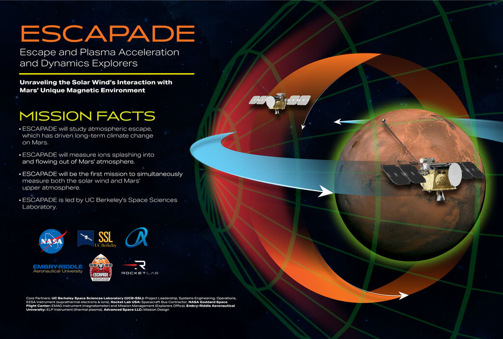


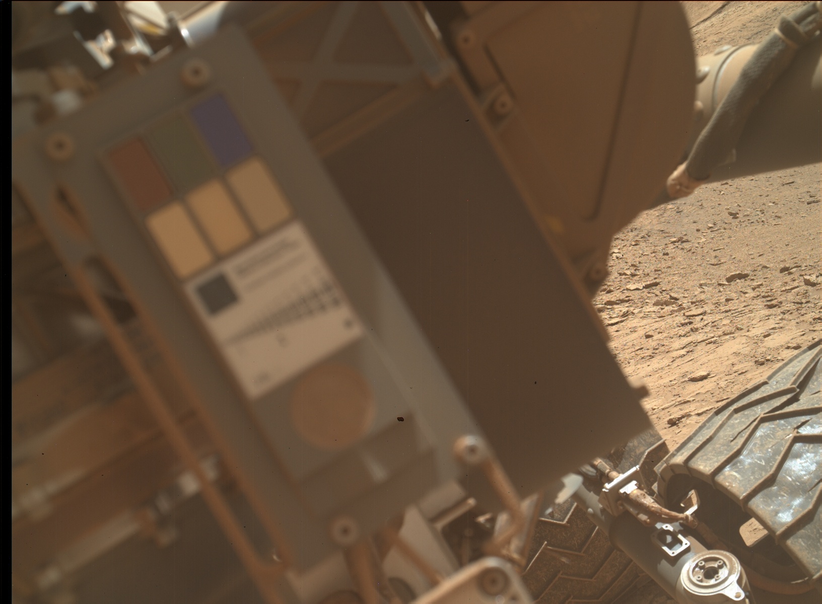


 I need to highlight these ==very important words==.
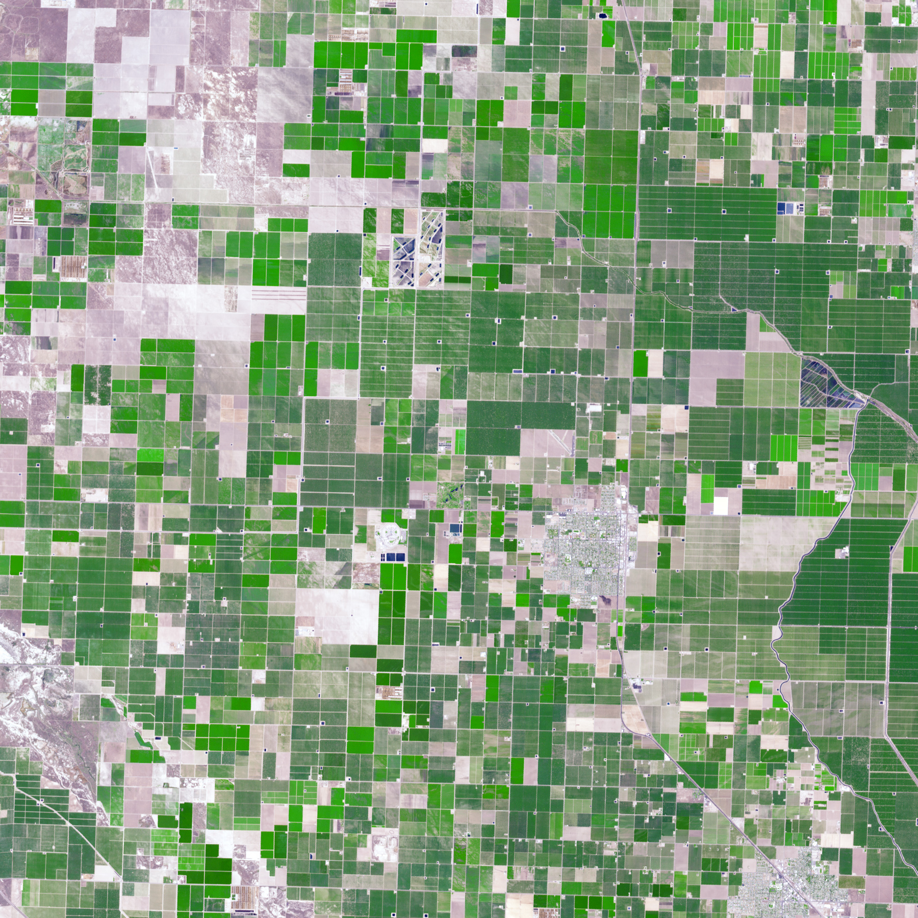
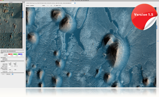


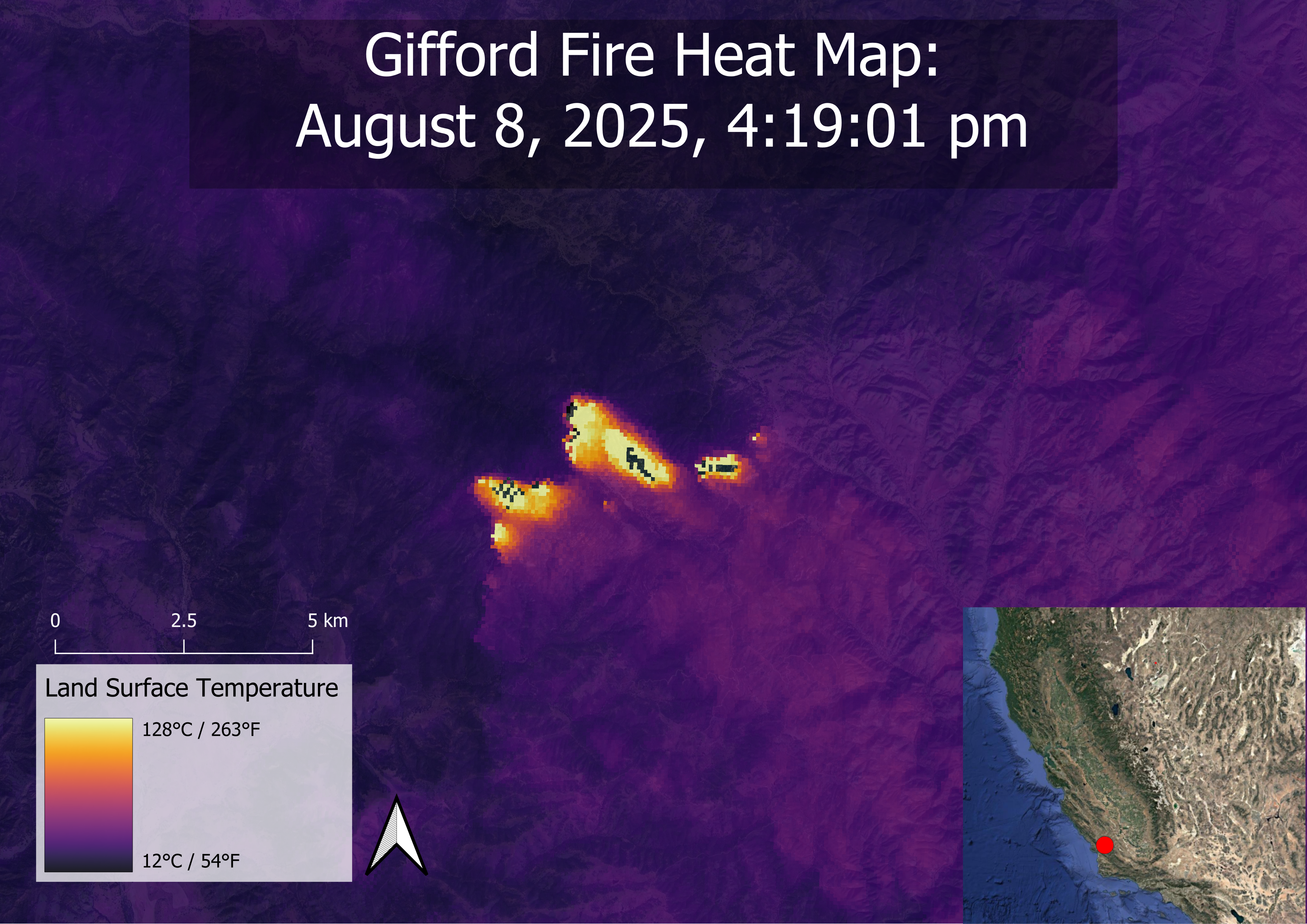

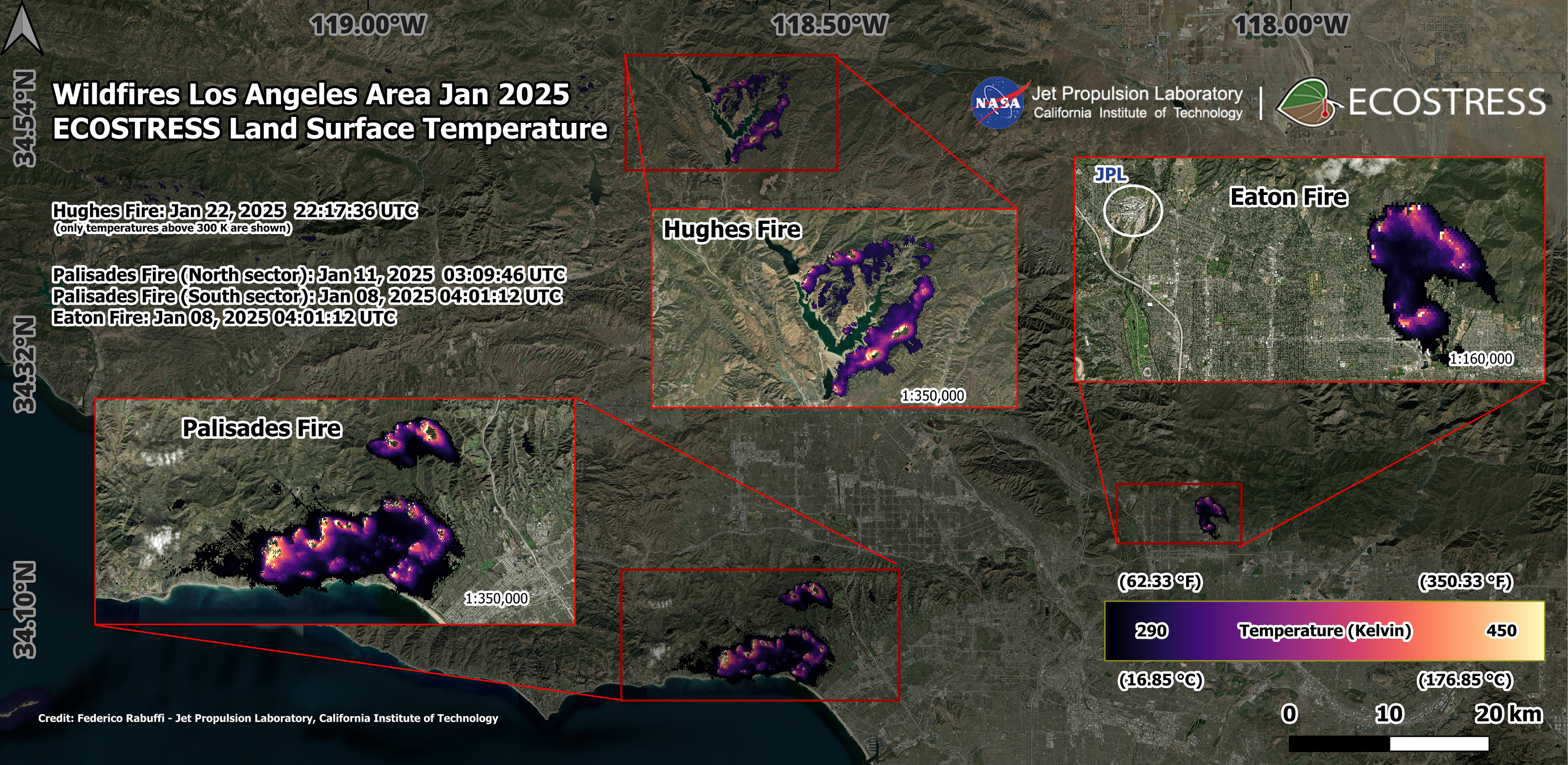 @nasa-pds @nasa-jpl @nasa @whitehouse

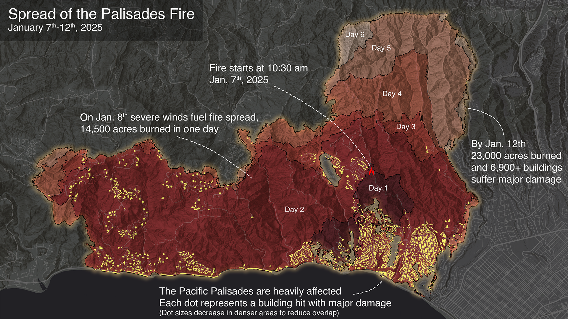
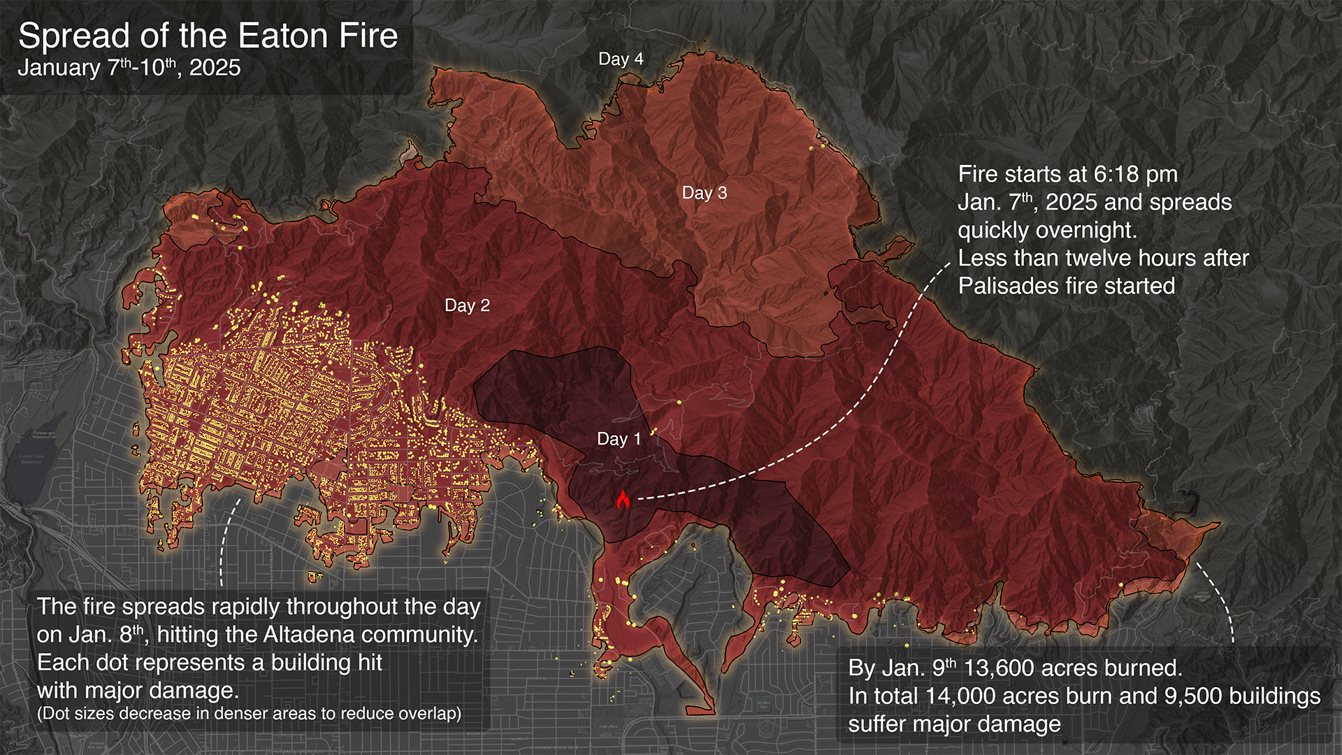
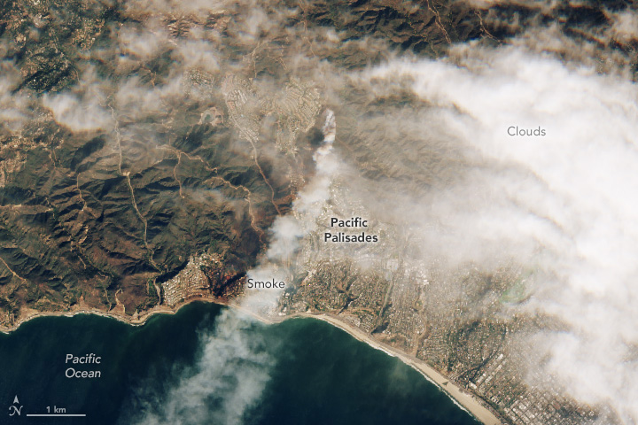


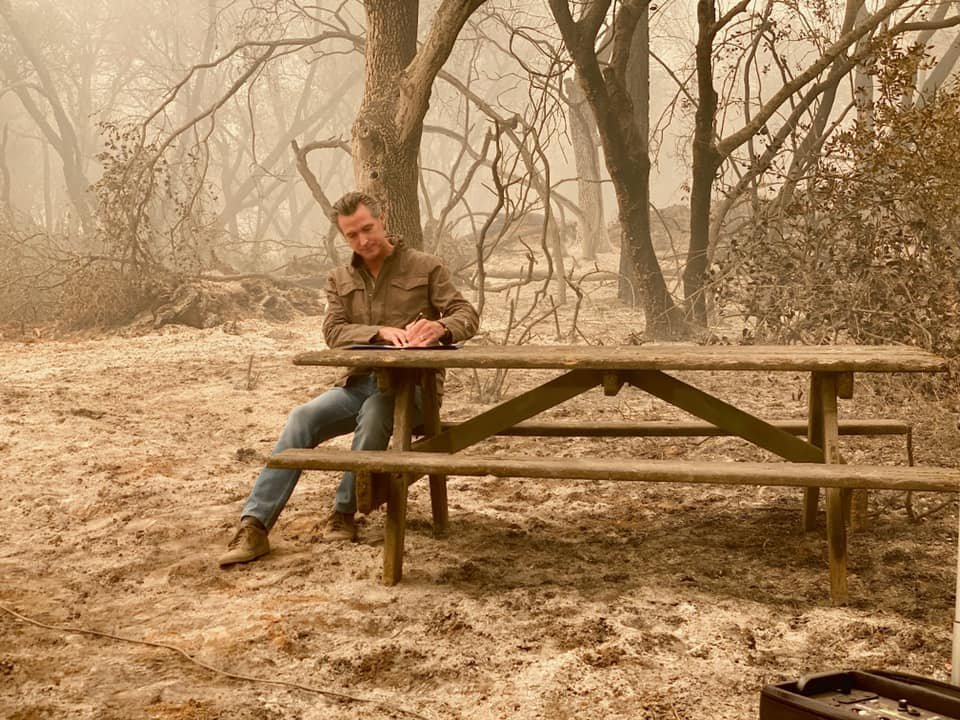 California Gov Gavin Newsom has asked Congress to approve nearly $40 bn in aid to help LA recover from Jan’s devastating wildfires. Estimates of the Total economic loss from firestorm have been estimated to surpass $250 bn
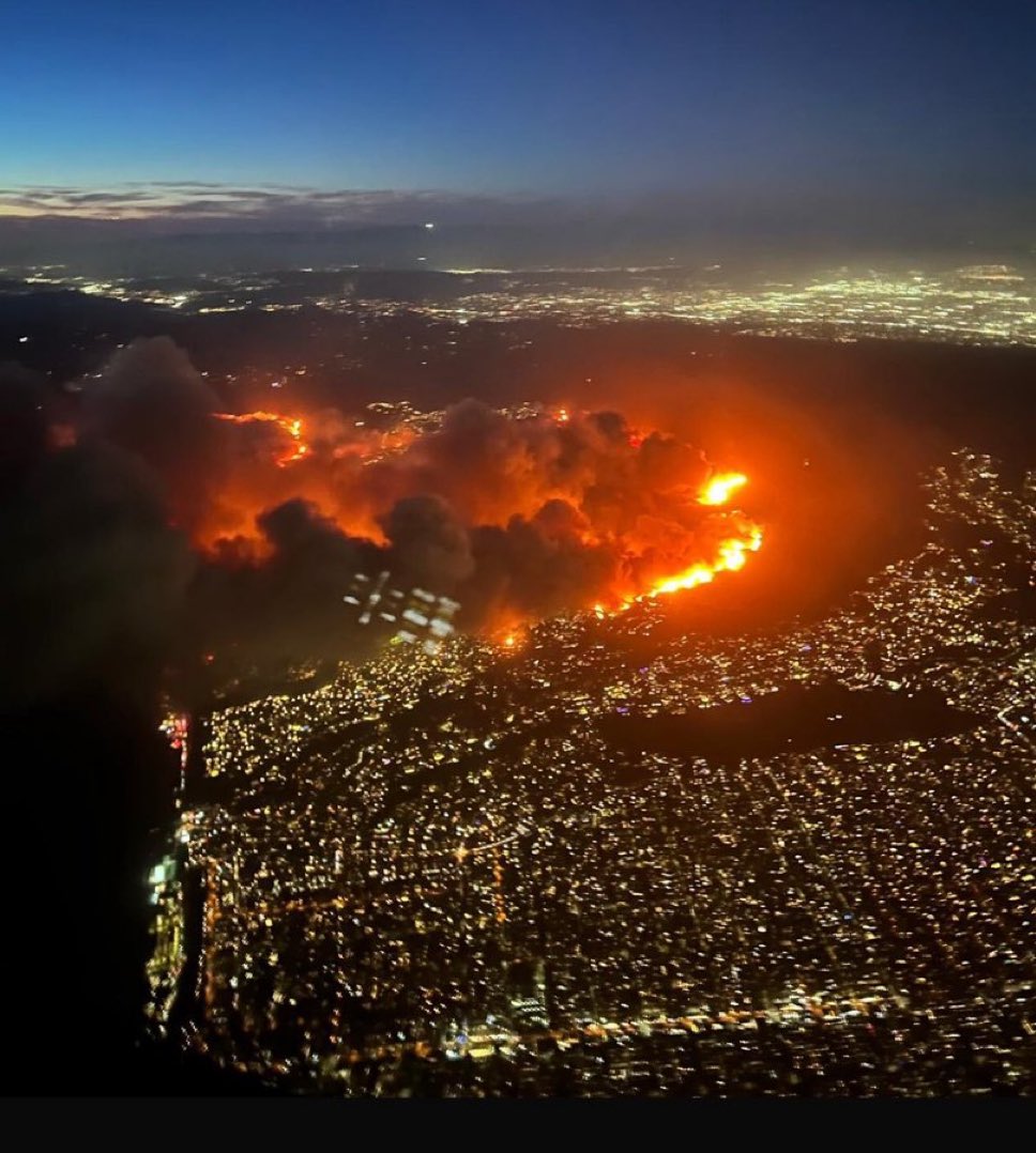


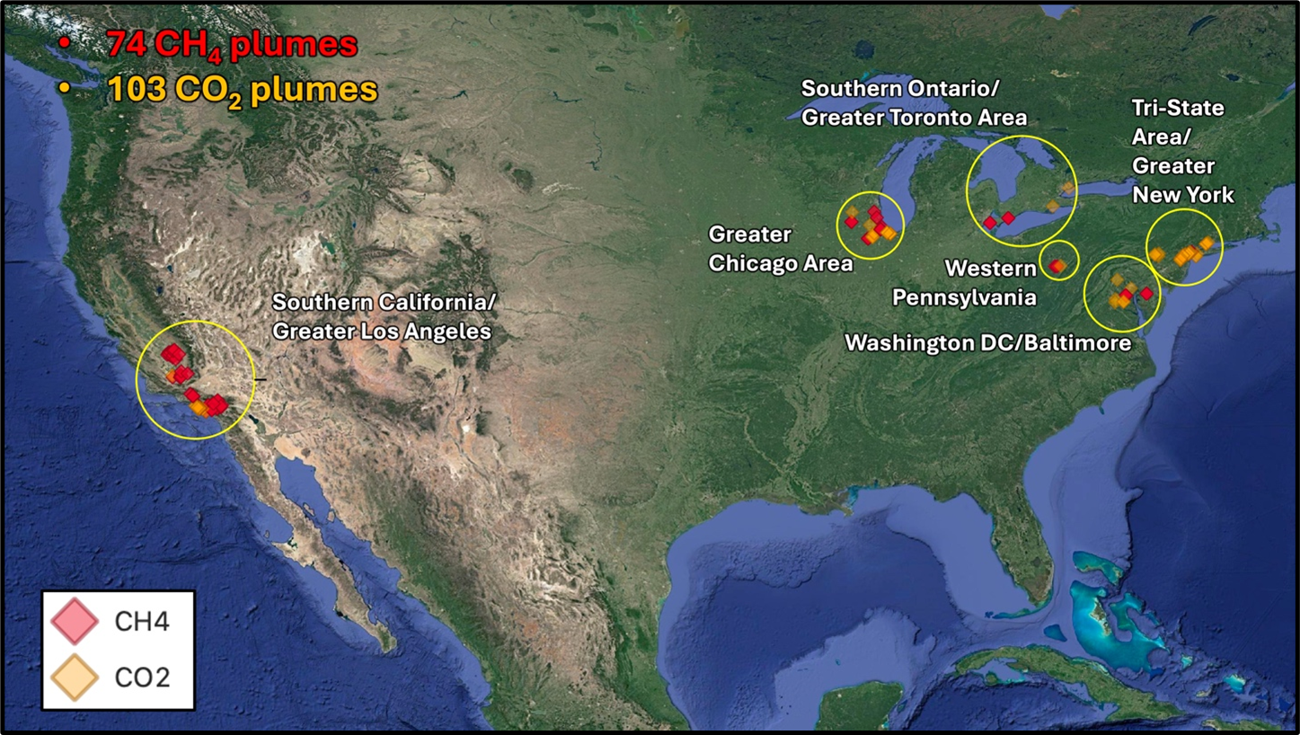 Jensen, D.J., H. Bender, and A.K. Thorpe. 2025. STAQS AVIRIS-NG-derived Methane and Carbon Dioxide Plumes, 2023. ORNL DAAC, Oak Ridge, Tennessee, USA. https://doi.org/10.3334/ORNLDAAC/2406
 Hi im
Hi im 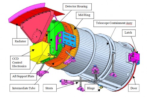 EPIC (Earth Polychromatic Imaging Camera) is a 10-channel spectroradiometer (317 – 780 nm) onboard NOAA’s DSCOVR (Deep Space Climate Observatory) spacecraft. EPIC provides 10 narrow band spectral images of the entire sunlit face of Earth using a 2048x2048 pixel CCD (Charge Coupled Device) detector coupled to a 30-cm aperture Cassegrain telescope
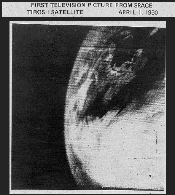


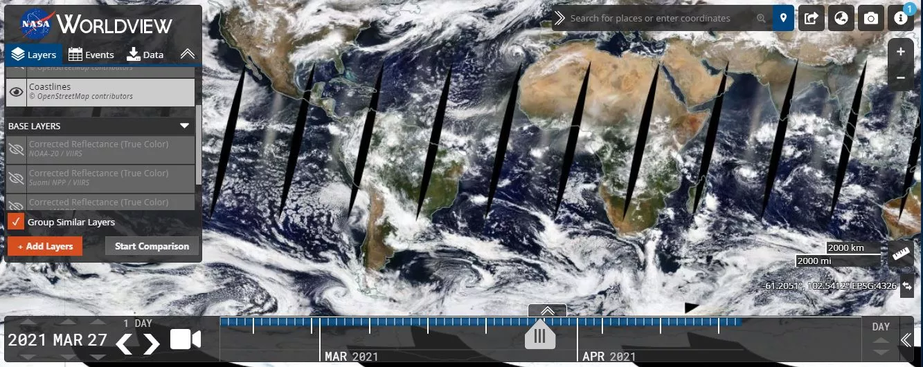
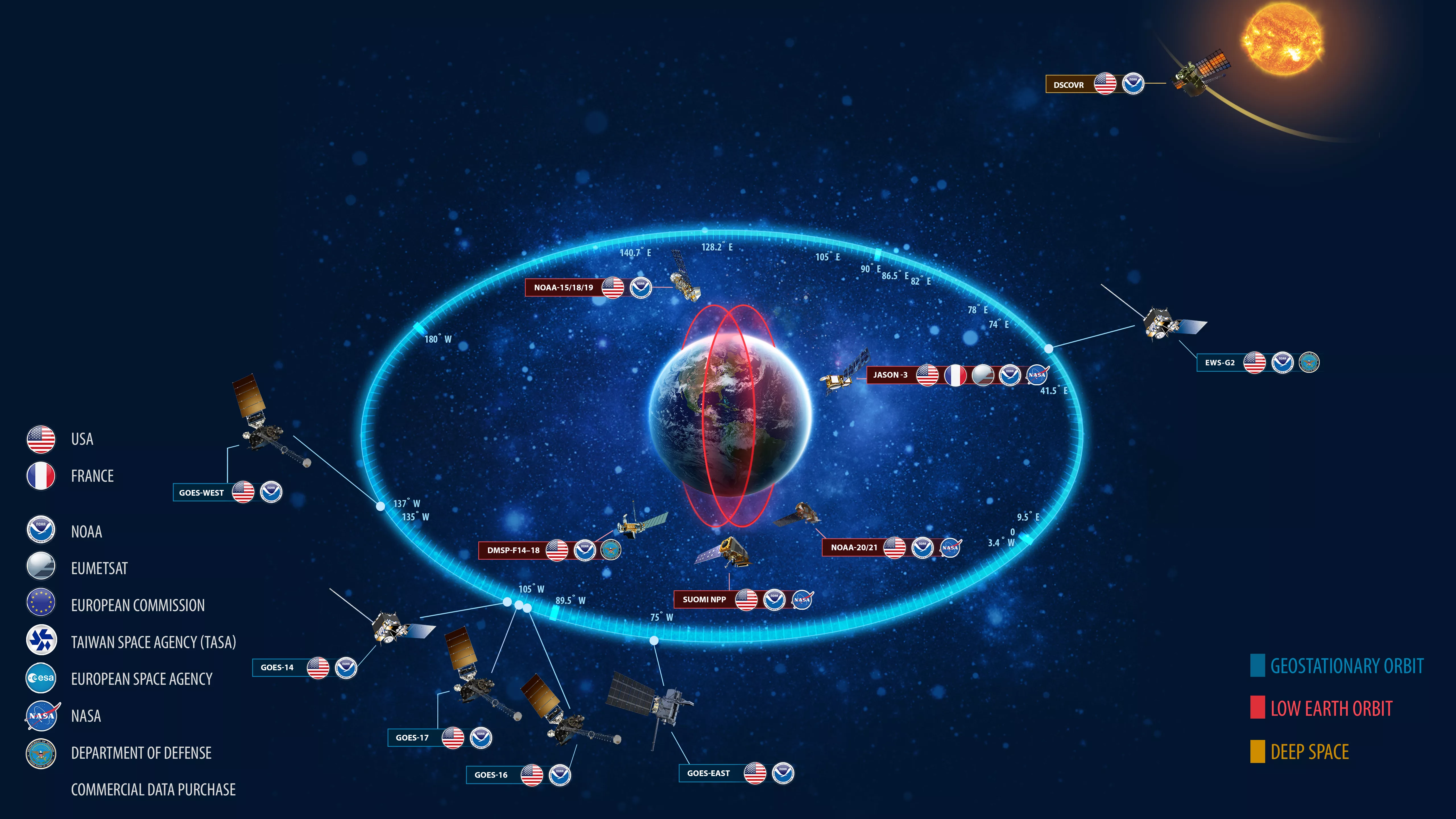
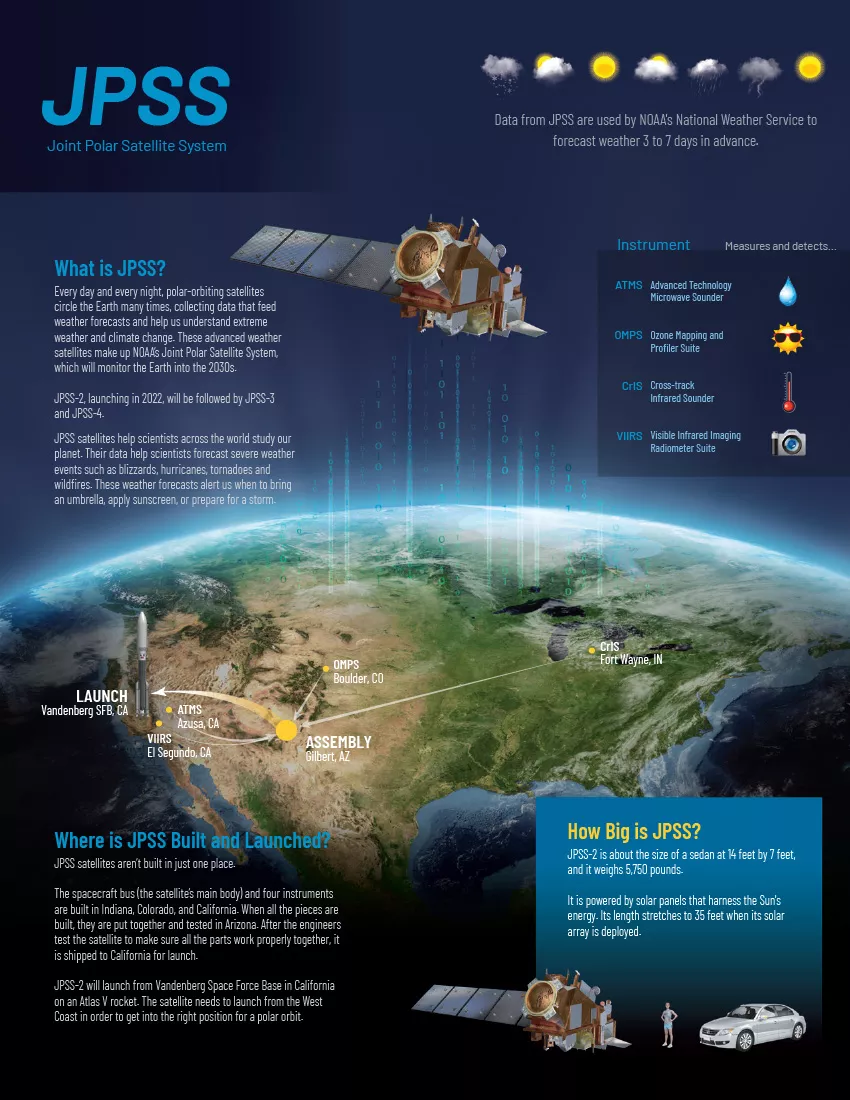

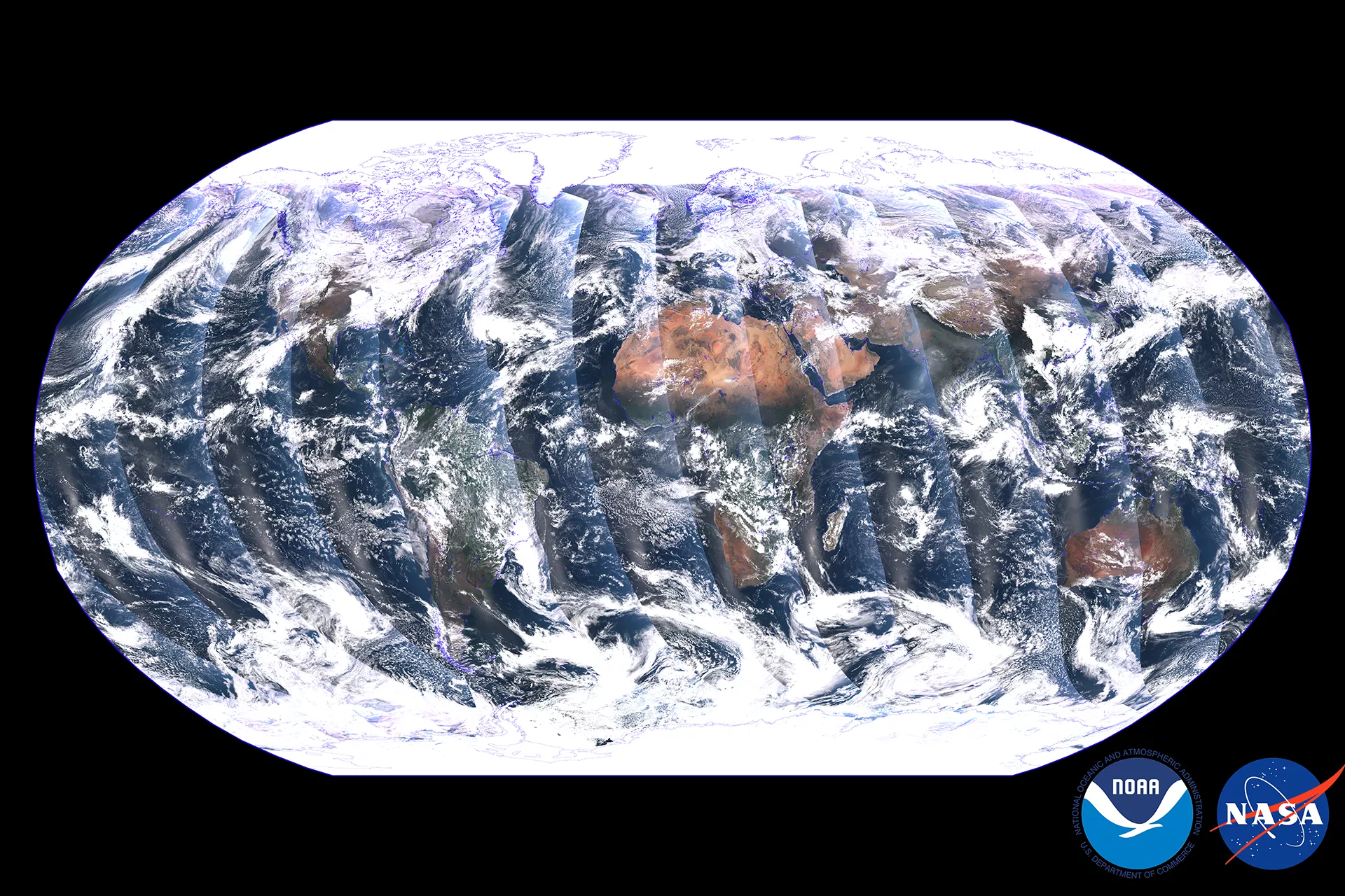
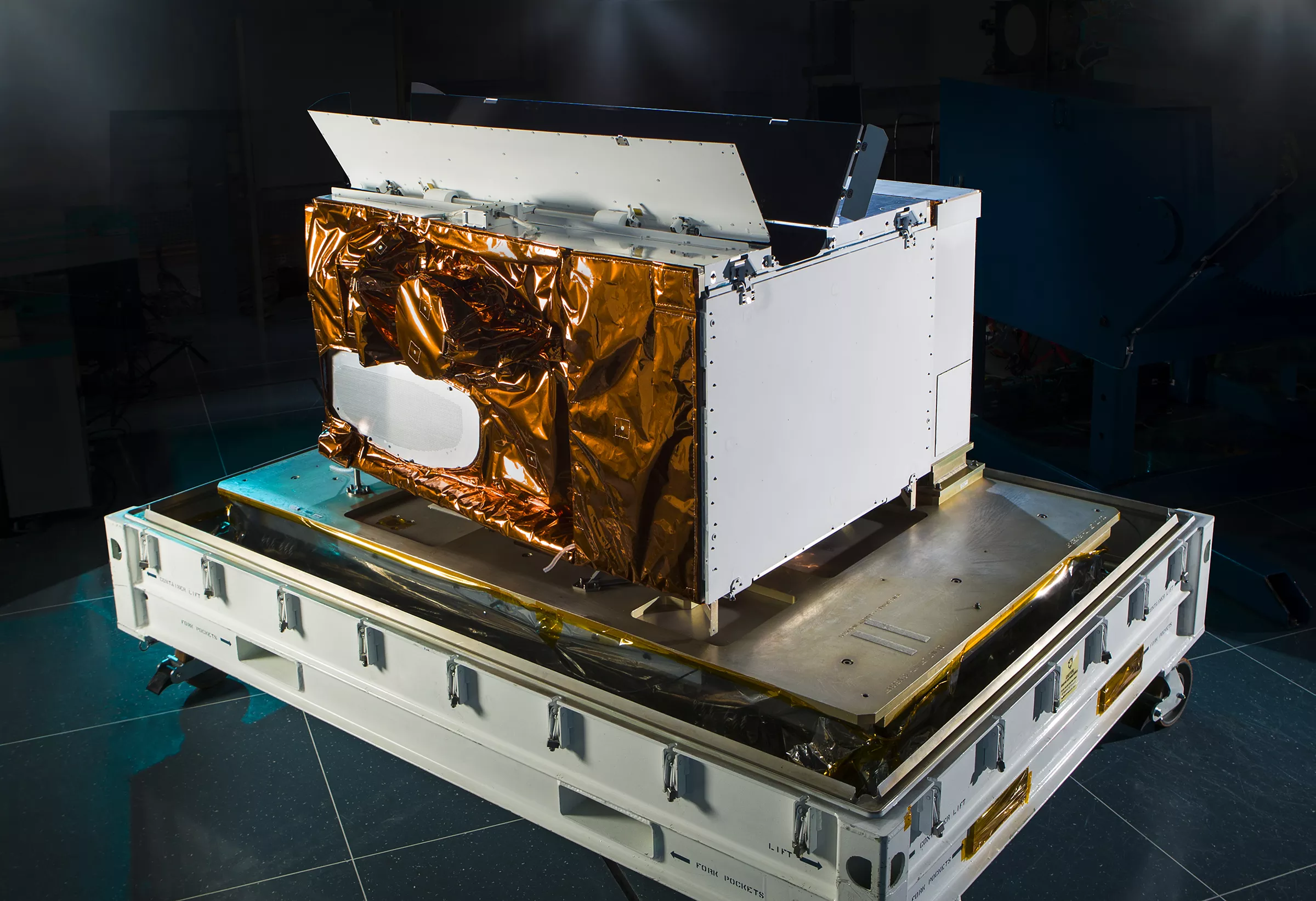
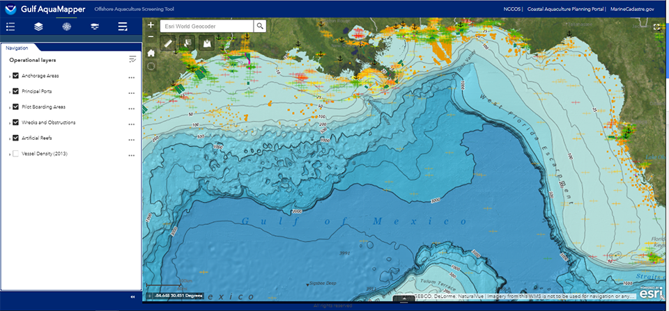


 All of the NASA/JPL-generated SPICE data and allied software are freely available to all U.S. citizens whose tax dollars make the operation of NASA missions and the NAIF activity possible.
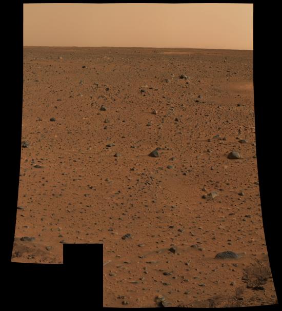
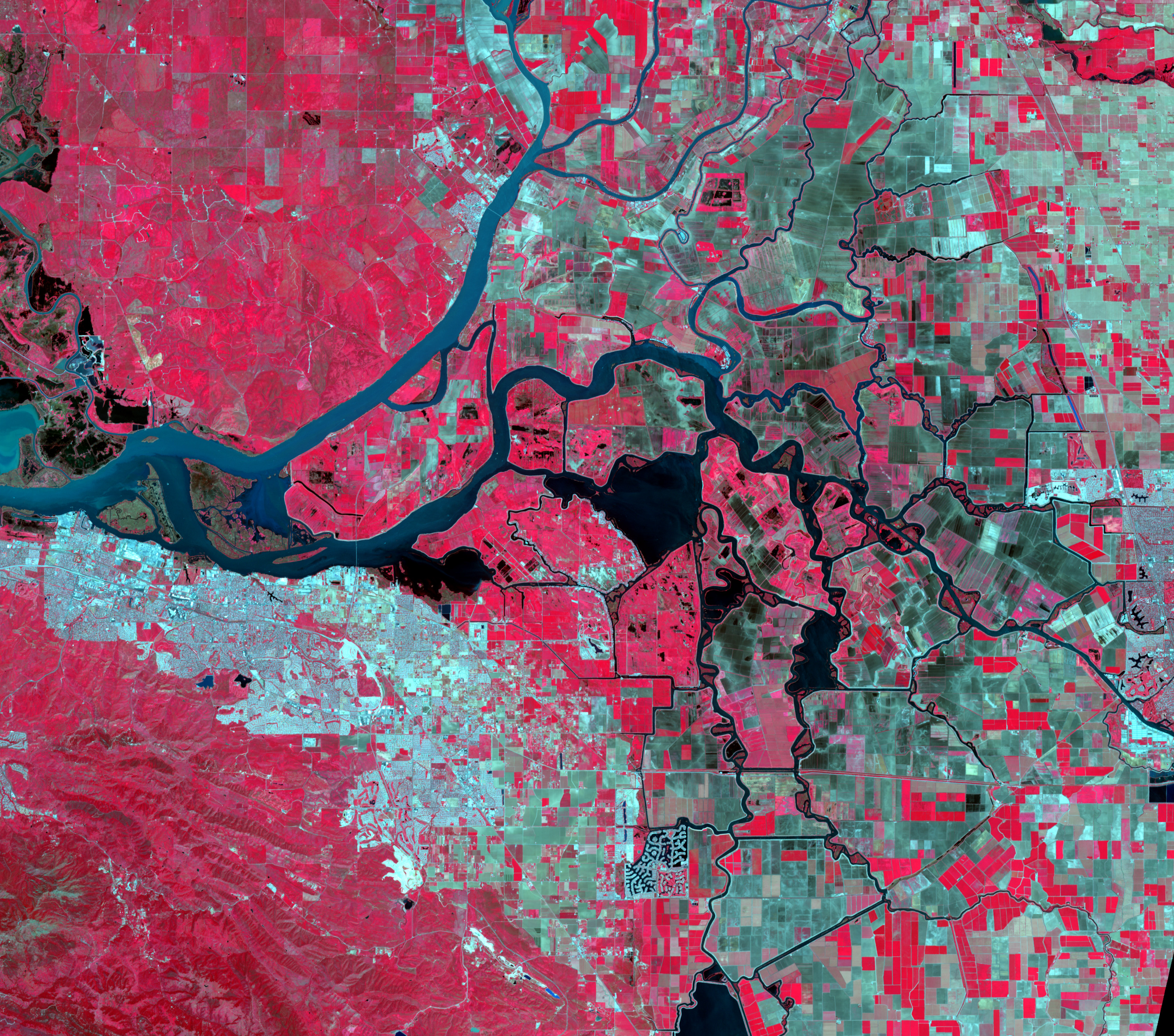