NOAA/NASA[JPL]
Written on April 18, 2025 April 18th, 2025 by
by
tags: 18 April 2025CLimateTunes
The Dramatics - In The Rain Handsome Boy Modeling School - Waterworld Parliament - Motor Booty Affair - Full Album Aqua Boogie (A Psychoalphadiscobetabioaquadoloop)
DOD INSTRUCTION 8510.01 RISK MANAGEMENT FRAMEWORK FOR DOD SYSTEMS : Effective: July 19, 2022 @nasa @whitehouse @deptofdefense
# California_LiNUX:#La_River+ BashScript
Del ALmo Canal ; ComptonCreek : Wiki
Compton Creek is a major tributary of the Los Angeles River in and surrounding Compton in Los Angeles County, California. Its Loaded with biomass, gonna start my plots @podaac @nasa-jpl @darpa @noaa station [area Chlorophyll :: [STREAM - ladsweb.modaps.eosdis. @nasa.gov] Monitor water quality with high-resolution satellite imagery to support timely decision-making(https://ladsweb.modaps.eosdis.nasa.gov/stream/) Compton Creek Natural Park at George Washington Elementary Compton Creek Walking Path Phase I
California_Linux:GIOVANNI->Findhub? HotpepperSauce
LDOPE @nasa-jpl KOLA 99.9 is a commercial FM radio station licensed to Redlands, California, and airs a classic hits radio format.
Video @nasa of my activity during the jun7 iss flyover los angeles
California_Linux:GIOVANNI->Findhub? HotpepperSauce
@NorthropGrumman
STPSat-6
Advanced Spacecraft for the USSF, NNSA, and NASA WhitePaper : WiKi : check the comments on this post SpaceCommand USAF Space and Missile Systems Center class KirtLand.af [Space Test Program (STP) Management and Funding(https://dod-executiveagent.osd.mil/Agents/ViewAgent.aspx?agentId=56) RAiden_DX
Heavy Metal - 1981
@usgs @nasa-jpl @podaac
The WaterDashBoard is back up
@nasa-jpl @nasa @atfweb @dhs-gov @cityoflosangeles @ucla @stateofcalifornia Mayor KAren, Our cameras in Losangeles are broken, still, play with the map ! I included goodies the team added in like water temp etc… its your drought report for Mr NEwsom @CAWaterBoardDataCenter, DroughtMon is another tool, im working on Aviris and will come back later @whitehouse @nasa @nasa-jpl
Monitoring California Groundwater
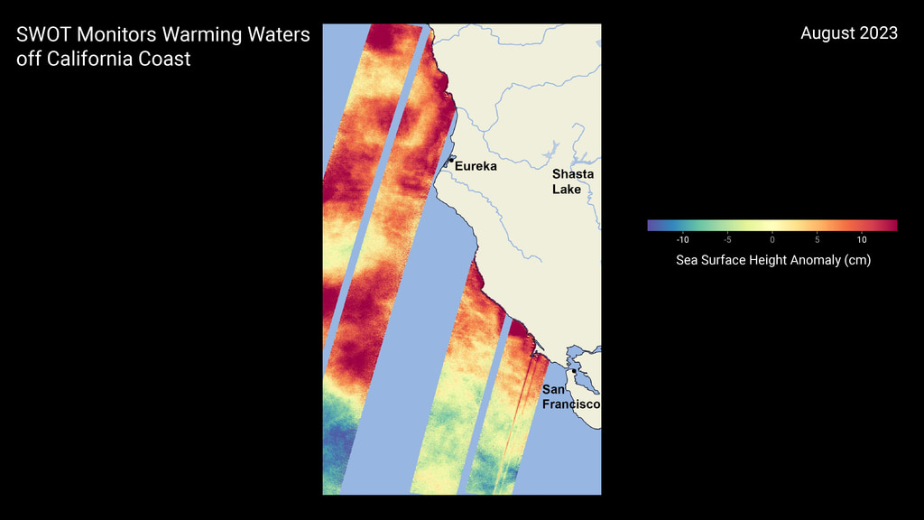
SWOT Monitors Warming Waters Off California Coast
Full Resolution
Daytona USA (Revision A)
on iframes i may have to add a poster attribute manually like with the <video> tag
<iframe src="https://www.retrogames.cc/embed/43757-daytona-usa-revision-a.html" width="600" height="450" frameborder="no" allowfullscreen="true" webkitallowfullscreen="true" mozallowfullscreen="true" scrolling="no"></iframe>
KOLA 99.9 is a commercial FM radio station licensed to Redlands, California, and airs a classic hits radio format.
Street Fighter II’ - Hyper Fighting (Street Fighter 2’ T 921209 USA)
STAQS AVIRIS-NG-derived Methane and Carbon Dioxide Plumes, 2023
This dataset contains enhanced column-integrated methane (CH4) and carbon dioxide (CO2) (concentration lengths) acquired from 211 flight lines across North America imaged by the Airborne Visible/Infrared Imaging Spectrometer-Next Generation (AVIRIS-NG) between June 26 and August 15, 2023 for NASA’s Synergistic TEMPO Air Quality Science (STAQS) campaign Documentation Revision Date: 2025-06-20
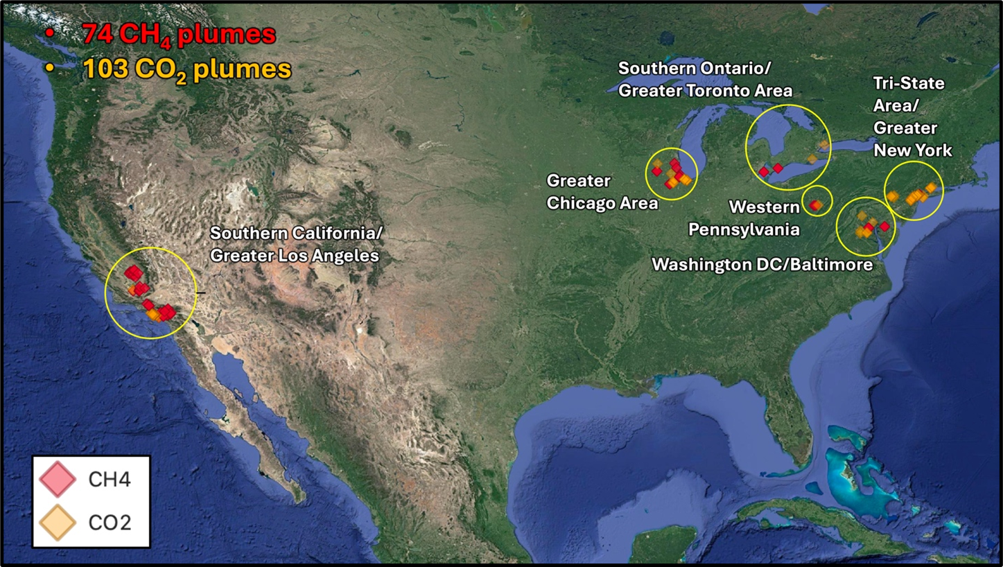 Jensen, D.J., H. Bender, and A.K. Thorpe. 2025. STAQS AVIRIS-NG-derived Methane and Carbon Dioxide Plumes, 2023. ORNL DAAC, Oak Ridge, Tennessee, USA. https://doi.org/10.3334/ORNLDAAC/2406
Likeable ?
Eric Garcetti's voice
Garcetti’s opening statement at his confirmation hearing to be United States ambassador to India
Recorded December 14, 2021
Los Angeles - What It’s Really Like Now 🇺🇸
@usgs The WAterDashboard has had bad connectivity in Los Angeles County @Noaa @nasa-jpl @podaac - Rashard
The first issue i had, I was riding The Dash to Griffith, an i went to the water dashboard an the router went down
FiRMS Egypt’s Mediterranean Coast
[TLDr;]
i read the @cityoflosangeles @stateofcalifornia Mammal NeuroToxinAlert and wanted to share some data, but got long winded… I will organize my notes and report regularly data i get from pace - rashard_mars_recon_orbiter
DearSupervisorLindsey
 Hi im Rashard, I work at Nasa/JPL @nasa-jpl @nasa @whitehouse, I came across a short bulliten in SantaMonicaDailyPress about an issue we have locally with sick animals on the beach in the communityNews section. I found an article from lastmonth but this was in this mornings paper
RASHARd @nasa-jpl COViDBRAiNDUMP
newspapers - PDF
![]() RashardOnTrello
RashardOnTrello
SUPERVISOR LINDSEY P. HORVATH
Re:Natural toxin killing SoCal sea mammals
ARTiCLE Dolphins and sea lions that have died along the Southern California coast in recent weeks may be victims of a deadly neurotoxin produced by a seasonal algae bloom, experts said Tuesday. ReadMore Sick Animal Notes
Sea surface salinity datasets are now accessible -SOURCE @nasa
COViDBRAiNDUMP-Rashard_iMAN_Kelly @nasa-jpl @nasa @cdcgov
https://t.co/DlL6Lzlyyk #BioMAss @NASAEarthData @GeorgieC @Zoeapie we got a lot of sick animals is someone poisoning #TheKelp @ucla https://t.co/G6Lqs1Ik8b @sustainUCLA @UCLAIoES) / X -#Rashard @NASAMars @NASAInSight @NASAPersevere #Mars2020 #gm @BlackGirlsCode
— BubbleGumPop (@BubbleGumPop510) May 12, 2025
@MayorOfLA https://t.co/7pWrwI5Y2W @smdailypress + https://t.co/YYm70GEjmc @NASAGoddard #Gm @VeronicaMcG `Natural toxin killing SoCal sea mammals`
— BubbleGumPop (@BubbleGumPop510) May 12, 2025
im trying to find some plots to see water content. im loggedin #MsPetro iHave been beening erased from the web @essence-#sinfulLust
![]()

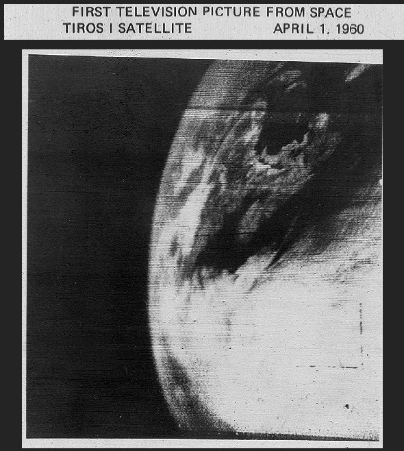
DSCOVR: EPIC
DSCOVR: Deep Space Climate Observatory
![]()
📻Handsome Boy Modeling School - Waterworld📻 DSCOVR: Deep Space Climate Observatory The Deep Space Climate Observatory, or DSCOVR, was launched in February of 2015, and maintains the nation’s real-time solar wind monitoring capabilities, which are critical to the accuracy and lead time of NOAA’s space weather alerts and forecasts… It sits Behind the moon from my understadning and that position is how it is able to capture LunaRoccultation so well
What is an occultation in astronomy?
A lunar occultation in astronomy is when the Moon appears to move in front of another object in the sky like a star, a planet or an asteroid. - @AntonVamplew Anton Vamplew - BBC
WHAT IS EPIC?
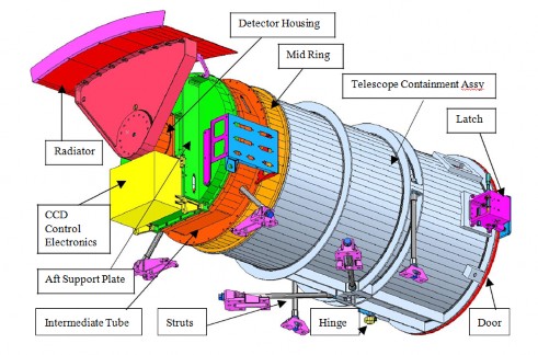 EPIC (Earth Polychromatic Imaging Camera) is a 10-channel spectroradiometer (317 – 780 nm) onboard NOAA’s DSCOVR (Deep Space Climate Observatory) spacecraft. EPIC provides 10 narrow band spectral images of the entire sunlit face of Earth using a 2048x2048 pixel CCD (Charge Coupled Device) detector coupled to a 30-cm aperture Cassegrain telescope ReadMore
50 Years of GOES
In 2025, NOAA celebrates 50 years of its heralded Geostationary Operational Environmental Satellite program, known as GOES. For five decades, NOAA and NASA have partnered to advance NOAA satellite observations from geostationary orbit.
Interactive Global Geostationary Weather Satellite Images
George C. Marshall Space Flight Center GOES satellite image map to view data -
CLiCKHEREThe SPoRT Viewer is an interactive tool that displays dynamic imagery from various Earth Science resources map
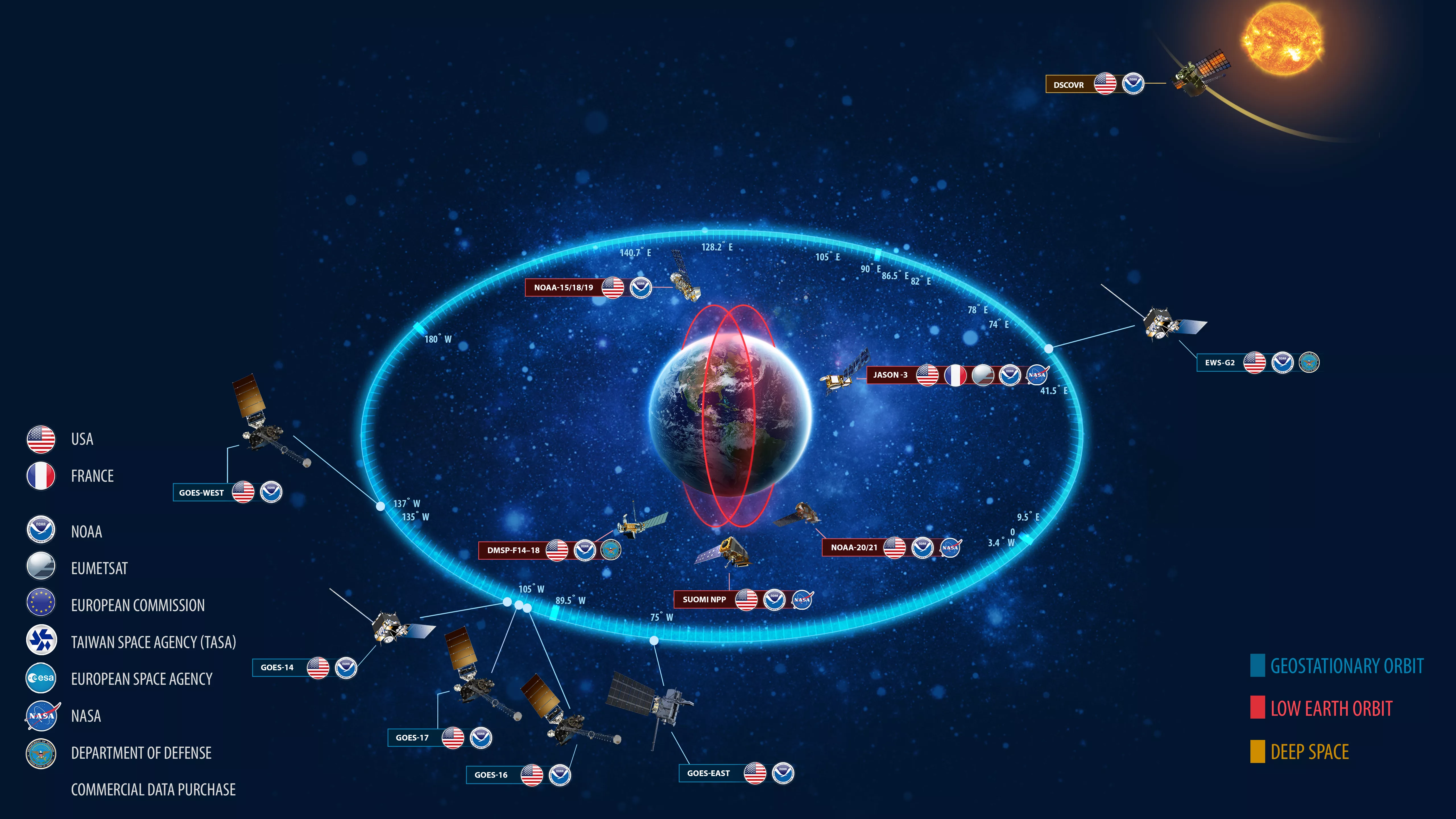
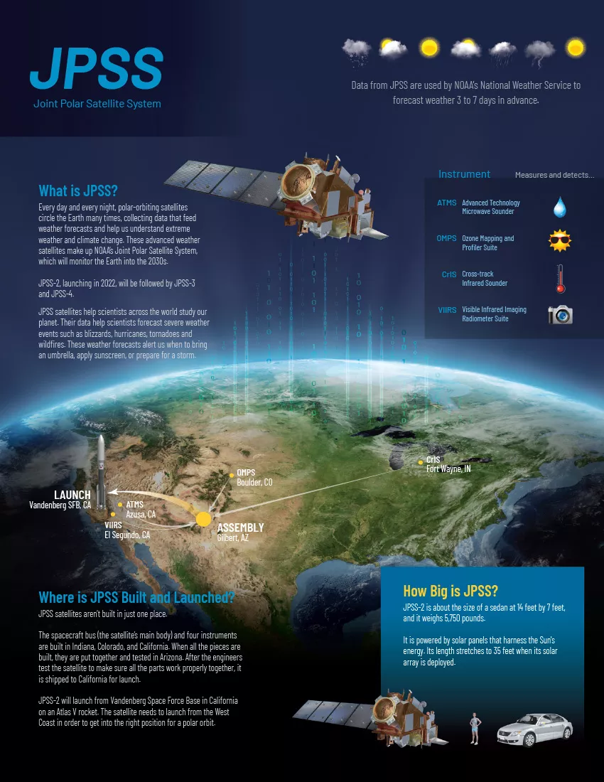
NOAA-21, NOAA-20, and Suomi NPP orbits
NOAA’s Joint Polar Satellite System (JPSS) provides global observations that serve as the backbone of both short- and long-term forecasts, including those that help us predict and prepare for severe weather events. The five satellites scheduled in the fleet are the currently-flying NOAA/NASA Suomi National Polar-orbiting Partnership (Suomi NPP) satellite, NOAA-20, previously known as JPSS-1, NOAA-21, previously known as JPSS-2, and the upcoming JPSS-3 and JPSS-4 satellites. The Mission - JPSS History of NOAA Satellites @noaa
NOAA Works with NASA JPL to Explore Mitigation of Data Corrupting Radio Frequency Emissions Joint Venture Partnerships The Joint Venture Partnerships allows NESDIS to prioritize engagement with the private sector, academia, and other federal agencies. NEDiS NASA Awards Delivery Order for NOAA’s Space Weather Program
NOAA workers report ‘intentional chaos’ during personnel cuts
Some of the former government employees who were fired, rehired and fired again said they’re owed pay and their health plans have been frozen; Some workers at the National Oceanic and Atmospheric Administration who were fired in February, rehired in March and then fired for a second time in April, say the agency has missed some salary payments during that period, and failed to have their health insurance plans restored or provide basic paperwork…ReadMore Evav Bush @nbcnews 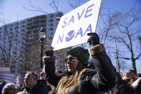
 Related
°Goes Wind calculator Interactive Global Geostationary Weather Satellite Images - GOES ALERTCalifornia is a UC San Diego Program OPEN TOPOGRAPHY Acme Mapper
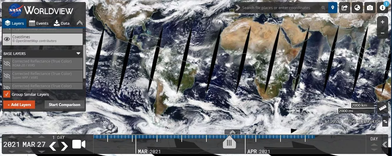
NOAA Latest Satellite Imagery This tool comes from our partners at NASA, and allows us to interactively browse global, full-resolution satellite imagery via their Earth Observing System Data and Information System ( EOSDIS ). - @noaa This Earth Day, Explore Our Amazing World from Above
Currently Flying
The Earth Observer
The Earth Observer newsletter, published by NASA’s Science Support Office (Code 610) at the Goddard Space Flight Center, has been an authoritative source for consolidating NASA Earth Science news for over three decades. Past issues are available for download via the ARCHiVE
Air Quality

White House Plan Calls for NOAA Research Programs to Be Dismantled
A Trump administration budget proposal would essentially eliminate one of the world’s foremost Earth sciences research operations. NTYiMES
Weather & climate office hour 04/14/2025: Dismantling of NOAA, NASA, & climate research accelerates
The latest in a recurring series of live, virtual, & interactive “office hours” hosted by Dr. Daniel Swain on various topics related to extreme weather and climate. 04/14/2025 topic: Breaking news in recent days surrounding even deeper and more startling cuts to NOAA, NASA, FEMA, and other federal entities responsible for predicting, responding to, or studying weather, climate, wildfires, and disasters in the United States have been raising growing alarm. I’ll discuss the latest in today’s session, with a focus on potential short and long-term consequences of this proposed and/or unfolding large-scale dismantling of American science. WATCH channel:Weather west
![]()
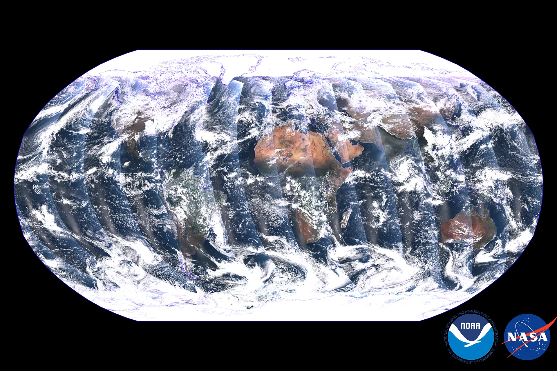
First Image Released from NOAA-21 VIIRS instrument
December 8, 2022
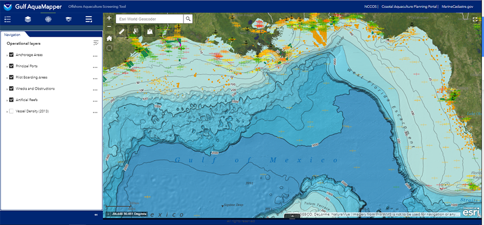
 New Tool Available for Aquaculture Siting in Gulf of Mexico
NOAA Satellites Help Show Historic Flooding Along Ohio River
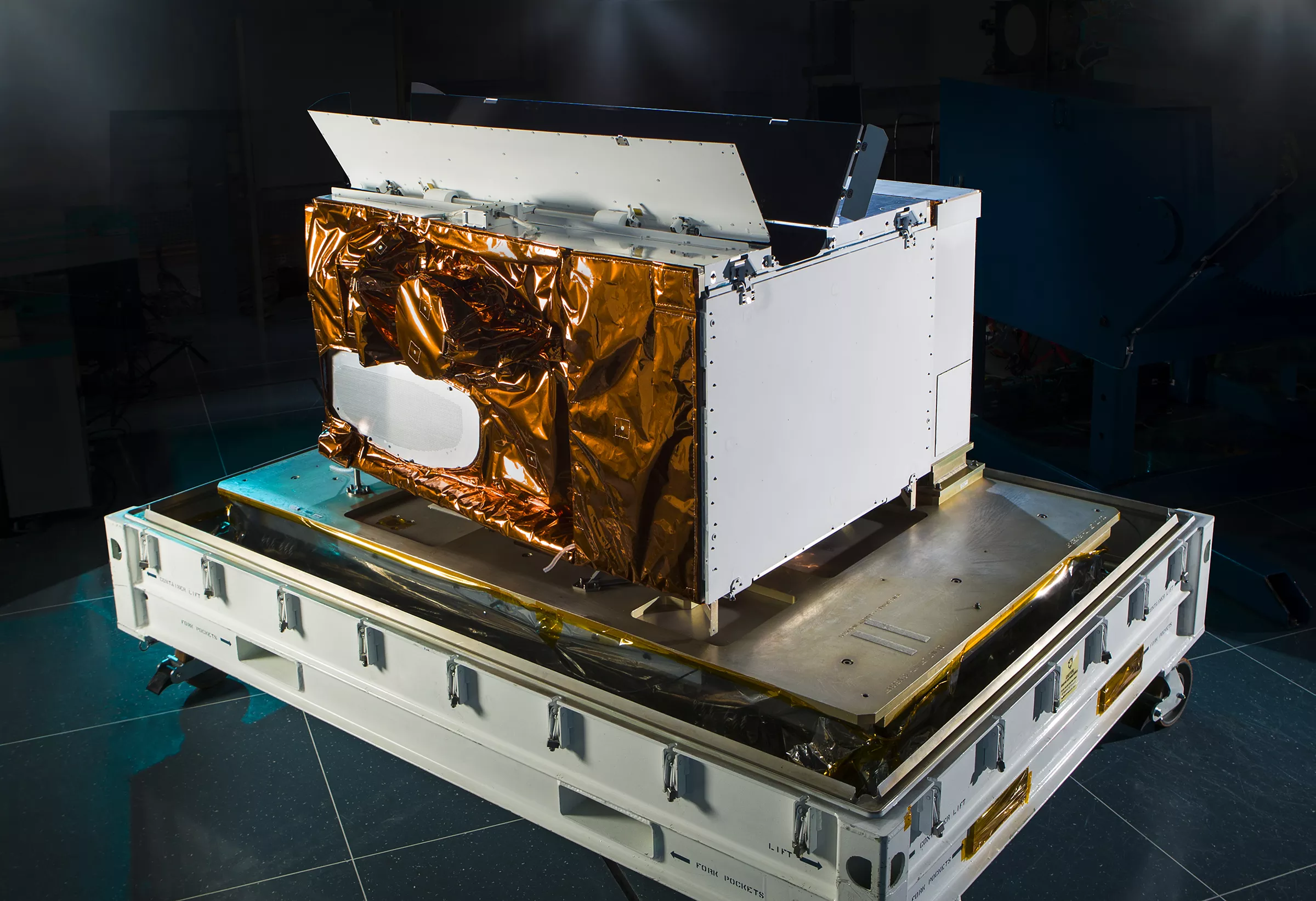
ViiRS…
Is an Instrument like ECOSTRESS
The Visible Infrared Imaging Radiometer Suite (VIIRS) instrument collects visible and infrared images and global observations of the land, atmosphere, cryosphere and oceans.
50 Years of GOES @noaa
In 2025, NOAA celebrates 50 years of its heralded Geostationary Operational Environmental Satellite program, known as GOES. For five decades, NOAA and NASA have partnered to advance NOAA satellite observations from geostationary orbit. GOES are our sentinels in the sky: keeping constant watch for severe weather and environmental hazards on Earth and dangerous space weather. - @nasa GOES East and GOES West Coverage of Western Hemisphere @noaa on YOUTUBE 
VIDEO: LUNAR TRANSIT 2015: 2015
GALLERY: WEST COAST WILDFIRES
 VIDEO: LUNAR OCCULTATION 2015: 2015
Rashard on TRELLO Limits for free account - John Agius May 2021 SPACE_WEATHER.PDF
![]() wiki:Talk
wiki:Talk
its always low cost bc yall scared to openly work on pornography … Councilmember Marqueece Harris-Dawson without getting in ppl pants Congressmember Karen Bass
@cityoflosangeles CD8 :: CD8 EMAiL @nasa-jpl @nasa @atfweb @dhs-gov https://cd8.lacity.gov/connect/contact ARTiCLE:LiZCOOPER-Where to Get Affordable Internet in Los Angeles - human-i-t.org

i remember you from bull st… Veronica McGregor she rememberes when i first started painting walls and basic’d the 12ozProphet greats for me she was like Kash Doll but that was not obvious im talking #Manessa Georgia Division of Family & Children Services like a person who knew a lot of p[eople in many different worlld an was teaching at SCAD Office - German University in Cairo #savanna WTOC-TV Tats Cru she know you guys well and If i remember correctly she was the grounding point that helped me not get hurt feelings by #WhiteBoyProstitutionGraff! and i k3ept making art Kimberly Bryant, Founder Black Girls CODE Congressmember Karen Bass NASA Earthdata Veronica McGregor NASA Space Communications and Navigation . . . #Thanks_MsMitchell i need help with some girls that grew fond of me in atlanta… I dont know what to do, polygamy is legal, but only with hustler hollywood ties in this area Los Angeles County Sheriff’s Department Councilmember Marqueece Harris-Dawson MyRepost OP
@nasa-jpl @nasa #Kennedy The Free Agents (FA) Crew was Established in 1985
Dekae FA, Inkheads - Miami, March 2023
He started writing in Miami, 1983. We chat about his personal history, his traveling and photo trading in the days before the internet and his mixed feelings and responsibility around being part of the early wave of graffiti on the internet as part of the crew that borough us 12ozProphet.com
CALiFORNiA_LiNUX:My Git Hub Journey To The Web Interface RASHARD IMAN KELLY NASA M R O I S S ECOSTRESS SWOT
@stateofcalifornia @nasa @whitehouse @nasa-jpl @cityoflosangeles
Aqua Boogie (A Psychoalphadiscobetabioaquadoloop)
@nasa-jpl @youtube embeds dont have PersistentLinks … ThierUse@stanford
src="https://www.youtube.com/embed/g3UC1KpSYLE?list=RDg3UC1KpSYLE" top
src="https://www.youtube.com/embed/g3UC1KpSYLE?si=dl2vei9HLzuJOmbn" bottom
layout: default title: HoleToAnotherUniVersE