Worklog
Written on March 22, 2025 March 22nd , 2025 by
by
tags: 22 March 2025
|
|||||||||||||
|
Computer Hacking Documentries Mega Collection - Creation of the Computer (History)
Media query work @nasa-jpl commit 730dfa4586bcfa7a36b7470dbb74f90037606041
@nasa-jpl I have some of the ConcertPosters from TheArtRiot and i wanna drop them off at the gate… @blackgirlscode i dont know her name, but wow, the darkies stole my gut this morning… and we have to figure something out. im still human… @cityoflosangeles MayorKaren
I made MyWorkBlog heaklthier for tables, but its still lokey presentation software so im still tuning the framework . . . - rashard
@soundcloud i hope i can get my account back holetoanotheruniverse40@gmail.com
im blocked cant comment or repost @blackgirlscode im getting sick the ppl that buy you guys in that world are surrounded even if i die… good luck @stateofcalifornia @cityoflosangeles there is an anti joy cult the porno fans formed at the library and they hate me bc i work and live in the area!
We detected unusual activity from your device or network.

Reasons may include:

Rapid taps or clicks
JavaScript disabled or not working
Automated (bot) activity on your network (IP 155.190.2.34)
Use of developer or inspection tools
Need help? Submit feedback.

ID: 35b07e36-adea-c11f-8a25-d7d25abe91d8
@Soundcloud He did a lot of shows and I know Booisie was with a girl i was talking to at some point but Kevin Work an its like a lovely downsouth newcast for ppl in aviation and aerospace that are black and dont steal
@nasa


<~ BACK!
Web Standards

I always took my web development seriously. I was a webmonkey.com reader, i followed lifehacker. Im activly creating trackable work for my role @nasa-jpl. Since The Space Station accesses my data at times i have to be realistic that i dont know the expanse of possibilities i could run into transmitting data. If the browser can accept the connection let it be worth the wait no matter the surface RelatedTweet @nasa-jpl Related - Muna Ahmed Closure? Schema.ORg Checks on /rashardmro Failed checks on DEV=-ricothakarashard.github.io
WorkTweets
Elon vc GoldStone EuropaClipper Research Reccomending The NASA Graphics MAnual to @cityoflosangeles Muna the legend Telling Elon i Work in the DataCenter Remote Local Los Angeles Reads @blackgirlscode this is a workreport for @normani EcoStress Data Share with team @nasa-jpl Dr_PiRat ECOSTRESS instrument info @usgs American Military StripTease Humor - Vintage @nasa-jpl SocialMediaiSSues @blackgirlscode - the job @normani said was mine in bed @nasa-jpl CLPS LUNAR PAYLOAD - meeting attended BLUEGHOST? - Begging their world for cellular help Sonta SecuritySlowDown DownTownCarCrash @cityoflosangeles Trying to find out if SZA is @normani @blackgirlscode Funny Linux Meme about Coral i made Aviris for Fire Ocean Kelp CONNEcTed WATERdashboard HollywoodRsivoir Water Supply Soil Moisture DroughtMon Map of Dams Fire Warnings for Gavin Newsom @nasa-jpl dns forwarding from google earth to firms not working LA_RiVER Contruction Review - old pics I asked Dr_PieRatt to help Ms Bass with River Data A picture for Laurie Leshin identifying MySELF for The Mayor in Los Angeles @cityofLosangeles Formaldyhyde atmosphere Aeronet discovery for monitoring Air Pollution Locally @nasa-jpl Reaching out to @ucla about @nasa-jpl AERONET OCEANDATA @nasa Checking on TekSystems LA_RiVER Live cams Reccomending BigBrother to LAurie and the MAyor Erika in our old mustang Me and Erika Coral getting her hair braided Me in Oakland Me holding Coral Coral at Daycare Matt Lied @nasa-jpl i made some tshirts an dont know what followed The girl with my graffiti on was in my bed! Trying to identify @normani @blackgirlscode Old thaka rashard blog - CSS origins KASHDOLL digital trail @blackgirlscode EuropaClipper Flyby Planning - MArs @nasa-jpl Coral with my Throwie planetBboy Corals Removal Asking Latto if she Erika for help identifying @normani @blackgirlscode BigBrother Architechture Monitoring Tools Data Shared with Arizona Law Enforcement Los Angeles History Wildfire - for Ms Bass Sharing with @esa that they may be a better lead for @MercedesBenz #LunaPAyloads . . . ECOSTRESS update for MArriott Port of Long Beach - Data Contrib . . 1#Phytoplankton off th.. me Complaining about @tmobile at the port Its a hole for criminals! @deptofdefense! WorkDump for @normani to give her options in how she is distributing her role as her role changes in Los Angeles I mislabled an Ecostress post EuropaClipper BlackgirlsCode leadership reccomendations for safety


Astronomy: Mars LandSurveying @whitehouse
i found a crater with a strange texture! and wanted to share it File Location
https://t.co/fzFe0I7Guq https://t.co/czVJUvOpbs #kamaladumpsterfire plz #AskNasa what this is @neiltyson u really in this shit? @nasamars wit a @12ozProphet #acct @BlackGirlsCode @Normani look what I found #yuma 😛🤢🤮 @latto @Essence @TanyaAChristian #HBCU how lazy are u? @usdol pic.twitter.com/9UydqGdmz1
— ricothakarashard (@ricothakarashard) November 14, 2024
Mars Land Surveying : Rocks on Mars
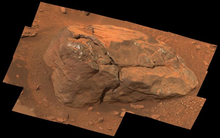
PIA26481: NASA’s Perseverance Observes ‘Observation Rock’
Original Caption Released with Image: This natural-color, high-resolution mosaic showing “Observation Rock” was taken by the Mastcam-Z instrument on NASA’s Perseverance as the rover climbed the western wall of Jezero Crater. The location is near an area the Perseverance science team is calling “Curtis Ridge.”
The 14 frames used to generate the mosaic were acquired on Oct. 18, 2024, the 1,302nd Martian day, or sol, of Perseverance’s mission. NasaPhotoJournal @nasa-jpl
https://t.co/wQuVY8Lq96 #AskNAsa @uarizona @HiRISE @NASAPersevere #What_Color_iS_iT_on_Earth #What_is_True_Color? #StemEducation @ChloeBailey @normani @BlackGirlsCode https://t.co/hdImQ5qBPc https://t.co/mxhY5hYpAi #Mars #astronomy @NASAPersevere https://t.co/0YYt5fve6Q #podCast pic.twitter.com/5JtfPa3dBH
— ricothaka (@ricothaka) November 8, 2024
EarthScience @nasa-jpl
its the faultlines and TheFlintStones I dont know how Los angeles can be irrigated but im scared of the concrete infrastructure and its impact on Southern California @LACountyDPH
https://t.co/ZMC7Wo6pz8 @RepKarenBass I'm in #Hollywood at #iVar_Library @lapublichealth @LAPublicLibrary and I want u tyo look at #TheFaultLines, look like rock quarrys https://t.co/EQfqXsFIBg @blackgirlscode those are #astronaughtPhotos @normani @latto #Tell_Coral @GADFCS pic.twitter.com/hotNLMEZ1X
— ricothaka (@ricothaka) November 14, 2024
Civic / EcoStress @nasa-jpl @nasa EarthScience - Fire
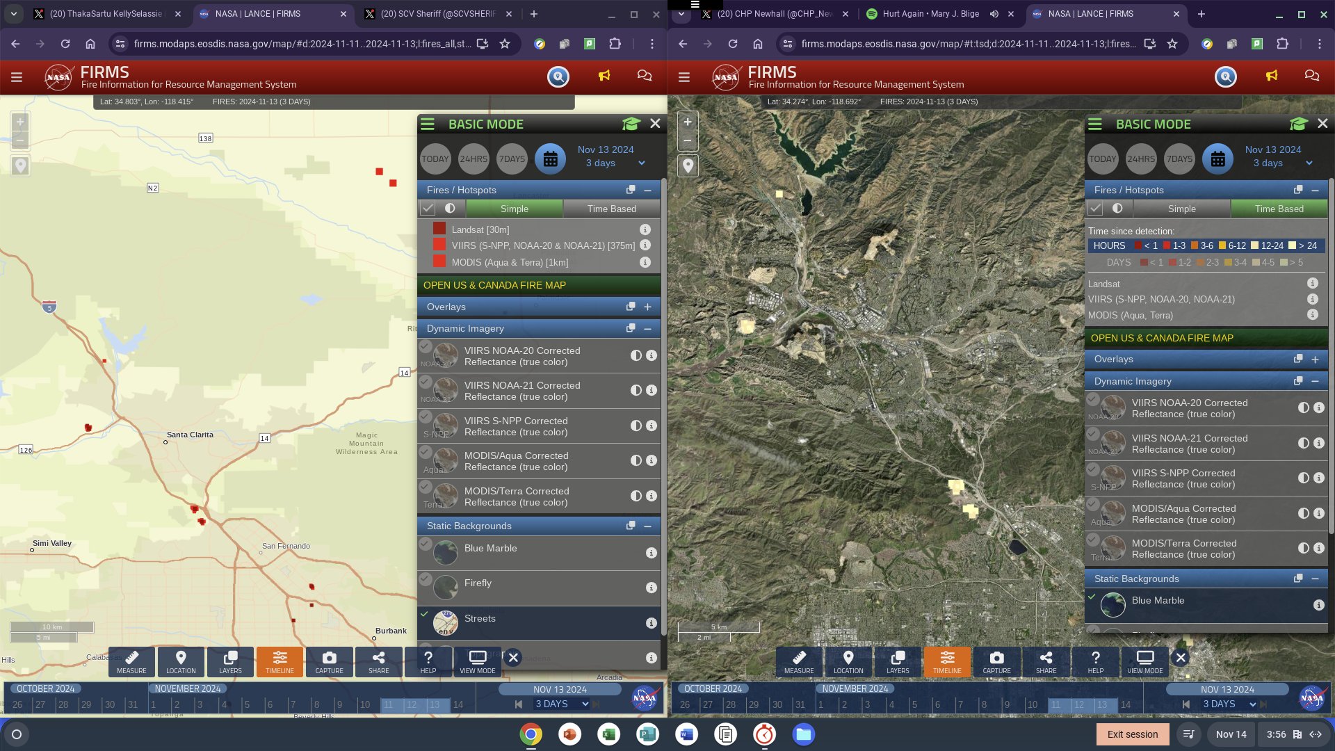
https://t.co/DpV21kcZnQ @elonmusk whatchu doin wit dat ? #frontlawncars @Tesla // @NASAJPL :: @NewhallCA @tla_antval @RepCardenas @SCVSHERIFF its #RashardiMANKellyNASAJPLFiREco from @nasajpl @ISS_Research #EcoStress its a #FireActivityReport @LAFDChief https://t.co/BToUMO954t pic.twitter.com/ozGZTWA5lm
— ThakaSartu KellySelassie (@thakasartu) November 14, 2024
![]()

![]() About the Fire Information for Resource Management System
NASA FIRMS uses satellite observations from the MODIS and VIIRS instruments to detect active fires and thermal anomalies and deliver this information in near real-time to decision makers through email alerts, analysis ready data, online maps and web services
About the Fire Information for Resource Management System
NASA FIRMS uses satellite observations from the MODIS and VIIRS instruments to detect active fires and thermal anomalies and deliver this information in near real-time to decision makers through email alerts, analysis ready data, online maps and web services
In other words "MODIS and VIIRS instruments" is only2
Things so that means the contraption does a lot more!
LANCE
Land, Atmosphere Near real-time Capability for Earth observation NASA’s Land, Atmosphere Near real-time Capability for Earth observation (LANCE) supports users interested in monitoring a wide variety of natural and human-created phenomena using near real-time (NRT) data and imagery that are made available much quicker than routine processing allows. ReadMore
Civic: Politics
Local Politician
https://t.co/R2hzIoq22Y @RepKarenBass what can we do to #SyncComms @usdisa #Municipal #Federal #Presidential @whitehouse #KamalaBrokeIt if she don't help #fixiT @normani @BlackGirlsCode @LACityView35 https://t.co/rUVnY7bMpM pic.twitter.com/OuxeHclA8K
— ricothaka (@ricothaka) November 8, 2024
Civic : @nasajpl i watched the documentary
watch on Youtube or NasaLive
NASA’s Jet Propulsion Laboratory is widely known for its trailblazing role in space exploration. As one JPL veteran put it, “You only get to explore the solar system for the first time once, and we did a lot of it.” And now, many of these adventures can be relived again in this series of documentaries: JPL and the Space Age that uses rare archival footage and interviews with many of JPL’s pioneering engineers and scientists in the retelling of many of humanity’s first steps out into the cosmos. @whitehouse @usdepartmentoflabor @blackgirlscode : : normani the library make it hard to keep up with these things @nasa

https://t.co/rgRqAdueaD https://t.co/8G1vHRD3OH https://t.co/LoWB7JOEDv @normani @ChloeBailey #STEMEDUCATiON @DisneyRecruiter I think ur name is #Penny 1 of u,im talking to the group @latto I want them to know Im an adult @nasajpl so #GitHub,#Hosting etc should be discussed @nasa pic.twitter.com/dfEV99JziH
— ricothaka (@ricothaka) November 6, 2024
Civic: Coyotes Downtown Los Angeles @deptofdefense
https://t.co/xjzi1CmhZn #GoodMorning! I walk past your building sometimes, #MyNameIsRashardiMAnKellyNASAJPLFirEco::dont get your feelings hurt! I slept n front of @LAPDHQ an a #Coyote walked by #DTLA 100 W 1st St #LosAngelesCA 90012 https://t.co/11mzCwxlQ7 https://t.co/eVo6BD5LOp pic.twitter.com/MQLKoElqu5
— ricothaka (@ricothaka) November 12, 2024

Los Angeles River: Alge Report @GEOS-ESM @nasa @nasa-jpl @NASA-Planetary-Science


https://t.co/PmVLeOcS4R #Dear_Mayor_Karen:#Yesterday #iSpentVeteransDay n @CountyofLA for @NASAJPL #ECOSTRESS @ISS_Research I ventured to #The_LA_RiVER after @SFCLA #breakfast+#coffee,thewater from the edge was 1cartsquare deep @zoeapie @a_feldman24 @USGS @NASAEarthData @normani pic.twitter.com/XRzWSPGd7b
— ricothaka (@ricothaka) November 12, 2024
https://t.co/fECbtXYOdb https://t.co/jThNVEBMwj #Dear_Governor_NewsoM @JenSiebelNewsom I want u to know we have an #AlgeGrowthIssue n @CountyofLA @LACityCouncil @SenBillNelson I was @metrolosangeles #A_LinE one side of the river had the #alge that could be #RedTide @a_feldman24 pic.twitter.com/kVQVAXEcAr
— ricothaka (@ricothaka) November 12, 2024
Android Forensics @blackgirlscode : : : normani

https://t.co/wAe9WEO7fL https://t.co/zxZbGIPuQD @LAFDChief u got a problem with me reading #SharedBooks, @LAPDHQ u think I gotta pay for books and games if I got relationships with the publisher!? #askNasa @BlackGirlsCode @normani @USDISA @USMarineCorps https://t.co/V4sDaJ9XCy pic.twitter.com/FwqFF1o5Lt
— ricothaka (@ricothaka) November 10, 2024
Personal Life
I tried to reach out to a @flickr friend i was secure visiting bc he was a Jehovahs Witness
#Mayor_Adams Hi did u ever work with https://t.co/BWeBE6YfE9 #RiCHBRAT u mad at me still? that was weird, Erika wit playboy, y u let us stay with u, y did we live together for 4 days, I'm sorry I could not photopal with u, Erika selfish! https://t.co/4PK4YJyEFO @AllentownPolice pic.twitter.com/VpnQ9DOxF2
— ricothaka (@ricothaka) November 9, 2024
https://t.co/vH9J7HwBvE @secdef... #GRAMMYsNominations are not kind to #AbandonedHusbands and support #Parentalalienation for a child molestation agenda @RecordingAcad fuck you - #rashard pic.twitter.com/u7ACsKIzEe
— ricothaka (@ricothaka) November 9, 2024
Computing : Css WebDev
I learned non destructive image editing there is a whole library on @mozilla’s mdn
.ic {
  filter: contrast(200%); }
with

Without
@SFCLA @SenBillNelson lives n #PASADENA I think, @TheRealBuzz cant b far he has a spot on #theWalkOfFame:#hollywood @VeronicaMcG they got sad #homeless eating there #BackgroundChecks can get u out of dumps!#Help! https://t.co/bQ4IeRNeha @NASAMars this is #CssImageEditing @Normani pic.twitter.com/ivILgG2PXt
— ricothaka (@ricothaka) November 8, 2024
![]()
layout: post title: Worklog date: 2024-11-13 22:51:06 -0800 published: true
<~ BACK!
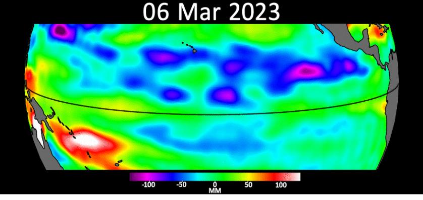
PIA25776: Early El Niño Signs 2023
Sea level data from the U.S.-European satellite Sentinel-6 Michael Freilich shows early signs of a developing El Niño along the equatorial Pacific Ocean. The measurements show Kelvin waves, low waves that can be tens of miles (hundreds of kilometers) wide, moving from west to east at the equator towards the west coast of Ecuador. When they form at the equator, Kelvin waves can move warm water – associated with higher sea levels – from the western Pacific to the eastern Pacific. Nasa Photo Journal:WeatheR
sea-level satellite
5 Things to Know About Sentinel-6 Michael Freilich
layout: default title: HoleToAnotherUniVersE