New Glenn had targeted a 2:50 p.m. EST (1850 GMT) liftoff from Blue Origin’s Space Launch Complex-36, at Cape Canaveral Space Force Station today (Nov. 12), to send NASA’s twin ESCAPADE orbiters to Mars. “However, due to highly elevated solar activity and its potential effects on the ESCAPADE spacecraft, NASA is postponing launch until space weather conditions improve,” Blue Origin wrote in a post on X.)
space.com - @TheSpaceDevs
Pioneering Low-Cost Planetary Exploration for NASA: the Escape and Plasma Acceleration and Dynamics Explorers TRaiLER
RocketLAb
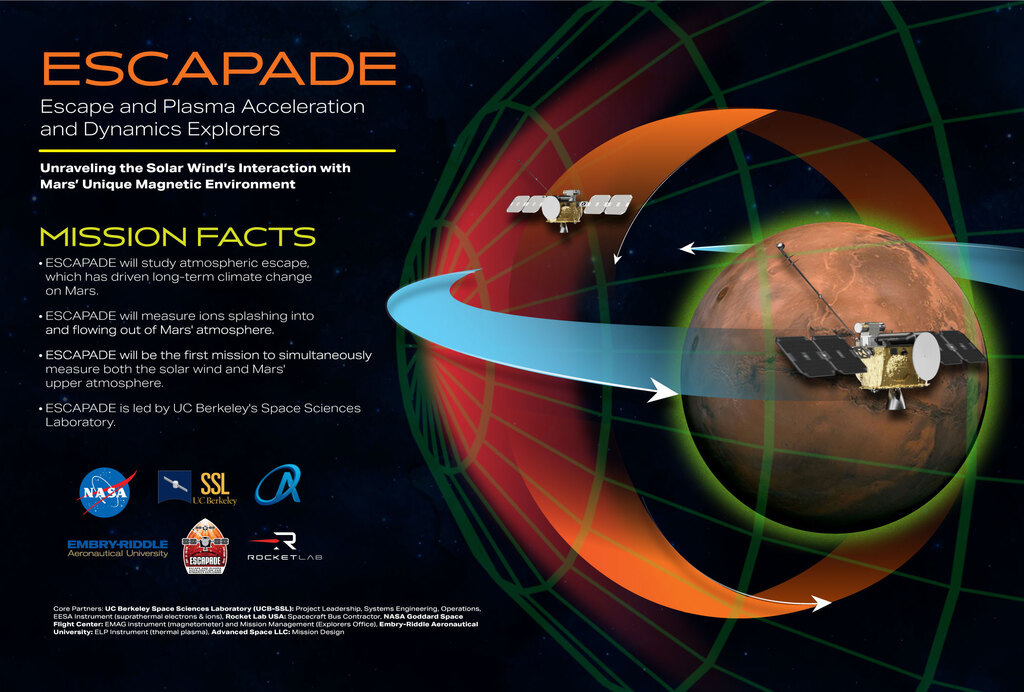
The Escape and Plasma Acceleration and Dynamics Explorers (ESCAPADE) mission to Mars, led by the University of California, Berkeley’s Space Sciences Laboratory, is set to launch sometime in fall 2024. It consists of two identical smallsats, named Blue and Gold, that will study Mars’ magnetosphere and its interaction with the solar wind. While the exact launch date is still to be determined, if the launch is successful, then ESCAPADE is projected to reach Mars by September 2025. READMORE
North Dakota Dual Aurora Camera (NoDDAC) Live Stream 11/11
Scrub: New Glenn Mission NG-2 Webcast
New Glenn’s second mission, NG-2, is scheduled to launch no earlier than Sunday, November 9, from Launch Complex 36 at Cape Canaveral Space Force Station. This mission will deliver NASA’s ESCAPADE twin spacecraft to Mars. Additionally, it will carry a technology demonstration from Viasat in support of NASA’s Communications Services Project.
– Launch Support @nasa @blueorigin @noaagov @blackgirlscode @normani
– I like Naylor to know im still a safe person @cityoflosangeles @whitehouse @stateofcalifornia
(MEPAG) November 2025 Meeting
Virtual - November 12, 2025@nasa-pds @nasa-jpl
Name
Mr. Rashard Iman “Rashard” Kelly
Company NASA: Jet Propulsion Laboratory LaCounty
Country United States
Telephone (818) 354-4321
Email holetoanotheruniverse40@gmail.com
ADA Special Needs ucla put some thing in my ankle that feels like a magnet… i gotta study more idk the probability of doom…
Civil Servant non-NASA U.S. Govt. employee
Registration Type Professional Virtual Registration
Amount b$0.00 Your badge will appear as:
Rashard
Kelly

NASA: Jet Propulsion Laboratory LaCounty [@nasa-jpl](https://archive.org/download/commitmentmaintenance/48584%20NASA%20Viking.mp4)
# Rashard Kelly NasaJpl MRO JUNO iSS [ALt - github.com/kellyrashardiman/kellyrashardiman.github.io](https://github.com/kellyrashardiman/kellyrashardiman.github.io/tree/master) + [homepage alt - kellyrashardiman.github.io](https://kellyrashardiman.github.io/) @nbcnews @nasa-jpl @nasa-pds @blackgirlscode . . . i think [ChloeBailey](https://www.siriusxm.com/blog/chloe-bailey-halle-bailey-call-her-daddy) and [Lana Harris](https://www.businesswire.com/news/home/20251223985439/en/ADDING-MULTIMEDIA-MediaCos-HOT-97-TV-Launches-Daily-Live-News-Show-for-the-First-Time-Dropping-January-2026) are the same person or they have been playing me for 7 years and [Chloe x Halle](https://www.grammy.com/artists/chloe-x-halle/243636/) and may be fraternal twins...
# Image of SATURN **File name:** [_N00211754_](https://solarsystem.nasa.gov/images/casJPGBrowseS79/N00211718.jpg).jpg **Taken**: Jun 14, 2013 5:02 PM **Received**: [Jun. 15, 2013 10:23 AM - _More Info_](https://solarsystem.nasa.gov/raw_images/319204/?layout=hds) **AnimationSourceFiles** [github.com/ThakaRashard/rashardmro/commit/bee07f46a74e38026891b6d48dc2a67a93edb09a](https://github.com/ThakaRashard/rashardmro/commit/bee07f46a74e38026891b6d48dc2a67a93edb09a) The camera was pointing toward SATURN, and the image was taken using the RED and CL2 filters. This image has not been validated or calibrated. A...
[raw.githubusercontent.com/ra5hard/ra5hard.github.io/refs/heads/master/_posts/2026-07-07-FloodPredictionAndModeling.md](https://raw.githubusercontent.com/ra5hard/ra5hard.github.io/refs/heads/master/_posts/2026-07-07-FloodPredictionAndModeling.md) ## Excercise1 Question 14 @nasa-jpl @nasa-openscapes Question: Which product shows maximum flooded area in South Sudan, and which product has maximum insufficient data to detect floods? - [3-day: 10.5067/MODIS/MCDWD_L3_F3_NRT.061 @podaac Flood 3 Day Window](https://www.earthdata.nasa.gov/data/instruments/viirs/near-real-time-data/nrt-global-flood-products) // [@nbcnews youtube.com/watch?v=Z3jdNseZGjE](https://www.youtube.com/watch?v=Z3jdNseZGjE) [worldview.earthdata.nasa.gov/?v=29.50696633282299,6.159819418469158,31.660053968216708,7.785831200718493&as=2026-05-15-T00%3A00%3A00Z&ae=2026-05-30-T00%3A00%3A00Z&l=Reference_Labels_15m,Reference_Features_15m,Coastlines_15m,MODIS_Combined_Flood_3-Day(disabled=4),MODIS_Combined_Flood_2-Day(hidden),VIIRS_Combined_Flood_3-Day(hidden),VIIRS_Combined_Flood_2-Day(hidden,disabled=4),OCI_PACE_True_Color,VIIRS_NOAA21_CorrectedReflectance_TrueColor,VIIRS_NOAA20_CorrectedReflectance_TrueColor,VIIRS_SNPP_CorrectedReflectance_TrueColor,MODIS_Aqua_CorrectedReflectance_TrueColor,MODIS_Terra_CorrectedReflectance_TrueColor&lg=true&al=true&ab=on&s=30.3438,7.2635&t=2026-05-15-T17%3A50%3A18Z](https://worldview.earthdata.nasa.gov/?v=29.50696633282299,6.159819418469158,31.660053968216708,7.785831200718493&as=2026-05-15-T00%3A00%3A00Z&ae=2026-05-30-T00%3A00%3A00Z&l=Reference_Labels_15m,Reference_Features_15m,Coastlines_15m,MODIS_Combined_Flood_3-Day(disabled=4),MODIS_Combined_Flood_2-Day(hidden),VIIRS_Combined_Flood_3-Day(hidden),VIIRS_Combined_Flood_2-Day(hidden,disabled=4),OCI_PACE_True_Color,VIIRS_NOAA21_CorrectedReflectance_TrueColor,VIIRS_NOAA20_CorrectedReflectance_TrueColor,VIIRS_SNPP_CorrectedReflectance_TrueColor,MODIS_Aqua_CorrectedReflectance_TrueColor,MODIS_Terra_CorrectedReflectance_TrueColor&lg=true&al=true&ab=on&s=30.3438,7.2635&t=2026-05-15-T17%3A50%3A18Z) [earthdata.nasa.gov/s3fs-public/2026-06/ARSET-Floods2026-part1-exercise.pdf](https://www.earthdata.nasa.gov/s3fs-public/2026-06/ARSET-Floods2026-part1-exercise.pdf) [](https://archive.org/download/SPACEBEACH/VirtiservMonitoringandPredictingFloodsUsingEarthObservationsExcercise1Recording2026-07-07_115158SPACEBEACH_RexRichardSONKarenBAss.mp4) # Excercise 2 16. **Consider the following questions:** >a)...
# MApping Fire and Chlorophyll [](https://ia601505.us.archive.org/28/items/longbeach_202605/SPACEBEACH_fireVirtiservRASHARD_NASAJPL_4_LATRiCE_FiTZPATRiCKRecording%202026-07-16%20135048%20-%20Copy.mp4) [worldview.earthdata.nasa.gov/?v=-123.77323523527713,41.39026488676639,-121.9101314679763,44.46956139105525&as=2026-07-10-T00%3A00%3A00Z&ae=2026-07-15-T00%3A00%3A00Z&l=Reference_Labels_15m(hidden),Reference_Features_15m(hidden),Coastlines_15m,MERIS_ENVISAT_Chlorophyll_a,MODIS_Aqua_L2_Chlorophyll_A(hidden),OCI_PACE_Chlorophyll_a(hidden),S3B_OLCI_Chlorophyll_a(hidden),S3A_OLCI_Chlorophyll_a(hidden),VIIRS_NOAA20_CorrectedReflectance_BandsM3-I3-M11,OCI_PACE_True_Color(hidden),VIIRS_NOAA21_CorrectedReflectance_TrueColor(hidden),VIIRS_NOAA20_CorrectedReflectance_TrueColor(hidden),VIIRS_SNPP_CorrectedReflectance_TrueColor(hidden),MODIS_Aqua_CorrectedReflectance_TrueColor(hidden),MODIS_Terra_CorrectedReflectance_TrueColor&lg=true&ab=on&t=2026-07-15-T00%3A00%3A00Z](https://worldview.earthdata.nasa.gov/?v=-123.77323523527713,41.39026488676639,-121.9101314679763,44.46956139105525&as=2026-07-10-T00%3A00%3A00Z&ae=2026-07-15-T00%3A00%3A00Z&l=Reference_Labels_15m(hidden),Reference_Features_15m(hidden),Coastlines_15m,MERIS_ENVISAT_Chlorophyll_a,MODIS_Aqua_L2_Chlorophyll_A(hidden),OCI_PACE_Chlorophyll_a(hidden),S3B_OLCI_Chlorophyll_a(hidden),S3A_OLCI_Chlorophyll_a(hidden),VIIRS_NOAA20_CorrectedReflectance_BandsM3-I3-M11,OCI_PACE_True_Color(hidden),VIIRS_NOAA21_CorrectedReflectance_TrueColor(hidden),VIIRS_NOAA20_CorrectedReflectance_TrueColor(hidden),VIIRS_SNPP_CorrectedReflectance_TrueColor(hidden),MODIS_Aqua_CorrectedReflectance_TrueColor(hidden),MODIS_Terra_CorrectedReflectance_TrueColor&lg=true&ab=on&t=2026-07-15-T00%3A00%3A00Z) [@cbs-news-data @longbeachinnovationteam @blackgirlscode @podaac @nbcnews](https://ladsweb.modaps.eosdis.nasa.gov/stream/map#map=15.93/-13155591.74/3996383.27&layers=aqv_secchi_20260616_sentinel:1.00:0.00:30.00:default) [ladsweb.modaps.eosdis.nasa.gov/stream/map#map=14.87/-13156018.70/3997144.64&layers=aqv_secchi_20260616_sentinel:1.00:0.00:30.00:default](https://ladsweb.modaps.eosdis.nasa.gov/stream/map#map=14.87/-13156018.70/3997144.64&layers=aqv_secchi_20260616_sentinel:1.00:0.00:30.00:default) ``` Name: Rashard I Kelly Username: rashardkelly Email Address: holetoanotheruniverse40@gmail.com Organization: Mars Reconnocinse Orbiter #NasaJPL #La_CanaDa_FlintRidge Los Angeles County California Country: United States Member Since: 08-24-2024 Last Authentication: 07-16-2026 Federated User: False Application Creator: False User Type:...
[@cityoflosnangeles @nasa-jpl @dhs-gov @commercegov](https://lamag.com/lahistory/l-s-26th-mayor-excellent-mustache-also-wildly-corrupt/) # Earthdata Overview  NASA · Small Steps, Giant Leaps: Episode 173: Soft Skills for Tough Missions ## Monitoring and Predicting Floods Using Earth Observations for Planning and Preparedness This three-part ARSET training covers flood monitoring via remote sensing, NASA flood...
 Artemis 2 LIVE: Astronauts begin stowing their gear for return Wednesday, April 9, 2026 [read](https://www.space.com/news/live/artemis-2-nasa-moon-mission-updates-april-9-2026) The Deep Space Program Science Experiment (DSPSE) @nasa-jpl @nasa-pds @la-county-isd @CityOfLosAngeles @StateOfCalifornia @blackgirlscode ~+ @Whitehouse @dhs-gov @atfweb @boeing - [**DSPSE**_`.catFile`_](https://pds-geosciences.wustl.edu/lunar/clem1-gravity-topo-v1/cl_8xxx/catalog/mission.cat) [NasaJpl_Flickr](www.flickr.com/photos/nasa-jpl) :: [Feb25 snapshot @nasa-jpl](https://web.archive.org/web/20250208075001/https://www.flickr.com/photos/nasa-jpl/) @nasa @la-county-isd @podaac @nasa-jpl `404: Not Found ° [NasaJpl_Flickr]...
# Jelly Fish Over LA friends of @blackgirlscode `The Truth Behind Iran’s "Jellyfish" Drones & Jared Kushner’s Albania Deal` - [watch](https://youtu.be/kmU09zbyjWE?t=2) [Elon Musk](https://www.tesla.com/elon-musk) co-founded and leads [Tesla, SpaceX](https://www.nytimes.com/2026/06/17/business/spacex-tesla-merger-elon-musk.html), Neuralink and The Boring Company. @nasa-jpl @nasa-pds [](https://ia800106.us.archive.org/16/items/skywatching_202605/00STstarlink%2017-45%20part1_SPACEXJELLYFISH%201VID_20260624_203326_997.mp4) part 2 Tracking with my cell as well [](https://ia800106.us.archive.org/16/items/skywatching_202605/00STarlink17-45%20part%202VID_20260624_203707_097.mp4) [TrackingStarman -whereisroadster.com](https://www.whereisroadster.com/) @tesla crs34 @nasa-jpl...
# N.A.S.A. space station [Current position of the ISS](https://www.astroviewer.net/iss/en/) [ISS High Definition Live Streaming Video of the Earth (HDEV)](https://eol.jsc.nasa.gov/esrs/hdev/) @TheSpaceDevs @BlackGirlsCode @emit-sds @stateofcalifornia @cityoflosangeles Library of Congress Control Number: [2019642104](https://www.loc.gov/item/2019642104/) Caption for frame no. 25: Chairman F. [James Sensenbrenner Jr](https://www.congress.gov/member/f-sensenbrenner/S000244)., R-Wis., makes his opening statement before the start of the...
# Covid BrainDumP @NIHGOV @Howard-university-web-service @USPTO @CityOfLosAngeles @StateOfCAlifornia [SARS/COViD/CoronaVirus](https://www.facebook.com/photo.php?fbid=1754571571371159&set=a.190274967800835&type=3) [CoronaVirus ? Patent?](https://www.facebook.com/permalink.php?story_fbid=pfbid0kLVPytXnbGmhZ8j1MatkzJdkmC68u9hQTVmk7R2Z54AVdvCUqFLv2Rt6XRQdP7H3l&id=100084464911565) ### COVID pandemic started in Wuhan market animals after all, suggests latest study The finding comes from a reanalysis of genomic data. By [Smriti](https://pubmed.ncbi.nlm.nih.gov/?cmd=search&term=Smriti%20Mallapaty) [Mallapaty](https://scholar.google.co.uk/scholar?as_q=&btnG=Search+Scholar&as_sauthors=%22Smriti%2BMallapaty%22) [The hunt for the origin of the COVID-19 pandemic has new leads. Researchers...
## Rashard Kelly MRO JUNO iSS [_ECOSTRESS_](https://ecostress.jpl.nasa.gov/gallerylist) [ALt @ForAtlanta - github.com/kellyrashardiman/kellyrashardiman.github.io](https://github.com/kellyrashardiman/kellyrashardiman.github.io/tree/master) + [homepage alt - kellyrashardiman.github.io](https://kellyrashardiman.github.io/) . . . @ucla hi from [Remote @Nasa-JPL](https://holetoanotheruniverse40.github.io/compiling/) [NASA’s SpaceX CRS-34 Dragon Returns Packed with Space Station Science] [READ](https://www.nasa.gov/missions/station/iss-research/nasas-spacex-crs-34-dragon-returns-packed-with-space-station-science/) May 15, 2026 [spacex.com/launches/crs34](https://www.spacex.com/launches/crs34) CRS-34 Mission After 30 days docked to the International Space Station,...
 ## Atlanta[!](https://youtu.be/_nsDBUyLWcU) _Martin Luther King Jr. came of age in one of the fastest growing cities in the United States._ - [Changing Atlanta](https://science.nasa.gov/earth/earth-observatory/changing-atlanta-147806/) [A-Town Players - Wassup Wassup ( Bankhead Bounce ) Atlanta Classic 1995](https://youtu.be/J90bUNuJ20k) {% highlight ruby %} 1 # HOLE_TO_ANOTHER_UNiVERSE############################## 2 # TO#################################################### 3 # ANOTHER############################################### 4...
# Rashard Kelly NasaJpl MRO JUNO iSS @nasa-pds Hi i did a github account for [that acountant i met](facebook.com/thevirtiservway/) back in atlanta. And in working to clear my self of the issues from covid lockdown gossip i saw that its still helpdesk! @nasa-jpl @blackgirlscode i cannot be contained in any...
@nasa-jpl @blackgirlscode im burning now i made it like a 3rd through gucci new tape @Cityoflosangeles @nasa-pds healing [@StateOfCalifornia another firepage @la-county-isd HOLLY J Mitchell](https://thakarashard.github.io/rashardmro/lafire) [](https://upload.wikimedia.org/wikipedia/commons/transcoded/8/8c/The_Santa_Rosa_Island_and_Sandy_Fires_Burn_in_Southern_California_%28CIRA_2026-05-19_-_nolabels%29.webm/The_Santa_Rosa_Island_and_Sandy_Fires_Burn_in_Southern_California_%28CIRA_2026-05-19_-_nolabels%29.webm.1080p.vp9.webm) [https://ladsweb.modaps.eosdis.nasa.gov/stream/archive/2026/136/LC09_L1TP_042037_20260516_20260516_02_T1](https://ladsweb.modaps.eosdis.nasa.gov/stream/archive/2026/136/LC09_L1TP_042037_20260516_20260516_02_T1) # Fire Chars Santa Rosa Island [Fire Chars Santa Rosa Island](https://worldview.earthdata.nasa.gov/?v=-120.2978175712207,33.73092549983125,-119.64509138763925,34.052189168312744&as=2026-05-11-T00%3A00%3A00Z&ae=2026-05-21-T00%3A00%3A00Z&l=Reference_Labels_15m(hidden),Reference_Features_15m(hidden),Coastlines_15m(hidden),VIIRS_NOAA21_Thermal_Anomalies_375m_Night,VIIRS_NOAA21_Thermal_Anomalies_375m_Day,VIIRS_NOAA21_Thermal_Anomalies_375m_All,MODIS_Terra_Thermal_Anomalies_Night,MODIS_Terra_Thermal_Anomalies_Day,MODIS_Terra_Thermal_Anomalies_All,VIIRS_SNPP_Thermal_Anomalies_375m_Night,VIIRS_SNPP_Thermal_Anomalies_375m_Day,VIIRS_SNPP_Thermal_Anomalies_375m_All,VIIRS_NOAA20_Thermal_Anomalies_375m_Night,VIIRS_NOAA20_Thermal_Anomalies_375m_Day,VIIRS_NOAA20_Thermal_Anomalies_375m_All,MODIS_Aqua_Thermal_Anomalies_Night,MODIS_Aqua_Thermal_Anomalies_Day,MODIS_Aqua_Thermal_Anomalies_All,MODIS_Combined_Thermal_Anomalies_Day,MODIS_Combined_Thermal_Anomalies_All,VIIRS_NOAA21_CorrectedReflectance_BandsM11-I2-I1,OCI_PACE_True_Color(hidden),VIIRS_NOAA20_CorrectedReflectance_TrueColor(hidden),VIIRS_SNPP_CorrectedReflectance_TrueColor(hidden),MODIS_Aqua_CorrectedReflectance_TrueColor(hidden),MODIS_Terra_CorrectedReflectance_TrueColor&lg=true&al=true&ab=on&t=2026-05-21-T00%3A00%3A00Z) [Download Zip](https://github.com/ThakaRashard/rashardmro/commit/8df925c7744d0456e8e09ac0e02852b678a518c4) [Maap Link @nasa-jpl](https://worldview.earthdata.nasa.gov/?v=-120.2978175712207,33.73092549983125,-119.64509138763925,34.052189168312744&as=2026-05-11-T00%3A00%3A00Z&ae=2026-05-21-T00%3A00%3A00Z&l=Reference_Labels_15m(hidden),Reference_Features_15m(hidden),Coastlines_15m(hidden),VIIRS_NOAA21_Thermal_Anomalies_375m_Night,VIIRS_NOAA21_Thermal_Anomalies_375m_Day,VIIRS_NOAA21_Thermal_Anomalies_375m_All,MODIS_Terra_Thermal_Anomalies_Night,MODIS_Terra_Thermal_Anomalies_Day,MODIS_Terra_Thermal_Anomalies_All,VIIRS_SNPP_Thermal_Anomalies_375m_Night,VIIRS_SNPP_Thermal_Anomalies_375m_Day,VIIRS_SNPP_Thermal_Anomalies_375m_All,VIIRS_NOAA20_Thermal_Anomalies_375m_Night,VIIRS_NOAA20_Thermal_Anomalies_375m_Day,VIIRS_NOAA20_Thermal_Anomalies_375m_All,MODIS_Aqua_Thermal_Anomalies_Night,MODIS_Aqua_Thermal_Anomalies_Day,MODIS_Aqua_Thermal_Anomalies_All,MODIS_Combined_Thermal_Anomalies_Day,MODIS_Combined_Thermal_Anomalies_All,VIIRS_NOAA21_CorrectedReflectance_BandsM11-I2-I1,OCI_PACE_True_Color(hidden),VIIRS_NOAA20_CorrectedReflectance_TrueColor(hidden),VIIRS_SNPP_CorrectedReflectance_TrueColor(hidden),MODIS_Aqua_CorrectedReflectance_TrueColor(hidden),MODIS_Terra_CorrectedReflectance_TrueColor&lg=true&al=true&ab=on&t=2026-05-21-T00%3A00%3A00Z) [https://science.nasa.gov/earth/earth-observatory/fire-chars-santa-rosa-island/](https://science.nasa.gov/earth/earth-observatory/fire-chars-santa-rosa-island/)  [@nasa-jpl @FEMA @la-county-isd @CityOfLOSANGELES @CityofSantaMonica](https://get.frantzlawgroup.com/los-angeles-wildfires/?utm_term=la%20county%20wildfire&utm_campaign=KB+-+Search+-+LA+County+Wildfire&utm_source=adwords&utm_medium=ppc&hsa_acc=3145810664&hsa_cam=22100286930&hsa_grp=170534171702&hsa_ad=728564297411&hsa_src=g&hsa_tgt=kwd-2391223258520&hsa_kw=la%20county%20wildfire&hsa_mt=b&hsa_net=adwords&hsa_ver=3&gad_source=1&gad_campaignid=22100286930&gbraid=0AAAAAo6zI4kVdtXMCd7STzX2IdhOtbmEg&gclid=Cj0KCQjwlerQBhDMARIsAB16H-VIfXWcWJjgOFVrdcImDUdGi9Xz73teIV5CVg4o-E_HXMbZ0HimLA4aAoNKEALw_wcB)...
 [Voyager 1 reached interstellar space in August 2012](https://www.jpl.nasa.gov/missions/voyager-1/) [`Voyager 1` finds wall of fire at 90,000 ºF — It’s impossible for us to cross ecoticias.com](https://www.ecoticias.com/en/voyager-1-finds-wall-of-fire-at-90000f/16450/) [The `Voyager 2` spacecraft, which has been in operation since 1977 and is the only spacecraft to have ever visited Uranus and Neptune, has...
 [bluproducts.com/devices/view-5](https://www.bluproducts.com/devices/view-5/index.html) **VIEW 5** packs a powerful punch with its MediaTek Helio A22 processor, 64GB of internal storage, and 3GB of RAM. Whether you're browsing the web, checking social media, or streaming your favorite shows, this phone delivers...
Curiosity  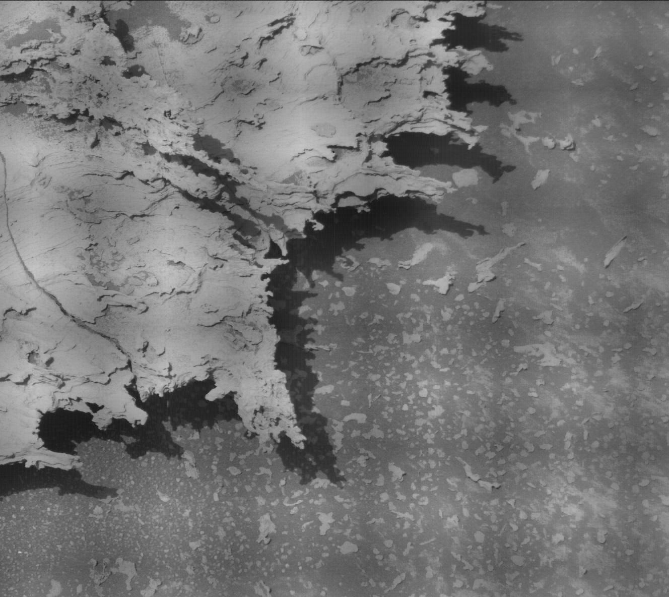 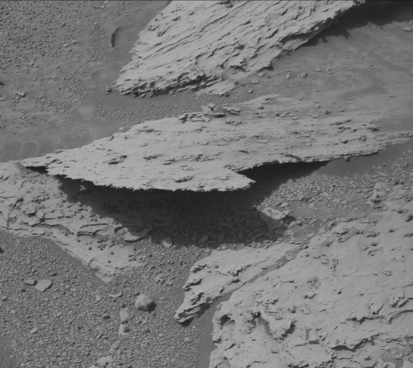 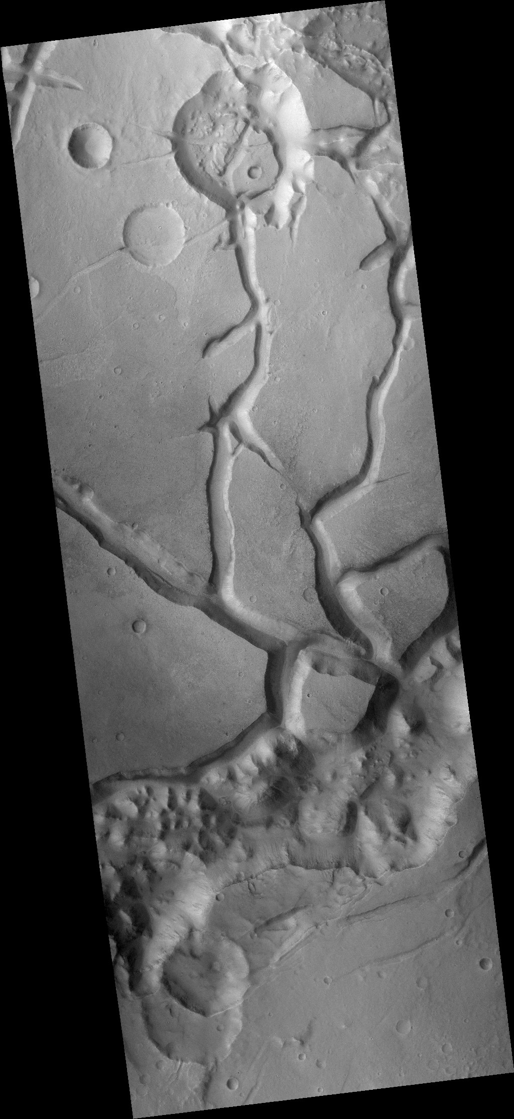 [uahirise.org/ctx/ESP/ORB_011700_011799/ESP_011701_1792/B05_011701_1792_XN_00S057W.browse.jpg](https://www.uahirise.org/ctx/ESP/ORB_011700_011799/ESP_011701_1792/B05_011701_1792_XN_00S057W.browse.jpg) 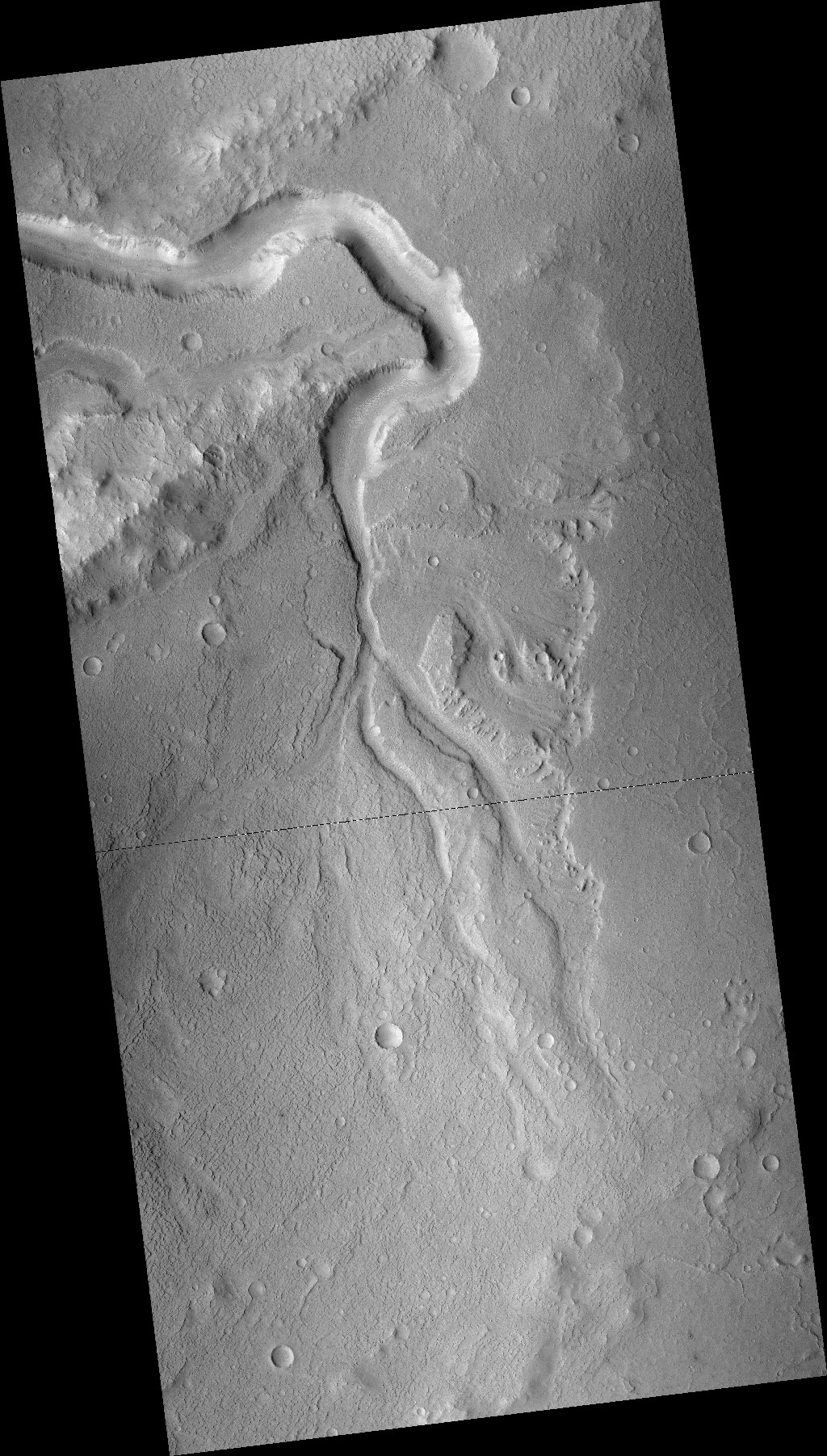 [@whitehouse kim bryant 4 @blackgirlscode b98.tv/video/pebbles-birthday-party/](https://www.b98.tv/video/pebbles-birthday-party/) 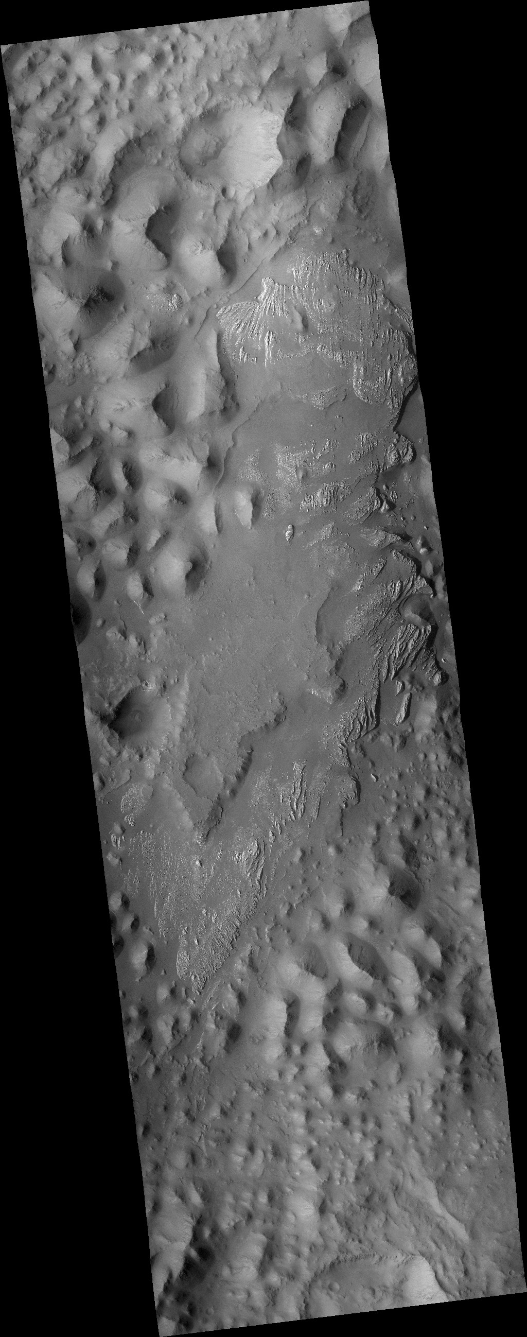 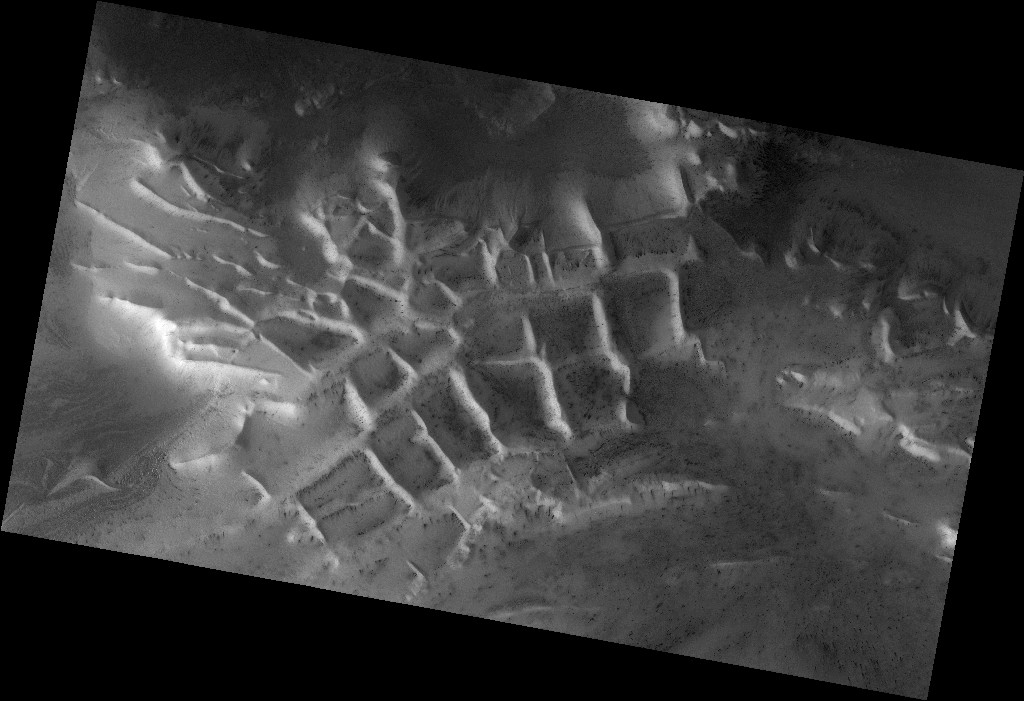 [@nasa-pds @blackgirslcode im itching @la-county-isd](https://archive.org/download/vid-20260411-163609-170/VirtisErvBlackgirlscodeRASHARDEARTHDATAMRO_JPL_JUNO_PSYCHE_SiGACCQUiSiTiONRecording%202026-05-15%20125534.mp4) @newshour MArs2020 Perseverance  @caltech i had the code for the Murray Labs mosaic, i cant find it. I hope i can find it...
# Jovian [PRESSKiT](https://www.jpl.nasa.gov/news/press_kits/juno/pdf/juno-lores.pdf) [[ joh-vee-uhn ]](https://en.wiktionary.org/wiki/Jovian) ([astronomy](https://www.nasa.gov/solar-system/skywatching/astronomy/)) Pertaining to the planet [Jupiter](https://ssd.jpl.nasa.gov/api/horizons.api?format=text&COMMAND=%27599%27&OBJ_DATA=%27YES%27&MAKE_EPHEM=%27YES%27&EPHEM_TYPE=%27OBSERVER%27&CENTER=%27500@399%27&START_TIME=%272006-01-01%27&STOP_TIME=%272006-01-20%27&STEP_SIZE=%271%20d%27&QUANTITIES=%271,9,20,23,24,29%27). [Jupiter is](https://www.jpl.nasa.gov/edu/resources/gallery/exploring-jupiter/)...the largest planet in our solar system – if it were a hollow shell, 1,000 Earths could fit inside [Jupiter Facts](https://science.nasa.gov/jupiter/jupiter-facts/) [Fiction/Fandom](https://aliens.fandom.com/wiki/Jovian) [Physicality @nasa PhotoJournal](https://photojournal.jpl.nasa.gov/target/jupiter) - [Program and Project Management](https://www.jpl.nasa.gov/news/press_kits/juno/management/) ~> [Directors](https://x.com/RicoThaka/status/1899890387977949299) [SPaniSH Deets](https://ciencia.nasa.gov/mission/europaclipper/) [Planetary Protection](https://sma.nasa.gov/sma-disciplines/planetary-protection) is...
## @NASA's [Artemis](https://www.nasa.gov/artemis-ii-press-kit/) II @nasa-jpl @foratlanta @stateofcalifornia [DOWNLOAD_PDF _`mep/Mars_Exploration_Program_Future_Plan.pdf`_](https://mars.nasa.gov/files/mep/Mars_Exploration_Program_Future_Plan.pdf) Landed Safely   @NASA’s Artemis II Crew Flies Around the Moon ([Watch the Official @nasa Broadcast](https://www.youtube.com/watch?v=z-j1uxBmis0)) [MotorWorld - Watch](https://www.youtube.com/watch?v=9j3wxCpcB_g) // [NasaSpaceFlight - Watch](https://www.youtube.com/watch?v=Fbpd2YB8seo) ~~@NASA's Artemis II Live Views from Kennedy Space CenteR~~ ~~Live Views~~ [LAUNCHED](https://youtu.be/nrVnsO_rdew) ::: [Radio](https://session.wefunkradio.com/radio/play) -...
# [Mars](https://youtu.be/SKlbDtWYHJk) Exploration Program NASA's Mars Exploration Program includes current missions Odyssey, MRO, Mars Express, MSL, InSight, and Mars 2020 [READMORE](https://pds-geosciences.wustl.edu/missions/mep/index.htm) [NaginCox](mailto:nagincox@outlook.com) @nasa-jpl I was try to email an update that curiosity was talking in [Goldstone](mailto:goldstonevc@jpl.nasa.gov) and my @protonmail @android client kept dropping connections sending me back to draft @blackgirlscode...
 First photograph (BW) taken of the famous Apollo 8 Earthrise sequence, the following images were acquired with color film [AS08-13-2329, NASA]. These color photographs give me a lot of comfort that the moon landing was real, they even went lomo on the website, some ppl would be mad at...
- Jump to [`news`](#news) - Jump to [`launch-weather`](#launch-weather) - Jump to [`flight-data`](#flight-data) ](https://svs.gsfc.nasa.gov/vis/a010000/a014900/a014995/ZGI_YouTube_Version.mp4)` @nbcnews @cbs-news-data + @la-county-isd @blackgirlscode @nasa-jpl NASA’s Applied Remote Sensing Training (ARSET) Program presents this certificate of completion to for completing the intermediate training: Monitoring Water Quality in Lakes and Coastal Regions Using STREAM @blackgirlscode [file for...
{% include nav.html %}  @podaac @nasa-jpl @blackgirlscode _Data center opposition is growing and impacting key midterm campaigns_ [@washingtonpost dot cOm/politics/2026/04/23/data-center-opposition-is-growing-impacting-key-midterm-campaigns/](https://www.washingtonpost.com/politics/2026/04/23/data-center-opposition-is-growing-impacting-key-midterm-campaigns/) [Pine Fire Georgia ? ](https://worldview.earthdata.nasa.gov/?v=-83.41565181885645,30.375860285712882,-81.5741970802516,31.28220128986996&l=Reference_Labels_15m(hidden),Reference_Features_15m(hidden),Coastlines_15m,MODIS_Terra_Thermal_Anomalies_Night(hidden),MODIS_Terra_Thermal_Anomalies_Day,VIIRS_NOAA20_Thermal_Anomalies_375m_Night(hidden),VIIRS_NOAA20_Thermal_Anomalies_375m_Day(hidden),MODIS_Aqua_Thermal_Anomalies_Night(hidden),MODIS_Aqua_Thermal_Anomalies_Day(hidden),VIIRS_SNPP_Thermal_Anomalies_375m_Night(hidden),VIIRS_SNPP_Thermal_Anomalies_375m_Day(hidden),VIIRS_NOAA20_CorrectedReflectance_BandsM3-I3-M11,VIIRS_NOAA20_CorrectedReflectance_TrueColor(hidden),VIIRS_SNPP_CorrectedReflectance_TrueColor(hidden),MODIS_Aqua_CorrectedReflectance_TrueColor(hidden),MODIS_Terra_CorrectedReflectance_TrueColor&lg=true&tr=fires_overview_2019&t=2026-04-23-T00%3A00%3A00Z) []( https://web.archive.org/web/20060108092026/http://mars.jpl.nasa.gov/mro/) ### [Mars Reconnaissance Orbiter](https://hirise-pds.lpl.arizona.edu/PDS/CATALOG/MISSION.CAT) : [Mission Objectives](https://www.google.com/logos/doodles/2025/fourth-of-july-2025-6753651837110704-2x.png) NASA's Mars Reconnaissance Orbiter searches for evidence that water persisted on the surface of Mars...
Watch Falcon 9 launch Dragon to the @Space_Station https://t.co/TaXjYl6jdX— SpaceX (@SpaceX) May 13, 2026 I dont know what to do with this yet @blackgirlscode [https://app.atlas.co/](https://app.atlas.co/) @stateofcalifornia @la-county-isd @nasa @doug-newman-nasa [_Active Outage🔴_](https://www.earthdata.nasa.gov/data/alerts-outages/ecostress-data-processing-issue) // [ Data Release🟩 ](https://www.earthdata.nasa.gov/data/alerts-outages/ecostress-version-3-level-2-data-products-released) [https://www.youtube.com/watch?v=vYRfQo6JMxc](https://www.youtube.com/watch?v=vYRfQo6JMxc) // https://youtu.be/Vi9OWHZeNCI?si=ReTK6kZYntFx-6mH [@Nasa Johnson - iss playlist https://youtube.com/playlist?list=PLTXQuaxXBKKwtqw9fmVw9YnMKxz6FcmWf&si=4RofY24OcifmTpdx](https://youtube.com/playlist?list=PLTXQuaxXBKKwtqw9fmVw9YnMKxz6FcmWf&si=4RofY24OcifmTpdx) [@nasa-jpl iss hatch opening and...
# Currently Compiling `jekyll.version` {{ jekyll.version }} #gaslighting #datingdisasters #toxicrelationships [WATCH -](https://youtu.be/ZC-pO2C-uNc) Could you forgive someone who lied about their identity, immigration status, and intentions for your relationship? That’s the nightmare Kay found herself in. This Dating Disaster is the first part of her shocking true story of betrayal, manipulation,...
 [comment]: (Emergency Files ) # Ecology-NorthAMERiCA[!](https://youtu.be/xjEoo14xHRs) [https://www.darienlibrary.org/](https://www.darienlibrary.org/) @esa @usgs [@UKSpaceAgency FOR _CamiLLA& CHarlsThe3rd @alphagov ~ @whitehouse @la-county-isd @JHUAPL @nasa-jpl @nasa-pdssdo.gsfc.nasa.gov/assets/img/dailymov/2026/04/28/20260428_1024_0171.mp4](https://sdo.gsfc.nasa.gov/assets/img/dailymov/2026/04/28/20260428_1024_0171.mp4) [Todays Files](https://sdo.gsfc.nasa.gov/assets/img/dailymov/2026/04/28/) [](https://sdo.gsfc.nasa.gov/assets/img/dailymov/2026/04/28/20260428_1024_0171.mp4) GRACE California Terrestrial Water Storage from 2018-06 to 2023-03. [https://gracefo.jpl.nasa.gov/](https://gracefo.jpl.nasa.gov/) [_**White House State Dinner for King Charles III & Queen Camilla**_](https://youtu.be/r2caMKmDEVY) [](https://svs.gsfc.nasa.gov/vis/a030000/a031200/a031231/grace_ca_water_2002-2023_seasonal_1080p.mp4) GRACE measures California water...
## NASA News Conference: Nancy Grace Roman Space Telescope is Complete [Watch youtube.com/watch?v=XX4f6dOoi08](youtube.com/watch?v=XX4f6dOoi08) Our new flagship telescope is fully assembled. Come find out what it will discover. We're hosting a news conference at NASA’s Goddard Space Flight Center in Greenbelt, Maryland, to talk about our Nancy Grace Roman Space Telescope,...
# About the United States Space Force ## Trump Signs Law Establishing U.S. Space Force [`READ` - trump-signs-law-establishing-us-space-force](https://www.war.gov/News/News-Stories/Article/Article/2046035/trump-signs-law-establishing-us-space-force/) Dec. 20, 2019 | By [Jim Garamone](https://www.war.gov/News/Author/58550/jim-garamone/) DOD News [@blackgirlscode @la-county-isd @cityoflosangeles @nasa @doug-newman-nasa @usnavy https://d34w7g4gy10iej.cloudfront.net/video/1912/DOD_107547647/DOD_107547647-1280x720-2765k.mp4](https://d34w7g4gy10iej.cloudfront.net/video/1912/DOD_107547647/DOD_107547647-1280x720-2765k.mp4) [](https://d34w7g4gy10iej.cloudfront.net/video/1912/DOD_107547647/DOD_107547647-1280x720-2765k.mp4) [](https://upload.wikimedia.org/wikipedia/commons/thumb/5/5a/Logo_of_the_United_States_Space_Force.png/250px-Logo_of_the_United_States_Space_Force.png) [The U.S. Space Force](https://www.spaceforce.mil/About-Us/) was established on Dec. 20, 2019, creating the first new...
# Heliophysics The Science Mission Directorate Heliophysics Division studies the nature of the Sun, and how it influences the very nature of space current visible [Sunspots](https://sdo.gsfc.nasa.gov/assets/img/dailymov/2026/04/02/) @nasa-pds @nasa-giss @nasa-jpl @la-county-isd @fbicyber ## CODEX _Coronal Diagnostic Experiment_ CODEX is a solar coronagraph installed on the International Space Station to gather important...
[@Nasa Johnson - iss playlist https://youtube.com/playlist?list=PLTXQuaxXBKKwtqw9fmVw9YnMKxz6FcmWf&si=4RofY24OcifmTpdx](https://youtube.com/playlist?list=PLTXQuaxXBKKwtqw9fmVw9YnMKxz6FcmWf&si=4RofY24OcifmTpdx) ## Atlanta[!](https://youtu.be/_nsDBUyLWcU) _Martin Luther King Jr. came of age in one of the fastest growing cities in the United States._ - [Changing Atlanta](https://science.nasa.gov/earth/earth-observatory/changing-atlanta-147806/) [A-Town Players - Wassup Wassup ( Bankhead Bounce ) Atlanta Classic 1995](https://youtu.be/J90bUNuJ20k) [@intuit @mailChimp theinfiniteatlanta.com/](https://theinfiniteatlanta.com/) [NASA’s SpaceX CRS-34 Dragon Returns Packed...
@blueorigin @nasa-jpl @blackgirlscode 4 new glenn3 https://www.nasa.gov/artemis-ii-weather-criteria/https://www.nasa.gov/wp-content/uploads/2025/12/sls-5558-artemis-ii-sls-reference-guide.pdfhttps://weather.ndc.nasa.gov/sport/viewer/?dataset=hovmoller&product=feds&location=al1325&mode=sc @nasa :Product: 3-Day Forecast :Issued: 2026 Apr 19 0030 UTC # Prepared by the U.S. Dept. of Commerce, NOAA, Space Weather Prediction Center # A. NOAA Geomagnetic Activity Observation and Forecast The greatest observed 3 hr Kp over the past 24 hours was...
## ThakaRashard ### rashardmro actually blog v3 alot of it all collapsed with the suspension of [RicoThaka](https://archive.org/details/screen-recording-2025-05-10-11.47.48-am) on @x f.k.a @twitter @nasa-jpl @foratlanta @la-county-isd if i have this data you have to see who using it in the schools @fbicyber [Commit c1a7e30](https://github.com/ThakaRashard/rashardmro/commit/c1a7e30d29fe97bdb601ba0ca32a87515b72e07e) i was recently asked to remove a tweet...
{% highlight python %} 1 # HOLE_TO_ANOTHER_UNiVERSE##########02/21/2026########## 2 # TO#####MsHOLLY,Hilda,Teresa,CB2,Janice&MayorKareN##### 3 # ANOTHER####Coral#######@nasa-jpl###################### 4 # UNiVERSE##LA_COUNTY_MAPS#####virtiservLA____########## {% endhighlight %}  [comment]: (Emergency Files ) @la-county-isd I recoreded notes about my experiances locally @datadesk and its where the mapping got started because i was [mapping mars](https://an.rsl.wustl.edu/) for [landings](https://www.jpl.nasa.gov/missions/mars-science-laboratory-curiosity-rover-msl/) CiViC-LosAngeles [Link](https://ra5hard.github.io/2025/08/21/civic.html) Written...
# Compiling @blackgirlscode @usgs i made a [News](https://thakarashard.github.io/news) page with some [Vlogging](https://archive.org/details/commitmentmaintenance) [https://www.youtube.com/lafd](https://www.youtube.com/lafd) @la-county-isd the graff riots @la-county-isd @cityoflosangeles @nasa-jpl {% for image in site.static_files %} {% if image.path contains 'assets/images/gallery-riotdata' | sort: 'date' | reverse %} {% endif %} {% endfor %} # [Just-Ice - Going Way Back @blackgirlscode...
### hotlinks [USGS WaTERDASHBOARD @usgs](https://dashboard.waterdata.usgs.gov/app/nwd/en/) [DSCOVR: EPIC _ Gallery : West Coast Wildfires](https://epic.gsfc.nasa.gov/galleries/2020/wildfires) [NASA - LANCE - FiRMS Global Fire Map, Live MAps](https://firms.modaps.eosdis.nasa.gov/map/) with [KML](https://developers.google.com/kml) - [downloads](https://firms.modaps.eosdis.nasa.gov/active_fire/) [@nasa it looks like cal fire uses ViiRS or another one of our climate sats @noaa for this map!](https://www.fire.ca.gov/incidents) `SupervisorLindsey` @la-county-isd @cityoflosangeles @nasa-pds...
# ~~ STOLEN ~~ @nasa-jpl @la-county-isd 2026-03-21-smartphone_lab.md [@blackgirlscode @esa @nasa-jpl](https://cdn.esawebb.org/archives/images/large/pillarsofcreation_composite.jpg) [@NASA-JPL / @CALTECH @Whitehouse @la-county-isd] @stateofcalifornia @CityOfLosAngeles @longbeachinnovationteam hi MAyorRex im pulling out some excerpts from an old include [`_UnixingAndroid_`](https://github.com/rashardsdata/rashardsdata.github.io/blob/master/_includes/unixingandroid.md), an include is a loose string that made the blog harder to port @CityOfLosAngeles @podaac @nasa-jpl # UnixinG_Android Hi MRO,...
# Rashard Kelly NasaJpl MRO JUNO iSS [ALt - github.com/kellyrashardiman/kellyrashardiman.github.io](https://github.com/kellyrashardiman/kellyrashardiman.github.io/tree/master) + [homepage alt - kellyrashardiman.github.io](https://kellyrashardiman.github.io/) # Rashard Kelly NasaJpl MRO JUNO iSS [ALt - github.com/kellyrashardiman/kellyrashardiman.github.io](https://github.com/kellyrashardiman/kellyrashardiman.github.io/tree/master) + [homepage alt - kellyrashardiman.github.io](https://kellyrashardiman.github.io/)   With a suite of cutting-edge instruments, Sentinel-3 measures systematically Earth’s oceans, land, rivers...
@la-county-isd MayorKAren here are some of my Analytics numbers, It helps clue in who been doing pranks on me sometimes @CityofLosAngeles @nasa-jpl @Nasa-openscapes @doug-newman-nasa i dont know who work the girls i was at the dance class with @disney but imma be real i just wanted another female in my...
[comment]: (Emergency Files ) {% highlight python %} 1 # HOLE_TO_ANOTHER_UNiVERSE############################ 2 # TO#####MsHOLLY,KieSHa,Teresa,theMayor&Latrice####### 3 # ANOTHER####Funeral?#######@nasa-jpl################# 4 # UNiVERSE#####################virtiserv____########## We acknowledge the use of imagery from the NASA Worldview application (https://worldview.earthdata.nasa.gov), part of the NASA Earth Science Data and Information System (ESDIS). {% endhighlight %} @whitehouse [Memorialservice](https://youtu.be/jdoGf55FUWE?t=2222&si=YVHuVU03aOzGL4S0) thanks for...
[comment]: (Emergency Files ) {% highlight python %} 1 # HOLE_TO_ANOTHER_UNiVERSE############################ 2 # TO#####MsHOLLY,KieSHa,Teresa,theMayor&Latrice####### 3 # ANOTHER####Funeral?#######@nasa-jpl################# 4 # UNiVERSE#####################virtiserv____########## We acknowledge the use of imagery from the NASA Worldview application (https://worldview.earthdata.nasa.gov), part of the NASA Earth Science Data and Information System (ESDIS). {% endhighlight %} maps between chicago and...
@TheSpaceDevs @BlueOrigin what would rodman of berkeley glass house lexus ass say about me today? please tell @blackgirlscode @nasa-jpl @la-county-isd somafm [SpaceStationSOMA](https://somafm.com/spacestation/) OR [Deep Space One](https://somafm.com/deepspaceone/) [current](https://youtu.be/d8yGrk0Sfxg?t=2335) = [UHF](https://dn720405.ca.archive.org/0/items/uhf_20221230/UHF.mp4) // [WeFUNK](https://session.wefunkradio.com/radio/play) [The International Space Station](https://www.nasa.gov/wp-content/uploads/2023/10/51891661735-cbeca97c4d-o.jpg?resize=1024,683) is pictured from the SpaceX Dragon crew spacecraft during a fly around of the orbiting...
@Tesla During the riots and beyond, EV vandalism {% for image in site.static_files %} {% if image.path contains 'assets/images/gallery-ev' | sort: 'date' | reverse %} {% endif %} {% endfor %} @la-county-isd fire report : Thermal Anomolies [https://worldview.earthdata.nasa.gov/?v=-166.20725846428957,-25.176674928960352,30.586845412762585,72.50289850584731&l=Reference_Labels_15m(hidden),Reference_Features_15m(hidden),Coastlines_15m(hidden),MODIS_Aqua_Thermal_Anomalies_All,VIIRS_NOAA21_Thermal_Anomalies_375m_Night,VIIRS_NOAA21_Thermal_Anomalies_375m_Day,VIIRS_NOAA21_Thermal_Anomalies_375m_All,VIIRS_NOAA20_Thermal_Anomalies_375m_All,VIIRS_NOAA20_Thermal_Anomalies_375m_Day,VIIRS_NOAA20_Thermal_Anomalies_375m_Night,VIIRS_SNPP_GapFilled_BRDF_Corrected_DayNightBand_Radiance(hidden),VIIRS_NOAA21_DayNightBand,OCI_PACE_Chlorophyll_a,OCI_PACE_Photosynthetically_Available_Radiation,OCI_PACE_True_Color(hidden),VIIRS_NOAA21_CorrectedReflectance_TrueColor(hidden),VIIRS_NOAA20_CorrectedReflectance_TrueColor(hidden),VIIRS_SNPP_CorrectedReflectance_TrueColor(hidden),MODIS_Aqua_CorrectedReflectance_TrueColor(hidden),MODIS_Terra_CorrectedReflectance_TrueColor&lg=true&t=2026-02-23-T01%3A57%3A46Z](https://worldview.earthdata.nasa.gov/?v=-166.20725846428957,-25.176674928960352,30.586845412762585,72.50289850584731&l=Reference_Labels_15m(hidden),Reference_Features_15m(hidden),Coastlines_15m(hidden),MODIS_Aqua_Thermal_Anomalies_All,VIIRS_NOAA21_Thermal_Anomalies_375m_Night,VIIRS_NOAA21_Thermal_Anomalies_375m_Day,VIIRS_NOAA21_Thermal_Anomalies_375m_All,VIIRS_NOAA20_Thermal_Anomalies_375m_All,VIIRS_NOAA20_Thermal_Anomalies_375m_Day,VIIRS_NOAA20_Thermal_Anomalies_375m_Night,VIIRS_SNPP_GapFilled_BRDF_Corrected_DayNightBand_Radiance(hidden),VIIRS_NOAA21_DayNightBand,OCI_PACE_Chlorophyll_a,OCI_PACE_Photosynthetically_Available_Radiation,OCI_PACE_True_Color(hidden),VIIRS_NOAA21_CorrectedReflectance_TrueColor(hidden),VIIRS_NOAA20_CorrectedReflectance_TrueColor(hidden),VIIRS_SNPP_CorrectedReflectance_TrueColor(hidden),MODIS_Aqua_CorrectedReflectance_TrueColor(hidden),MODIS_Terra_CorrectedReflectance_TrueColor&lg=true&t=2026-02-23-T01%3A57%3A46Z) We acknowledge the use of imagery from the NASA Worldview application (https://worldview.earthdata.nasa.gov),...
# Tommy The Clown [instagram](https://www.instagram.com/tommytheclown/?hl=en) [@nasa-pds - he know akire @blackgirlscode tommytheclownbattlezone.com](https://www.tommytheclownbattlezone.com/) [LAPhil TommyTheClown](https://www.laphil.com/musicdb/artists/7843/tommy-the-clown) @nasa-jpl call him and ask for his opinion of me [@TikTok](https://www.tiktok.com/@officialtommytheclown?lang=en) [@deptofwar thakarashard.github.io/rashardmro/longbeach](@deptofwar) [1982 R 1h 22m @la-county-isd @nasa-jpl @blackgirlscode](https://youtu.be/H3n5zaUoecI?si=3gujtbPLLPn9nsFx) - [_Charlie Ahearn_](https://www.imdb.com/title/tt0084904/) @la-county-isd If Latrice writes geek, check on her @blackgirlscode she may have lost...
# [Board of Supervisors](https://lacounty.gov/government/board-of-supervisors/) / [Kathryn Barger](https://lacounty.gov/government/board-of-supervisors/kathryn-barger/) @la-county-isd [SuperVisor_Barger?](mailto:kathryn@bos.lacounty.gov), I saw on the [HAhn building](https://www.yelp.com/biz/kenneth-hahn-hall-of-administration-los-angeles) two weeks ago that there is a [biweekly fire reporting meeting](https://assets-us-01.kc-usercontent.com/0234f496-d2b7-00b6-17a4-b43e949b70a2/52e87f40-eca4-476e-b063-d47827266d57/Agenda%20021026_links.pdf#page=27) . . . the new list super long and i was sleepy and did not take notes, but i am going to try to...
Survey of Terrain around Ice-Exposing Crater [link](https://www.uahirise.org/ESP_090417_2195) @la-county-isd @blackgirlscode i have to tell you im working on mars so those film people dont get rude with me at that level im upset . . [http://redplanet.asu.edu/](http://redplanet.asu.edu/)  [https://hirise-pds.lpl.arizona.edu/PDS/EXTRAS/ANAGLYPH/ESP/ORB_090600_090699/ESP_090628_2195_ESP_090417_2195/ESP_090628_2195_ESP_090417_2195_RED.browse.png](https://hirise-pds.lpl.arizona.edu/PDS/EXTRAS/ANAGLYPH/ESP/ORB_090600_090699/ESP_090628_2195_ESP_090417_2195/ESP_090628_2195_ESP_090417_2195_RED.browse.png) ## Curiosity The Mars Science Laboratory’s Curiosity has the unique ability to capture...
[Towards global long-term water transparency products from the Landsat archive](https://www.sciencedirect.com/science/article/pii/S0034425723004406?via%3Dihub) : @cityoflosangeles [Mayor](https://healthpolicy.ucla.edu/30-year-anniversary/honorees/mayor-karen-bass) @ucla thats a link :: news _Casey Wasserman Loses L.A Mayor’s Support For LA28 Job Over Epstein Files Revelations: “He Should Step Down”_ [Link](https://deadline.com/2026/02/casey-wasserman-resign-olympics-mayor-karen-bass-esptein-1236726528/) _`Mayoral Transition Advisory Team`_ ? [Link - https://jobs.lamayor.org/mayoral-transition-advisory-team](https://jobs.lamayor.org/mayoral-transition-advisory-team) @la-county-isd {% for image in...
categories: mars # Comparison View of Mars Cloud Cover [link](https://assets.science.nasa.gov/content/dam/science/psd/photojournal/pia/pia01/pia01246/PIA01246.jpg) :: [ReadArticle](https://science.nasa.gov/photojournal/comparison-view-of-mars-cloud-cover/) 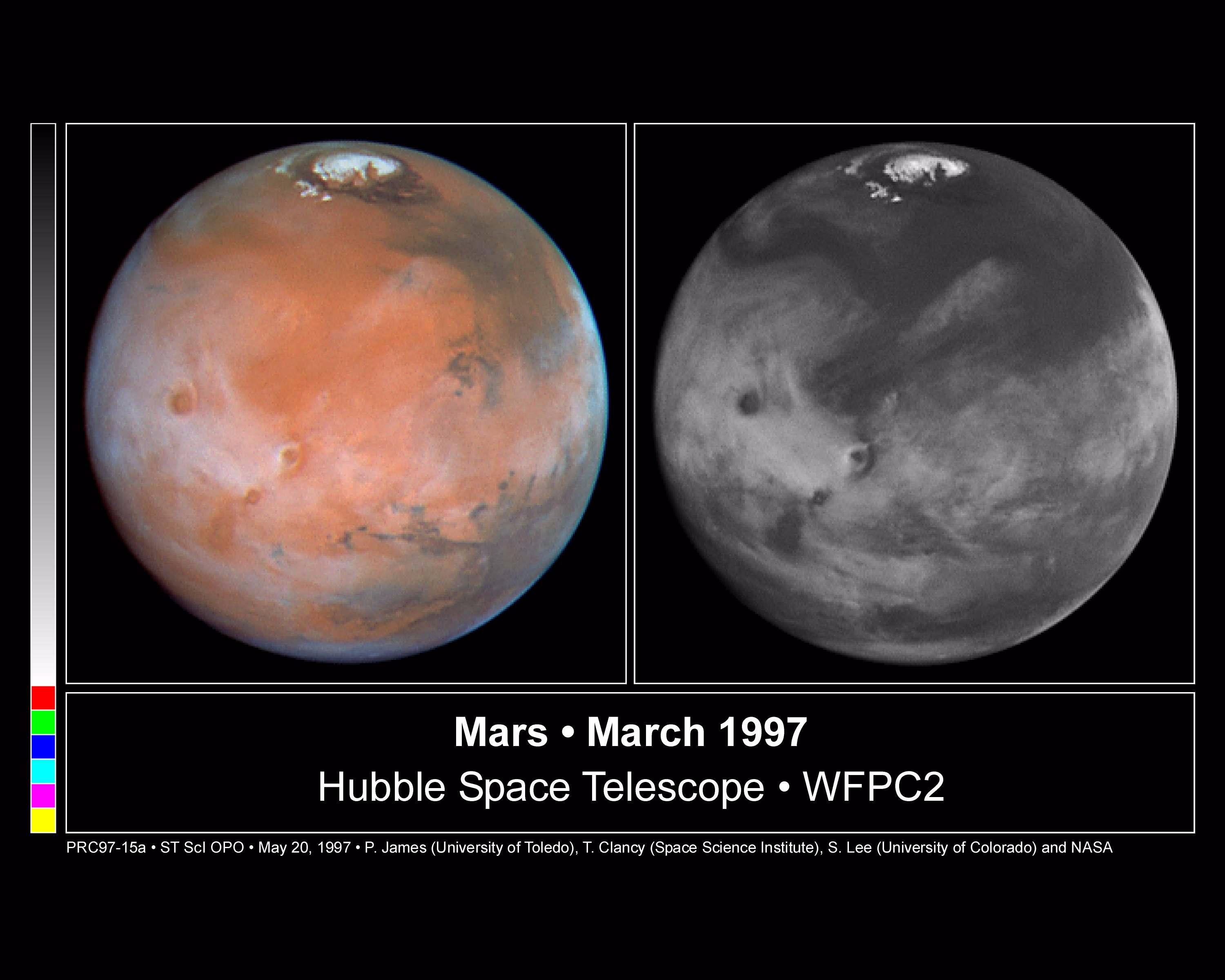 Description These color and black and white pictures of Mars were taken by NASA's Hubble Space Telescope just two weeks after Earth made its closest approach to the Red Planet during the 1997 opposition. When the Hubble...
@blackgirlscode [GymTeacherShit](https://youtu.be/9jRKsH8_OWQ?si=52rMxhLnKzTVtl9Q) normani there you go! @emit-sds @la-county-isd [mrs holly mitchell](https://www.cbsnews.com/losangeles/video/supervisor-holly-mitchell-responds-to-fire-at-chevron-refinery-in-el-segundo/) the only reason im reaching out is because im scared of [ltrice fitzpatrick](https://www.facebook.com/thevirtiservway/) @nasa-jpl @nasa-pds @nasa @whitehouse @cityoflosangeles ## SpaceWeather 4 [Splashdown](https://www.youtube.com/live/EqT3nDbwETc?si=3lNL5Pg-p3JSSE1G) # San Diego @SpaceExplorationTechnologies "Dragon [SpaceX](https://www.facebook.com/ISS/videos/a-mission-to-inspire-may-30-2025/1683840579191525/) is no longer [privatized](https://www.nasa.gov/humans-in-space/commercial-space/commercial-crew-program/commercial-crew-program-essentials/)" - @nsa @r-spacex announcer @blackgirlscode @cityoflosangeles @la-county-isd...
CARL SAGAN MARS THE SEARCH BEGINS NASA MARINER & VIKING MISSIONS 48614 [WATCH](https://www.youtube.com/watch?v=yhv5V_8RPiI) @nasa-pds @blackgirlscode @cityoflosangeles Famed astronomer and Cornell University scientist Carl Sagan takes the viewer to the Red Planet in this circa 1972 official NASA film, “Mars: The Search Begins.” Sagan explains that not much was known about...
Los Angelels SarView @blackgirlscode + fb @nasa-jpl @nasa-pds Caltrans Encampment Resource Network Tutorial + MAP @cagov culvercity.gov @stateofcalifornia Encampment Resolution stream eosdis.nasa.gov The Los Angeles City Hall, Calif. STEREOGRAPH LA 92 LA92 Alt LA92 Panel - Live National Geographic LA Stories: The 1992 Riots That Shook the City “ WATTS...
Currently Compiling jekyll.version 3.10.0 TeslaDiner Revolt hey, ho ho, elon musk has got to go~ Akira - Pioneer Dub What does it mean if a movie is dubbed in English? - quora.com The two Akira dubs - different intended audiences? - r/Animedubs Akira Subtitles opensubtitles.org + Adding captions and subtitles...
Mars Work I documented some articles about things that happened before and after my arrival Nagin Cox grew up hearing that girls were "worthless"-so she set her sights on NASA and never looked back. - ReadHerStory MAliBuTimEs Nagin Cox in All About Space MRO 10Year Anniversary Issue NAgin Cox: Livin...
@blueorigin @emit-sds @blackgirlscode archive.org/details/commitmentmaintenance/0000000_VID_20251109_141641_311.mp4 @nasa-jpl @cisa the launch moved to Wednesday according to @blueorigin @stateofcalifornia @cityoflosangeles Our next launch attempt is no earlier than Wednesday, November 12, due to forecasted weather and sea state conditions. We worked with the FAA and range to select a launch window from 2:50 PM...
Firstlayout b4 Leap Day it was a lot of modding of pages-themes hacker i did so well with ThakaRashard stability wise I knew that was the logical move for my LinkediN_Replacement for general iDentification Online … my HomePage Mars Mission Objectives MArs Reconnocinse Orbiter Laila’s Wisdom re:coral @blackgirlscode 1879 California...
Targeting Sunday, June 22 for a Falcon 9 launch of the Transporter-14 mission from Space Launch Complex 4E in California. Teams are keeping an eye on weather → https://t.co/bJFjLCiTbK pic.twitter.com/UUJMwtwOFS— SpaceX (@SpaceX) June 21, 2025 Dear Coral RicoThaka and MoonLover404back Groove Theory - Come Home Coral I dont know the...
Rashard (Thaka) Iman Kelly(Selassie?) NASAJPL MRO PAsadena California East Los Angeles Sheriff’s Station 45 CFR § 2554.4 - What is a statement? 2009 California Evidence Code - Section 100-260 :: Division 2. Words And Phrases Defined :: “Statement” means (a) oral or written verbal expression or (b) nonverbal conduct of...
@doug-newman-nasa someone sent me this, i think its latrice @blackgirlscode @howard-university-web-services archive.org/download/tumblr_rtxuqxFIjQ1zhx4f1/trunkmusic.mp4 @disney idk if shes chloe baily @ksc-newsroom@mail.nasa.gov @nasa @la-county-isd https://archive.org/download/tumblr_rtxuqxFIjQ1zhx4f1/trunkmusic.mp4 @douglas.j.newman@nasa.gov @jisaacman@shift4.com https://melodymaddox.com/ @nasa-jpl all municipalities need to share dns sources with the public @cisa @lacmta @whitehouse @nasa-develop @blackgirlscode @cityoflosangeles @foratlanta treason @newshour @la-county-isd hollyjmitchell coral know the black man...
AnimalFarm 1954
********************************************************************************

                         U.S. GOVERNMENT COMPUTER

This US Government computer is for authorized users only.  By accessing this
system you are consenting to complete monitoring with no expectation of privacy.
Unauthorized access or use may subject you to disciplinary action and criminal
prosecution.

Attention user: You are downloading data from NASA's Land Processes Distributed
Active Archive Center (LP DAAC) located at the USGS Earth Resources Observation and
Science (EROS) Center.

This data is open to the public and browse images are freely available without
restriction.  Satellite data products may require a NASA Earthdata Login username
and password.  To obtain a NASA Earthdata Login account, please visit
https://urs.earthdata.nasa.gov/users/new/.

For more information about the data you are downloading, including documentation
and how to properly cite the data, please visit https://lpdaac.usgs.gov/.

********************************************************************************
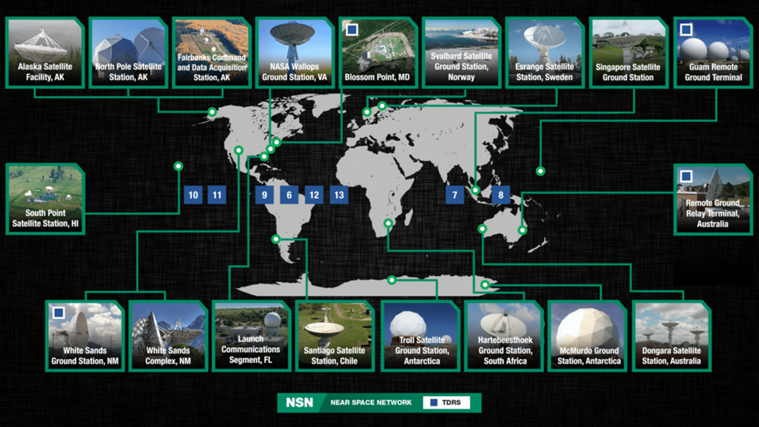
Iwas looking ScanDTE the NearSpaceNetwork and a signal from ICEsat-2 came through at the Alaska Satellite Field Mayor Karen Bass thats why I told the people defending justice at the art party that “iM ICe! They dont read too well!” @stateofCalifornia @cityoflosangeles @nasa-jpl it was not a good joke and i got hurt but @blackgirlscode I know the people that began thier wall writing journey in Atlanta and Would know about my badge, and I have suspicions whiteamericabrokeintoo!LYRiCs and the whole thing is this @whitehouse @nasa im just trailing . . . just know i know those dance-people are involved with the ArtRiots
The Bronco Space Lab will be holding an F Prime Tutorial on Friday April 11, 2025 from 9AM - 4PM. The tutorial will take place in the Bronco Space Lab at 3670 W Temple Ave STE 278, Pomona CA 91768.
F Prime is a free, open-source and flight-proven flight software development ecosystem developed at the NASA Jet Propulsion Laboratory that is tailored for small-scale systems such as CubeSats, SmallSats, and instruments. To learn more about F Prime, visit their documentation page!
The Bruce Murray Laboratory for Planetary Visualization has completed a 5.7 terapixel mosaic of the surface of Mars rendered at 5.0 m/px. Each pixel in the mosaic is about the size of a typical parking space, providing unprecedented resolution of the martian surface at the global scale.
********************************************************************************

                         U.S. GOVERNMENT COMPUTER

This US Government computer is for authorized users only.  By accessing this
system you are consenting to complete monitoring with no expectation of privacy.
Unauthorized access or use may subject you to disciplinary action and criminal
prosecution.

Attention user: You are downloading data from NASA's Land Processes Distributed
Active Archive Center (LP DAAC) located at the USGS Earth Resources Observation and
Science (EROS) Center.

This data is open to the public and browse images are freely available without
restriction.  Satellite data products may require a NASA Earthdata Login username
and password.  To obtain a NASA Earthdata Login account, please visit
https://urs.earthdata.nasa.gov/users/new/.

For more information about the data you are downloading, including documentation
and how to properly cite the data, please visit https://lpdaac.usgs.gov/.

********************************************************************************


